The need for ocean awareness through Space was highlighted in the 30th Anniversary of the UN Convention on the Law of the Sea, 2012. A taskforce was created in the European Space Agency to address these specific needs and opportunities, the Blue Worlds Task Force. The need is also identified by the Portuguese government in the National Strategy for the Sea (ENM2030), as it can leverage the national space industry and create indirect economic benefits. Identified through differente surveys, the needs are grouped in three segments: Maritime Surveillance, Aquaculture & Maritime Environment and AIS data. The current world context requests for EU countries and countries themselves to be independent in collecting valuable information, and food-chain and environmental concerns have demonstrated growing potential interest. ATON constellation follows a low-risk and cost-efficient approach to meet these user needs by leveraging on mature platforms and technology and effectively framing the requirements. This is achieved with Lusospace 20 years’ experience in the space sector and partnering with key players in the sector (AAC Clyde Space, GMV, AIR Centre) and national authorities (Portuguese Navy). The product is a near end-to-end solution, from Space segment to data delivery through a services center.
Customers and their Needs
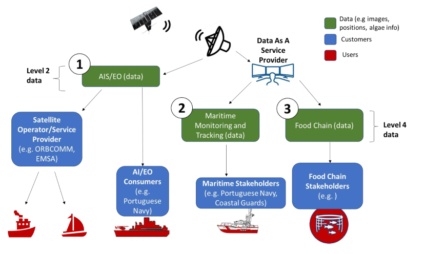
The customers are segmented in three: Maritime Surveillance, Aquaculture & Maritime Environment and AIS data.
For maritime surveillance, the activity involved Portuguese Navy and GMV, the former being a potential customer that aids in requirement definition, and the latter a key player in maritime surveillance solutions. The Portuguese territory has over 2 000 km of coastline and an exclusive Economic Zone (EEZ) of around 1.7 million km2; and is currently waiting for an update of this EEZ to 3.8 million km2. For security and sovereignty reasons, it’s becoming increasingly valuable to have EU providers of data and services, ensuring that the exchange in information is secure. Low revisit-times and possibility to customized areas of coverage add significant value according to potential customers, such as the Portuguese Navy. This applies to other national authorities within EU and others.
Aquaculture segment addresses the estimated loses of 2B€ due to Harmful Algae bloom events. This is a market to be uncovered but according to the surveys performed by partner AIR Centre, the need to purchase such services exist and customers are willing to pay. The hyperspectral payload allows also to monitor maritime environment for R&D institutions and complement other existing products that have higher revisit-times. The third segment addresses AIS data. There is a market push to obtain more data and entities such as EMSA and ORBCOMM confirmed the interest in buying such data. VDES technology will be a market disruption and the constellation has the means to use it and test it with early adopters.
Targeted customer/users countries
Portuguese Navy and other national authorities within EU and others.
Product description
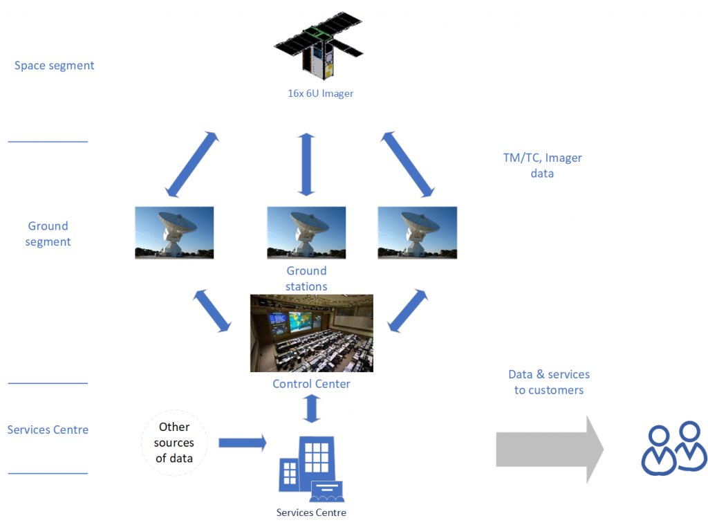
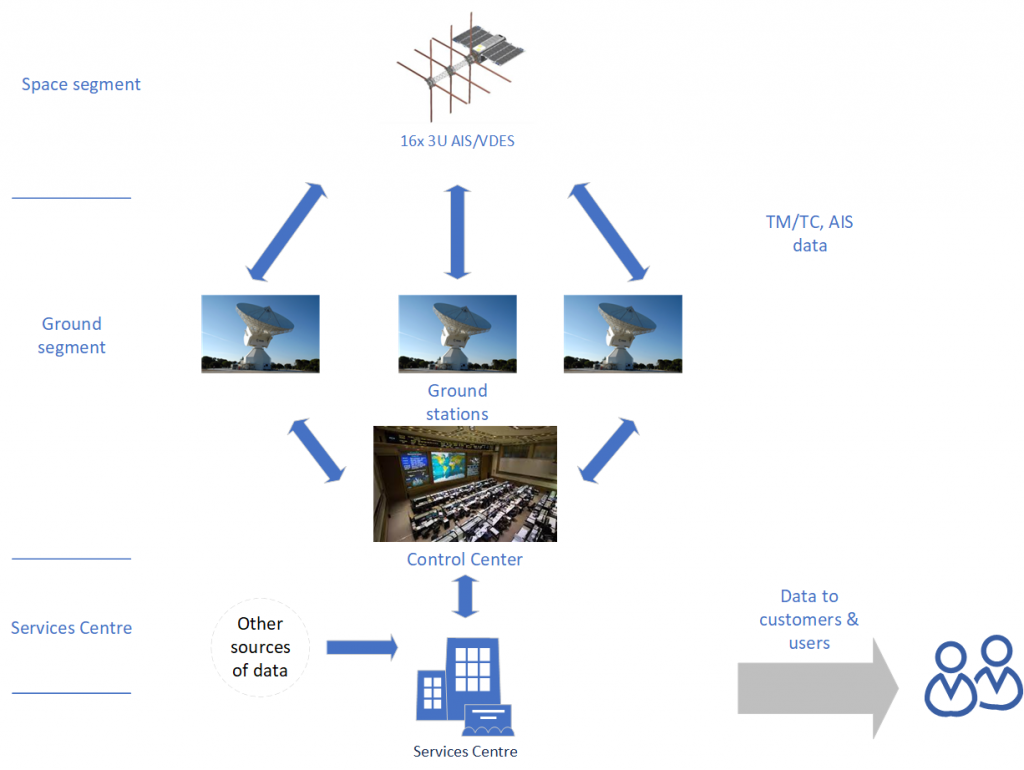
The end product are services and data to three segments of customers: Maritime Surveillance, Aquaculture & Maritime Environment and AIS. This is achieved by a space segment: 32 or 2 x 16 satellites, one type with AIS/VDES payload and other with a Hyperspectral camera. The ground segment is outsourced to increase focus and decrease time-to-market.
Imager (16 Hyperspectral sats)
AIS/VDES (16 AIS/VDES sats)
Added Value
The main added value for ATON project is combination of low revisit-times, hyperspectral imagery, AIS/VDES technology, and the novelty services that can be provided to Aquafarmers, that address the imensous fishery losses due to harmful algae bloom. The aggregated approach, which is based on near end-to-end vertical integration – from space segment to the services center – allows a control on the end product and possibility to customize it for the customers. It does not aspire to compete with large institutional satellite hyperspectral payloads, freely availalbe, but it can through DsaaS integrate different sources of data and provide images within 6h intervals. It is important to consider that the new generation Sentinel should be availalbe not sonner than mid 2030, therefore this activity time to market is an important factor.
In what regards the AIS data, the constellation provides data collected and controlled by a EU supplier (Lusospace), which is by itself a desired aspect, and has the potencial of capturing early adopters of VDES technology. VDES can alleviate the data strain on the AIS, and the international maritime community has started the steps to regulate the technology. This radio communication standard maintains the AIS functions while adding the capacity for larger data exchange. VDES establishes dedicated frequencies for bidirectional communication. Additional capabilities of VDES include autonomous shipping which will be a market disruption, leading to safer shipping and more fuel efficiency.
Current Status
De-risking activity concluded. Next steps being planned with ESA involvement.
Wildfires represent a growing global risk, driven by climate change and increasing in both frequency and intensity. They generate substantial CO₂ emissions, cause significant economic losses and impact critical sectors such as forestry, infrastructure, and carbon markets. Effective mitigation depends on timely detection, continuous monitoring and actionable intelligence.
Existing wildfire detection approaches, both ground-based and satellite-based, face limitations in scalability, latency and temporal coverage. In particular, current satellite systems exhibit a critical ‘afternoon gap’, a time window during which wildfire ignition and spread are most likely to occur but observation coverage remains limited.
To address these challenges, OroraTech has developed the Wildfire Solution (WFS), a scalable intelligence platform that integrates data from more than 25 satellite missions, combined with proprietary analytics and additional datasets such as weather and lightning information. The system supports the full wildfire lifecycle, including risk assessment, early detection, monitoring and post-fire analysis.
The objective of this activity is to further enhance this capability through the development and validation of proprietary satellite infrastructure. The FOREST-3 mission represents a key step in this evolution, enabling the acquisition of dedicated thermal-infrared data and reducing dependency on third-party sources.
By contributing to the development of a Minimum Viable Constellation (MVC), the activity increases revisit frequency, reduces detection latency, and improves temporal coverage, particularly during critical periods. This integrated space-and-service approach enables near-continuous monitoring and significantly enhances the operational value delivered to customers.
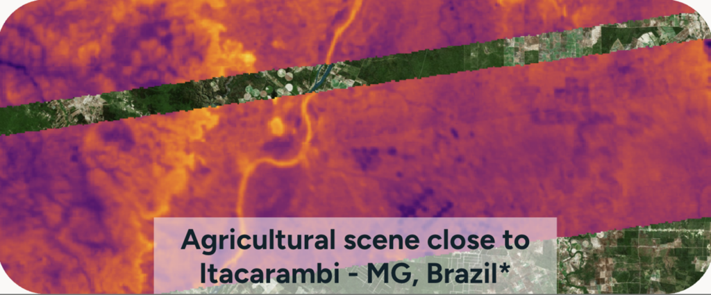
OroraTech FOREST-3 L1 image.
The activity’s objectives also extended into the insurance and finance sector, targeting underwriting, portfolio-risk monitoring and claims support. A technical-feasibility study found that OroraTech’s proprietary active-fire archive provides a clear advantage at the short-term (daily) horizon rather than at seasonal scale, shaping the Short-Term Fire Hazard (STFH) model, which measurably outperforms the industry-standard Fire Weather Index and directly serves insurers’ pre-event risk-assessment and claims-triage needs.
Customers and their Needs
The key customer segments targeted by OroraTech’s Wildfire Solution are in both the B2G (public) and B2B (private) sectors. Governments, fire services, commercial forestry companies, infrastructure and energy providers, insurance companies and environmental organisations represent the primary users of the system.
In the B2G segment, the solution supports operational needs related to early wildfire detection, real-time monitoring, and situational awareness, enabling efficient response and resource allocation. In the B2B segment, commercial forestry operators, infrastructure providers and insurers require reliable and timely data to protect assets, manage risk and support decision-making processes.
Across all segments, customer needs increasingly go beyond simple detection and include continuous monitoring, fire spread prediction, impact assessment, and integration into operational workflows.
The system is developed following a customer-centric approach, with key users actively involved in validation activities. Organisations such as SOPFEU (Canada) and the National Parks and Wildlife Service (Australia), together with other international stakeholders, provide operational feedback to ensure alignment with real-world requirements.
On the insurance activity: Dedicated customer discovery under the activity engaged insurance and reinsurance organisations. These engagements confirmed strong demand for pre-event portfolio-risk monitoring, claims-validation support and API-based integration into existing underwriting and claims platforms rather than a stand-alone GUI, directly shaping the insurance configuration of OroraTech’s Short-Term Fire Hazard (STFH) product.
Targeted customer/users’ countries
Wildfires are a global phenomenon affecting all continents. OroraTech’s Wildfire Solution is designed as a fully scalable global service, supporting customers across more than 25 countries and monitoring hundreds of millions of hectares worldwide.
The forestry/insurance-sector configuration is in operational production for Australia, Brazil, California, Chile, Greece and Uruguay, with pilot datasets prepared for Colombia, the Iberian Peninsula, Idaho, Serbia and Zambia.
Product description
OroraTech provides a vertically integrated Wildfire Intelligence-as-a-Service (IaaS) solution, combining its Wildfire Solution platform with proprietary thermal-infrared satellite data. By integrating multi-source satellite data with its own constellation, including the FOREST-3 mission, the system significantly improves detection latency and temporal coverage, particularly during critical periods such as the afternoon gap. This results in faster and more reliable wildfire detection and monitoring, while demonstrating the viability of combining proprietary nanosatellite data with existing sources to deliver a scalable, low-latency global service.
Short-Term Fire Hazard: This platform was extended with the Short-Term Fire Hazard (STFH) model, 1 km-resolution ignition-likelihood forecast updated every 4 hours for the insurance sector, delivered through the WFS interface and via OroraTech’s STAC catalogue for direct integration into underwriting, claims and GIS systems.
Added Value
OroraTech’s solution differentiates itself through a fully integrated, end-to-end approach combining proprietary space-based data with advanced analytics and a customer-focused service. The Wildfire Solution aggregates a large number of satellite data sources on a global scale, complemented by proprietary thermal-infrared data, resulting in reduced detection latency and enhanced monitoring capabilities.
Fast alerts and updates are automatically delivered to users for their areas of interest, enabling efficient deployment of fire suppression resources. Advanced features such as hotspot fusion across multiple data sources, fire spread modelling and the integration of environmental data layers (e.g., weather and wind) provide comprehensive situational awareness. In addition, the system incorporates non-space data sources, such as ground-based sensors and cameras, further enhancing detection accuracy and operational value.
From a technical perspective, the proprietary payload is based on a miniaturised multispectral thermal-infrared imager, optimised for CubeSat platforms and capable of sensing both mid-wave and long-wave infrared radiation. This enables reliable detection of high-temperature events such as wildfires. To further reduce latency, onboard GPU-based processing allows for in-orbit detection, while optimised communication architectures support rapid data delivery.
Compared to non-space-based solutions, the system provides significantly higher scalability and cost-efficient coverage of large geographic areas, ranging from regional to global scale. Continuous customer feedback and validation ensure that the solution remains aligned with operational needs and evolving market requirements.
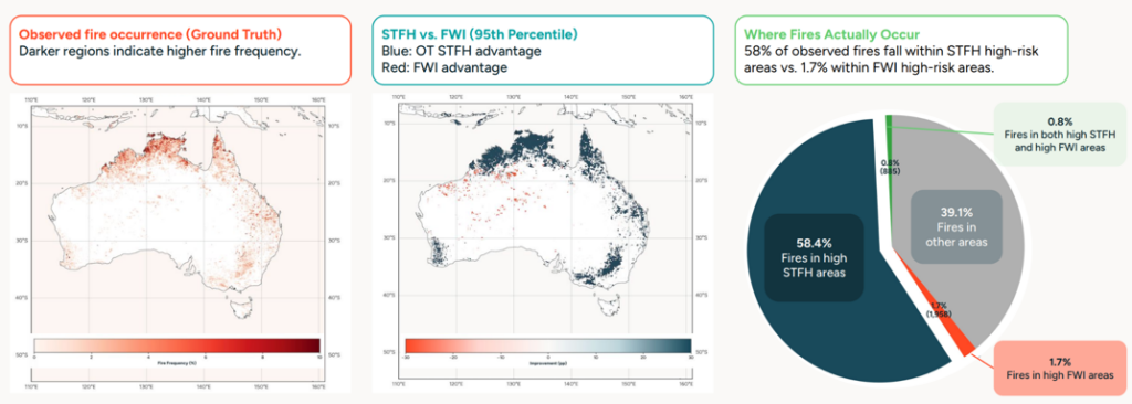
Insurance Activity: OroraTech quantified this advantage for the insurance use case. Benchmarked against the industry-standard Fire Weather Index (FWI) across Australia, Brazil, California and Greece, the Short-Term Fire Hazard (STFH) model achieved PR-AUC improvements ranging from 5-fold to 42-fold. In an exemplary continental-Australia evaluation, 58.4% of observed fires fell within STFH high-risk areas at the 95th percentile, compared with only 1.7% for FWI, directly addressing insurer feedback that weather-index outputs do not translate reliably to observed fire occurrence.
STFH vs. FWI performance benchmark, continental Australia (FOREST-3 Insurance Activity).
Current Status
OroraTech has successfully demonstrated a fully integrated wildfire intelligence system combining space, ground and user segments. The FOREST-3 mission represents a major milestone as the company’s first fully in-house developed end-to-end satellite system. The satellite has been successfully launched, commissioned and validated in orbit, demonstrating robust platform performance and operational wildfire detection capabilities.
Validation activities have confirmed the stable operation of core subsystems, including power, thermal, communications, and attitude control, as well as the successful acquisition of thermal-infrared imagery in both mid-wave and long-wave infrared bands.
The mission further demonstrates the flexibility and robustness of OroraTech’s system architecture, where optimised data processing pipelines and communication strategies ensure reliable and timely delivery of wildfire information to end users. From a service perspective, FOREST-3 operates as an integrated data source within the Wildfire Solution, supporting near-real-time wildfire detection and continuous monitoring capabilities.
Commercially, the system has demonstrated strong market traction, with a growing global user base, large-scale monitored areas and multiple high-value contracts across government, forestry and insurance sectors. Overall, the activity confirms both the technical feasibility and commercial viability of OroraTech’s vertically integrated wildfire intelligence service and establishes a solid foundation for scaling the satellite constellation and expanding global service coverage.
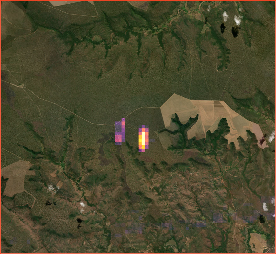
First fire detection with Forest-3
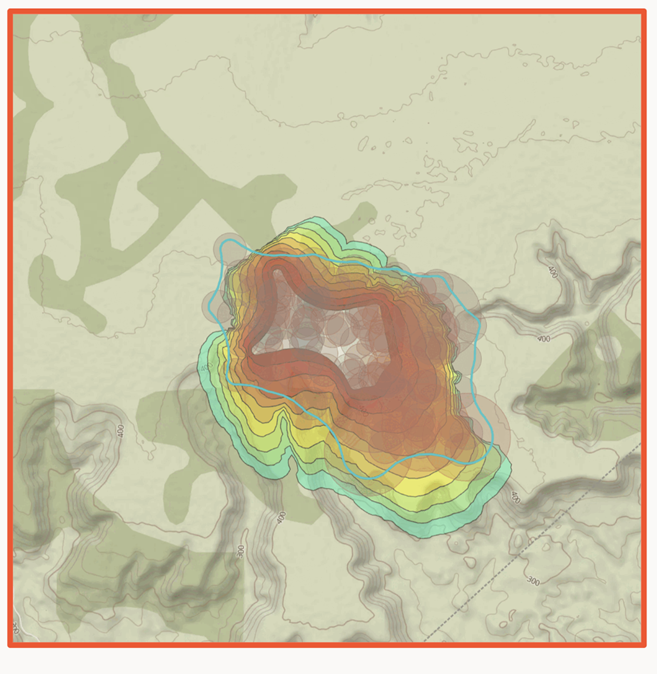
OroraTech FireSpread simulation (rainbow-colored progression) initiated on FOREST-3 detections (white) & final satellite-detected affected area (turquoise).
Insurance Activity Status at Final Review: The Short-Term Fire Hazard (STFH) model reached Final Review in June 2026 as a working, customer-facing product. It is in operational production for six regions (Australia, Brazil, California, Chile, Greece and Uruguay), accessible via the WFS interface and STAC catalogue and validated with multiple forestry and civil protection end customers.
The integration of Short-Term Fire Hazard was intended to strengthen the product-market fit of OroraTech’s wildfire intelligence suite and support the company’s market entry into the insurance sector. This hypothesis was validated through a one-year pilot with an insurance risk intelligence platform serving insurance companies with natural catastrophe risk solutions. As part of the pilot, OroraTech integrated its wildfire product suite into the risk platform, enabling insurers to assess portfolio-level wildfire exposure and access fire risk intelligence before, during, and after wildfire events.
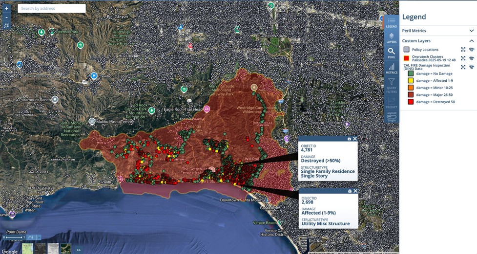
OroraTech integrated into an Insurance risk intelligence platform to visualise impact of fire to monitored assets.
FIbEO aims at helping product traceability by obtaining yield forecasts to use in verifying product origin and guaranteeing food quality. It also helps to monitor agricultural practices and compliancy with product specifications.
Customers and their Needs
Agri-food industry: checking compliancy of product consigned by outgrowers.
Consortiums: support their member demonstrating compliancy to specifications, improve brand awareness Control bodies: improve check capabilities, speed up compliance certifications.
Targeted customer/users countries
Producers Organization (Consortium), Growers Group-PO; Control bodies-CB, Agri-food industry-AGIND.
Product description
FIbEO makes use EO, field data and scheme rules to produce better yield estimates of raw materials and help cross-checking this information with real consignments. The service shall help creating trustworthy food supply chains and ensure integrity while tracing provenance.
Added Value
(PO) Avoid over consignments, improve growing and profitability for associates, Ensure the compliance to product specifications, Have a more transparent information flow, Improve perceived quality of the product, Enable immediate corrective actions, Track production lots, Reduce certification time; (CB) Reduce time during audits, Automated digital cross-checks; (AGIND) Full traceability, Brand recognition, Immediate corrective actions, Dissuaded misbehaviour, Avoid frauds, Centralised information system.
Current Status
The project has reached its last Milestone, with the pilot service being fully developed and functional. The historical data from wineries have been collected to train the coded models, which are now running and providing estimations nurturing FIbEO dashboards.
The platform access has been granted to partnering companies, receiving their feedbacks from real scenarios, tuning the product and refining the next commercial steps.
The final review has been held on May, 2023.
Concerning the commercial roll out; our main intent is to upsell to existing customers while on-boarding new ones, the values in the financial workbook are based on such average price and size: the sales are hectare-based and we foresee to cover/reach 100.000 hectares in the first commercial year, 200.000 for the second and 300.000 for the last one.
Existing customers of ABACO 4 grapes are potential customers of FIbEO service. The project has already been presented to some of them, gaining interest from another Consortium in Italy; it also received a positive feedback from a Producer Organization in the north, and other wineries in central Italy outside of the Chianti Classico area.
This means that the model will have to be trained following the specific area’s characteristics, but also that once the platform has been set up, it can deliver a useful service for viticulture in general and not only for the Chianti Classico area used as a case study.
Next steps: to acquire new customers we will create a solid value proposition per customer segment where we can use the current attention to supply chain traceability, resilience, origin of healthy food, quality assurance of high value products like wine and olive oil amongst others. , We expect an increased demand to our FIBEO proposition based on new more strict EU policies and laws: The EU Deforestation-Free Regulation (EUDR) and the Corporate Sustainability Reporting Directive (CSRD).
We will set-up targeted marketing campaigns for the different customer segments for different countries/markets in order to build new customer relationships.
The investment in EODDL is part of SENER Aeroespacial’s corporate strategy pillars of SENER roadmap for space communications. This decision is followed the relevant achievements reached in ESA science missions where SENER Aeroespacial is consistently delivering steerable antenna subsystems as well as RF equipment.
Customers and their Needs
During last decades, institutional and private European Space actors have contributed to create an important and growing Earth Observation (EO) sector. EO market is nowadays undertaking a rapid transformation towards large constellations and the use of next generation sensors and advanced payload.
This potential increment in the number of satellites to manage, the data volume to handle, together with the current congestion of the commonly allocated spectrum, are pushing to find frequency band alternatives and the use of new technologies to support higher data rates. In that context there is a trend encouraging the use of the 26 GHz spectrum (25500-27000 MHz) for payload data transmission in Low Earth Orbit (LEO) missions. Consequently, an evolution in the communication architecture of future planned EO satellites is required in order to deal with the expected big increase in the volume of data to be downloaded.
Thus, the shift to the 26 GHz band will provide 4 times more available bandwidth. However for its optimal use, especially at very low elevation angles, there is a need for highly directive (thus steerable) antennas and advanced coding and modulations schemes to cope with the highly variable atmospheric attenuation.
Taking advantage of that situation, SENER Aeroespacial is proposing the development of a full X and K-band EO Data Downlink System (EO-DDL). It is a robust high throughput downlink system for LEO satellites targeting data rates higher than 2.6 Gbps per channel.
Targeted customer/users countries
Earth Observation satellite missions. Worldwide.
Product description
Based on an unique reconfigurability within the baseband processing and operational frequency as well as the integration of a compact and steerable dual-band antenna, the system will maximize the average data throughput in every GS contact.
Additionally, the inhered interoperability due to the capability to operate in both X and K band will allow the contact with the majority of the current and future GS as long as there is still a limited deployed ground infrastructure available with 26 GHz capability.
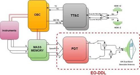
In order to build the complete downlink system, SENER Aeroespacial is proposing a novel concept where two main on-board sub-systems are identified (Figure 1‑2):
Payload Data Transmitter (PDT) assembly, built around baseband modules as well as RF parts (e.g. the up-conversion and power amplification) suitable to support both X- and K-band signals.
Dual Band Steerable Antenna (DBSA) assembly, with the proper combination of dual-band units (e.g. reflector, feed), band-specific units (e.g. waveguides), pointing mechanism and pointing mechanism electronics.
EO-DDL simplified system context diagram
This concept, together with the consortium and the associated work plan are the result of a careful balance of reusable design and innovation aiming to develop an European, highly integrated, robust, reliable and flexible (dual-band) solution to enable the use of very high-rate sensors and payloads required for the upcoming Earth Observation (EO) missions.
Therefore, the key features and functionalities are:
Reconfigurable: with the capability to manage different frequency bands (operation in X/K), different bandwidths and several Coding & Modulation schemes in a flexible and reliable manner. In this way, it maximizes the number of applications and available GS to link towards as well as the average data throughput during a contact.
High speed: capable of internally managing extremely high data rates and transmit the data at high speed to the Ground (higher than 2.6 Gbit/s per channel).
Availability and robustness: ensuring high-speed data transmission from low elevation angles, independently of the GS location and weather conditions
Compactness: the implemented compact and scalable design will allow its implementation in different kind of missions, including small spacecraft’s.
Scalability: This concept can be scaled in a future development by integrating a PDT and a TTC transceiver in a single unit operating in K- and X-band respectively
The proposed development activities aim at achieving the TRL5 for the critical technologies identified in this proposal, within the time frame defined here as well (Q4-2021). The TRL status reached and the time window proposed are relevant since the second purpose of this activity is to allow reaching TRL-6 of the integrated critical technologies in a relevant environment, for late Q2-2022.
The proposed development is the continuation of a previous phase A already completed under ESA contract No. 4000124352/18/NL/FF/gp: “Feasibility of a full X and K-band EO Data Downlink System”. This project has been successfully completed.
The outputs of this project will be used as inputs for the proposed INCUBED activities, where it is foreseen to design, manufacture, assemble and test the Payload Data Transmitter (PDT) EM and detail the development plan for the different components of the system up to achievement of space qualification (EQM).
Added Value
EO-DDL maximizes the number of applications and available GS to link towards as well as the average data throughput during a contact.
Current Status
This Incubed activity has been completed on Q3 2023.
The use of solely Earth Observation, helps to derive actionable insights for many of the new business applications. With more and better EO-data by now we succeed in monitoring a very large number of outdoor objects and inform customers on relevant changes. However even when using the newest very high resolution optical and radar sensors, there is lack of validation or comments by a human. By assimilating existing quality checked (open) data like crowd sourced data and official texts (e.g. permits), we can add significant value to EO-derived information in e.g. urgency, context and implications. Through SINERGI we add value to the changes we detect on EO-data with information from Big data sources by using technology for semantic integration and object ontology standards.
Customers and their Needs
Everything changes continuously on this planet. So, information outdates quickly. Causing poor decisions and misfit actions. Our clients, who make the transition to data driven decision making and data driven business, need up-to-date, complete and reliable information to follow environmental, social and corporate governance (ESG). Many policy and businesses applications lack data and actionable insights to make the right decisions to follow ESG.
Targeted customer/users countries
The key customers segments targeted by our product are the value added service customers like Forest Law Enforcement (Nature Protection Law Enforcement), urban green and tree management, environmental Inspection Service and building Insurance.
Product description
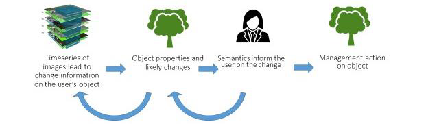
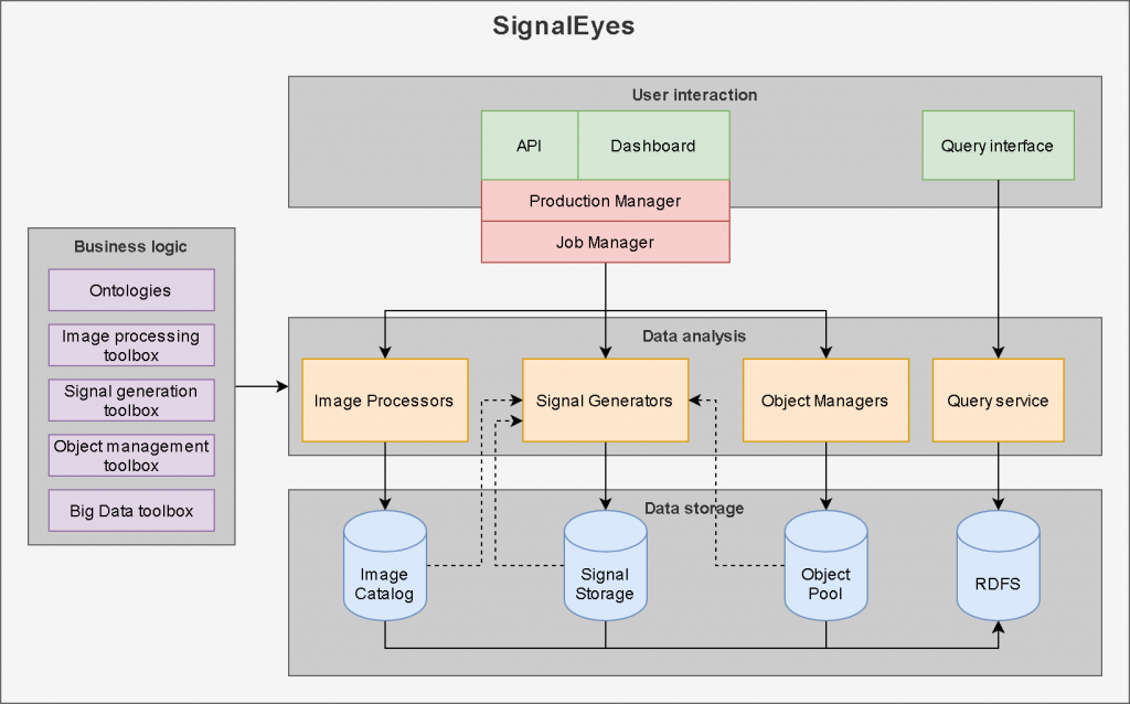
In recent years, NEO developed the SignalEyes platform for Earth Observation (AO) based nationwide information services. The figure belo shows the SignalEyes method of information provision with EO data and its learning element.
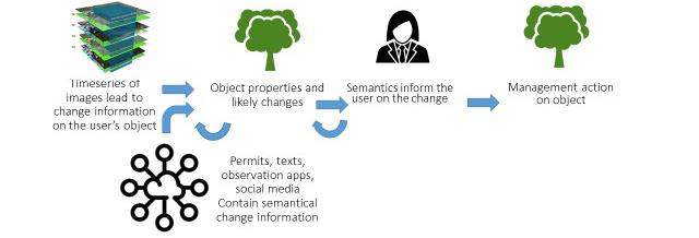
In SINERGI we developed an ontology based method to use Big Data to add value to earth observation data and apply/test it to monitoring of trees, shrub, invasive plant species and buildings. The solutions rely on the existing SignalEyes infrastructure, a system that enables the monitoring of geographical objects using EO data for changes relevant for a wide range of applications.
The role of the SINERGI solutions in the context of the overall system of its target users is to provide the necessary insights on properties of objects on the Earth’s surface based on the most recent relevant data extracted from EO and non-EO data sources.
The components and component elements that will be developed in SINERGI provide the SignalEyes system access to a much wider range of data sources, allowing cross-checking of data-derived insights from multiple angles, leading to more reliable, more complete and more up-to-date information.
SINERGI method of information provision to a userOverall SINERGI architecture
Added Value
The semantic integration of Big data using ontologies is a step that is still new to the EO-services development. The added value of an EO product increases very significantly, when this integration is achieved successfully. In the described services, the value of the EO-service increases by an estimated factor of 3-5. The value of sales to our current customer base may multiply. Much of our services are limited to The Netherlands. However NEO is an EARTH observation services company, working on 4 continents and with an increasing focus on international markets.
Through SINERGI earth observation data will be more used in business applications. Data that is now by itself not directly fit to derive actionable insights for certain customers, become valuable when combined with other data. When competitors adopt similar working methods it is likely that EO-based services as a whole become more valuable leading to sustained or increased growth (as generally predicted for the value adding sector). In our data driven world, earth observation data, if combined with other data, will play a bigger role in providing better information resulting in better decisions for a better planet.
Current Status
The SINERGI activity started in September 2021. For SINERGI-derived SignalEyes services there are potentially hundreds of use cases and as many customer segments. In order to structure our activity, we selected 4 use cases, that illustrate the scope of services:
Mutation signals on buildings enriched with ‘building permit’ information from public sources for commercial and government customers
Enriching vegetation objects with species information from citizen science observations for urban green and nature management purposes
Mutation signals on trees enriched by ‘Tree Felling Permits’ from public sources for law enforcement
Mutation signals on rapid vegetation development in canals enriched with citizen science’ notifications on Invasive Exotic Species for water management authorities
We have successfully tested these use cases resulting in significant added value to EO-derived information. First contracts and cooperation have emerged from our activities. Many opportunities will be further developed in the coming years. We could not have achieved this so quickly without the support of the ESA InCubed program and support of the Netherlands Space Office.
Connecting satellites to additional ground station networks involves high integration costs in terms of time, personnel, and licensing. The market remains fragmented due to diverse providers, locations, and legal constraints, making real-time radio communication with satellites impossible. Meanwhile, some ground stations remain underutilised, and satellite integration remains complex.
The Aggregated Marketplace for Ground Station Services seamlessly integrates standalone ground stations, along with virtual and physical networks, into a unified ecosystem. It allows users to book services, manage contacts, and communicate with satellites within a single cross-network environment. Its role within the broader system of its target users is to serve as a satellite communications platform, leveraging ground station services from available providers while optimising operations based on user-defined constraints.
Gains for Satellite Operators:
Pre-integration with multiple ground station networks, reducing integration time
More communication sessions with satellites within the same mission budget
A single gateway for booking and scheduling satellite contacts across a combined network
Wider coverage and lower latency
Gains for Ground Stations:
Additional sales channel
Increased efficiency through reduced integration costs
Pre-integration with mission control platforms
Customers and their Needs
The Marketplace customers are satellite operators, manufacturers, mission owners, system integrators, academia.
Their needs are related with:
Reduced latency and expanded contact options
Reliable infrastructure
Simple integration and usage
Higher level of automatisation
Interoperability of different systems
Lower costs
Targeted customer/users countries
Worldwide
Product description
Features of the Aggregated Marketplace for Ground Station Services:
Cross-network connectivity
Aggregation of services and pricing from different providers
Contact management and booking across multiple ground stations
Optimised booking based on various criteria
Unified user interface for all key functions
Vision: Near real-time data transfer capability
Added Value
There is a shortage of single, one-point-of-entry ground communication solutions integrated with multiple ground station networks. The closest alternatives are virtual networks, which combine stand-alone ground stations rather than full networks and lack mission control and satellite operations simulation capabilities like those offered by the Spaceit software.
Spaceit’s solution unifies satellite operators and ground station networks into a single platform. It integrates both virtual and physical networks—comprising radio and optical ground stations—creating a cohesive ecosystem for ground station services. This platform enables users to book and manage contacts, as well as communicate with satellites, all within one environment.
Current Status
The activity was successfully completed, and the service has been operational since 2025. During the InCubed programme, Spaceit integrated the software platform with six ground station networks, developed additional platform features, and signed commercial customers. The most notable mission, OPS-SAT ORIOLE, set to launch in 2026, will demonstrate near real-time switching of high-speed radio communications across different ground stations, among other objectives.
Make a list of six Sentinel-1 analysis ready data (ARD) products that are very easy to use for both human visual and machine-readable form. The idea is either one-click or one Application programming Interface (API) command integration and use. Make the most of Sentinel-1 input data with state-of-the-art calibration, thermal-noise removal, and speckle suppression. The S1 ARD products are targeted for several governmental and business users to help them in certain use cases as a useful input for analysis or to provide an end-user service.
The goal under CCN3 was to enable users to seamlessly subscribe to the Synthetic Normalised Difference Vegetation Index (SNDVI) API services and begin using them without requiring any human intervention from KappaZeta’s side. The service should be designed to automatically scale in response to demand, ensuring that it can handle varying levels of usage efficiently. At the same time, the service should be optimised to keep storage and processing costs to a minimum, making it cost-effective for both KappaZeta and its customers. Additionally, a sandbox environment should be provided where customers can try out the services, allowing them to explore and test the capabilities of the product.
Customers and their Needs
Customers:
EO, ICT, and GIS companies as service providers for various end-user services,
governmental users,
farm management software (FMS) providers, .
agricultural enterprises and cooperatives,
stakeholders in carbon bio-sequestration (biological carbon sequestration, e.g., in agriculture, forests, peatlands, wetlands, and grasslands)
Needs:
To integrate and use satellite imagery and use value-added satellite products characterising vegetation dynamics quickly and easily.
The models serving an end-user require well-calibrated and high-quality SAR data
End-users require frequent updates about their areas of interest
End-users require imagery with high spatial resolution
Developing an accurate cloudless Normalised Difference Vegetation Index (NDVI) requires well-calibrated and high-quality Synthetic Aperture Radar (SAR) data.
Targeted customer/users countries
European, South and North American, and Asian countries
Product description
Sentinel-1 Analysis Ready Data (ARD) layers:
Time series of parcel-level statistics of VH and VV backscatter, VH/VV backscatter ratio, VH, and VV 6-day repeat pass coherence (parcel min, max, mean, median, standard deviation)
Calibrated high-resolution VH and VV coherence rasters
Calibrated high-resolution VH and VV backscatter and VH/VV ratio rasters
Multi-polarisation backscatter image for visual use as a WMS service
Synthetic Sentinel-2-like natural colours image based on Sentinel-1 data, using modern AI-modelling tools
Synthetic NDVI-like raster based on Sentinel-1 and -2 time series with AI-modelling
The idea is to make satellite image accessible with one click or one API command (e.g., switch on the satellite WMS/WCS layer in your web/desktop GIS and data mining, machine learning frameworks). All the data layers will have state-of-the-art calibration, thermal noise removal, and speckle suppression.
Under CCN3, the new product will offer the following features over the current sNDVI service:
Improved accuracies of sNDVI on 12D coherence (Sentinel-1) inputs
Automated sNDVI raster creation via API calls
sNDVI parcel statistics timeseries
Updated web map sandbox showcasing sNDVI for end-users and prospective customers
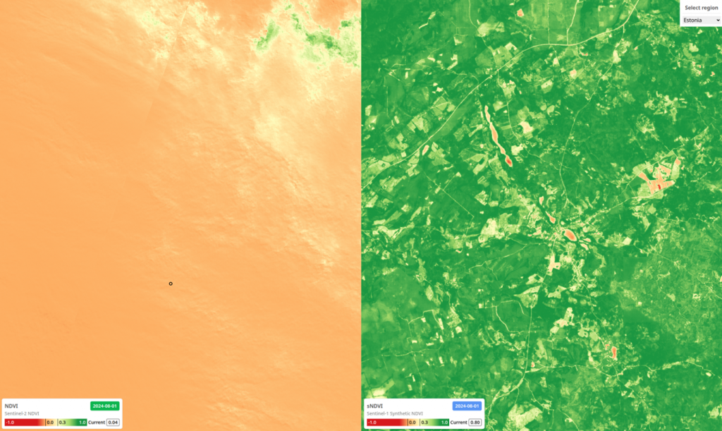
The image on the left displays a cloudy NDVI image over Estonia from 1 August 2024, while the image on the right shows the corresponding SNDVI for the same date and location.
Added Value
The pre-processing burden of SAR data is taken away. A lot of EO, GIS, and ICT companies and government institutions are not SAR experts, but they would benefit a lot from SAR data if it were provided in analysis ready format. In addition, utilising Synthetic Aperture Radar (SAR)-based biomass monitoring provides consistent and accurate data unaffected by cloud cover. This enables agricultural experts to navigate changing conditions with greater confidence and agility, regardless of weather patterns.
Current Status
KappaOne has three interactive demo environments deployed, where users can observe fresh and historical Sentinel-1 data layers together with parcel statistics and synthetic NDVI:
The provided raster images illustrate KappaZeta’s vision of high-quality, high-resolution Sentinel-1 images that are processed to be useable for visual interpretation as well as for machine learning input. Visual interpretation is helped by the highest reasonable resolution, 5m grid cell, state-of-the-art speckle filtering method “Refined Lee”, careful contrast enhancement, and a selection of composite images.
As an advanced feature, temporal averaging can be selected to show cleaner, more detailed images. Despite all the efforts, direct interpretation of Sentinel-1 images is still challenging for non-trivial cases, so we also provide a synthesis of Sentinel-2 and Sentinel-1 images, which can provide an NDVI-like vegetation index for cloudy days. As a third product, we can deliver parcel-based time series of Sentinel-1 data, which uses a special parcel level noise reduction mechanism and is able to give a better signal-noise ratio than simple polygon extraction from the raster. All these products can be ordered via an API, which allows registered users to define new areas of interest, time period, list of parameters, set up a web map, generate download links, etc.
Under CCN3, several improvements were made to the previous sNDVI service offered under KappaOne. Key updates include:
Enhanced sNDVI model accuracy based on 12-day coherence from Sentinel-1 data.
Development of an automated sNDVI raster creation process via API calls.
Availability of parcel-level sNDVI time series statistics accessible through the API.
In addition, a web map platform was deployed as a sandbox environment for end-users and potential customers to explore SNDVI capabilities. The platform is accessible via:
The web map provides sample SNDVI data for six countries—Brazil, Estonia, Colombia, Latvia, Lithuania, Germany, and France. Users can upload parcel geometries in GeoJSON format to explore SNDVI values and generate time series for regions with available precomputed data.
Climate change and geopolitical tensions are challenging our food security, environment, and national safety. The Hyperfield satellite constellation, combined with AI-based analytics, provides global, continuously updating, and actionable near real-time insights and alerts for timely action. Building a resilient society will be possible with gapless monitoring and automated processing of data in orbit and on ground.
Customers and their Needs
Hyperfield helps food producers, businesses, and governments obtain timely information to make effective decisions towards safety and security, sustainable agriculture, and mitigation of climate change risks.
Targeted customer/users countries
The service is global and targets primarily agriculture, aquaculture, blue carbon, crop insurance, defense, and security sectors.
Product description
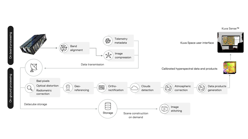
Hyperfield combines a constellation of hyperspectral small satellites, ground segment and advanced AI/ML-based analytics to provide actionable insights to customers and end users.
The first-generation satellite for the constellation is developed jointly in this project by Kuva Space and the VTT Technical Research Centre of Finland. The 6U CubeSat carries a novel in-orbit tunable high-resolution hyperspectral imager covering visible to near-infrared wavelengths. Future satellite generations will cover short-wave infrared wavelengths by including additional imaging channels.
The mission operations are performed from Kuva Space’s mission control and ground station in Espoo, Finland, and through a third-party ground station network provider. The downlinked hyperspectral data is processed on ground to validate its usability to the selected customer and end-user applications. Advanced AI/ML-based hyperspectral data processing and analytics are developed concurrently with the project. The eventual satellite constellation will be launched after the validation mission and consists of tens of small satellites providing up to daily revisits to selected areas of interest.
Added Value
Current hyperspectral offerings are delivering data based on tasking, where data processing is done manually. Kuva Space’s solutions aim to provide hyperspectral-based information-as-a-service at an affordable annual licensing fee. The company aims to make hyperspectral imaging data and insights more accessible by automating the data-to-insights processing with AI.
Current Status
Two Gen 1 satellites have been launched successfully and are operational. The data from these satellites is used to run customer pilots globally and to develop and train Kuva Space’s AI models. Work is underway to launch two Gen 2 satellites in 2026, bringing in-orbit processing capabilities.
Going further than just producing water quality data, the EOSmart solution is capable of transforming global water quality data into actionable information. This massively simplifies data access for water managers, allowing them to condense data to business-relevant information and integrate EO-based measurement in routine operations.
Customers and their Needs
Customers are starting to include data sources such as remote-sensing data, but need to manage the increasing data volumes up to analysis, and report it in a more efficient way.
An easy-to-use web interface allows the customers to quickly gain an overview of the water quality in their water bodies and areas of interest in coastal regions. Comparison to in-situ measurements and the fast information about thresholds being exceeded are crucial to react to unwanted developments in the respective water bodies. Statistical analysis tools for longer time series are needed to comply with reporting duties on the water quality of lakes and rivers.
Targeted customer/users’ countries
EOSmart is useful for customers all across the globe, as the smart analytics and services are location-independent.
A specific focus is set on:
Water authorities (e.g. bathing water monitoring and alert)
Water Industry (e.g. coastal construction)
Product description
The EOSmart product and services are tailored water quality information on a global scale, from novel very-high to high spatial and temporal resolutions, served in the most automated and customer-oriented way through a commercial online platform.
The provided services are
Baseline analysis: the satellite images range back years to decades and enable us to provide a sound analysis of long-term trends and seasonality
Monitoring: daily updates of the current state of any water body in the world
Alert: automatic notifications when user-defined thresholds are exceeded
Added Value
Water quality information at your fingertips – easy and super-fast access to global water quality information. Dashboards and analysis tools transform the data into actionable information and can support decision making (e.g., an environmental agency closing a lake due to high and rising cyanobacteria observations).
Current Status
The final product “eoApp AQUA” was launched in May 2024 and now serves customers around the world. A marketing campaign and sales forces are part of the ongoing go-to-market activities to grow the market share in the close future.
The objective of the GEMSTONE product is to apply our proprietary state-of-the-art Artificial Intelligence / Machine Learning algorithms on Copernicus’ Sentinel-1 & Sentinel-2 satellite imagery to provide our customers with actionable insights on various industries. All insights will be then displayed on a user-friendly online platform.
Customers and their Needs
The key customer segments targeted by our product are as follows: banks, hedge funds, insurance companies, governmental institutions, the automotive industry, and the energy sector companies. Since GEMSTONE is planned as a very universal product, there are the following three common problems shared by all customer segments. The first of our customers’ problems is, that they currently struggle to obtain actionable insights on particular segments in a timely manner. Utilizing satellite data, the time period from an observable phenomenon happening in a particular industry, to our customer having an actionable insight, shortens rapidly. The second problem of our customers’ problems is, that they cannot fully rely on the data they use for economic indices creation. The data can be easily biased by governments, industry companies, or any other stakeholders. On contrary, the satellite imagery is an unbiased information source by nature. The last of the major problems our customers face is the accessibility of actionable insights. Currently, analysts have to actively search for the information, using a wide spectrum of data sources. With GEMSTONE, all necessary information will be accessible on a single online platform.
Targeted customer/users countries
Targeted customer segments and their needs are described in the previous section. Product description. There are already existing customers using our GEMSTONE product that are providing valuable feedback to further development. To name a few: JP Morgan Economic Research Department, Credit Suisse, Bridgewater, Exxon, or Deloitte.
The nature of our product allows us to make the solution fully scalable and sell to customers anywhere on the planet Earth.
Product description
SpaceKnow’s GEMSTONE (Global Economy Monitoring System delivering Transparency and Online Expertise) aims to develop an easy-to-use and scalable platform providing insights on the performance of selected industries and commodities supply chains based on indices computed with state-of-art algorithmic solutions on satellite imagery. With our GEMSTONE the customer will be able to get instant access to both location-specific knowledge as well as country-wise or industry type aggregated information that allows users to query activity at a ‘topic’ level (coal facilities, oil wells, etc). Clients can also provide locations of interest (e.g. the points of a specific company or product supply chain) and SpaceKnow data can be accumulated at those locations.
The key customer segments targeted by our product are as follows: banks, hedge funds, insurance companies, governmental institutions, the automotive industry, and the energy sector companies. Despite the fact that GEMSTONE is a very universal product, there are the following three common problems shared by all customer segments. The first of our customers’ problems is that they currently struggle to obtain actionable insights on particular segments in a timely manner. Utilizing satellite data, the time period from an observable phenomenon happening in a particular industry, to our customer having an actionable insight, shortens rapidly. The second problem of our customers’ problems is that they cannot fully rely on the data they use for economic indices creation. The data can be easily biased by governments, industry companies, or any other stakeholders. On the contrary, satellite imagery is an unbiased information source by nature. The last of the major problems our customers face is the accessibility of actionable insights. Currently, analysts have to actively search for the information, using a wide spectrum of data sources. With GEMSTONE, all necessary information will be accessible on a single online platform.
Added Value
The added value of GEMSTONE is practically demonstrated on the three of our customers’ main problems and their solutions in one of the previous sections. The main added value is thus in the provision of unbiased and timely actionable insights, in a user-friendly manner.
Current Status
The GEMSTONE project has come to an end. SpaceKnow has finished the development of the machine learning-based economic indices derived from satellite data, mostly from European Sentinel satellites.
SpaceKnow is happy to announce that all defined objectives of the project have been met. The quality of the final product has been evaluated and approved by stakeholders from industry, who will be the users of the product. The evaluation of the final product was very positive and that is one of the reasons why the development of GEMSTONE will continue throughout the following months. Based on market research and the latest global developments, new features and indices will be added, for instance, an algorithm for detection of ships on Sentinel-2 imagery, which enables better supply chain monitoring, a critical feature for many due to the recent global supply chain crisis.