ESA Φ-lab and World Food Programme launch joint innovation initiative

The EO & AI for SDGs Innovation Programme is now open for submissions. Launched by Φ-lab together with the World Food Programme Innovation Accelerator, the initiative aims to find Earth observation and Artificial Intelligence-based solutions to global hunger issues.

In a world where we produce enough food to feed everyone, there are 811 million people – or 10% of the global population – that still go to bed hungry every night. The COVID-19 pandemic, climate change and the complex social-economic landscape only serve to make the situation more dire, but as a counterpoint to this daunting backdrop, advances in space, satellite and Artificial Intelligence (AI) technologies have radically transformed humanity’s ability to observe and model the Earth’s systems.

This then begs the question of how Earth observation (EO) and AI can help solve global food crises. To find an answer, Φ-lab and the World Food Programme (WFP) Innovation Accelerator are joining forces to launch the EO & AI for SDGs Innovation Programme. The initiative will seek out cutting-edge innovations that use EO and AI technologies to address the challenges that WFP faces in its operations, while striving for business viability and industry leadership.

Read the full article at wfpinnovation

InCubed and SENER Aeroespacial’s EO-DDL development continues apace

Eight months after kick off, the EO-DDL payload data transmission system is currently undergoing prototype construction. Designed to meet the downlink requirements of tomorrow’s Earth observation satellites, the InCubed co-funded activity is well on the way to reaching a key Technology Readiness Level milestone.

With the rapid transformation of the Earth observation sector, satellites are increasingly being launched in large constellations with payloads of next-generation sensors producing considerable volumes of data. This presents significant challenges for data transmission, as the growth in spacecraft numbers leads to congestion of frequency bands and current hardware struggles to keep up with payload data-rate requirements.

ESA has proposed to alleviate the problem of overcrowded airwaves by moving the frequency range for sensor data from the X-band (8.025-8.4 GHz) to the K-band (25.5-27 GHz). While the K-band has the advantage of a greater bandwidth, it does bring its own challenges, such as requiring highly directional beams and complex signal modulation to cope with the infamous ‘rain fade’ effect.

Responding to these trends and technical requirements, SENER Aeroespacial is developing a bespoke, future-proof solution for satellite-to-ground-station data transmission: the Earth Observation Data DownLink system (EO-DDL). The EO-DDL consists of a Payload Data Transmitter (PDT) unit in tandem with a Dual Band Steerable Antenna (DBSA) assembly. The system can transmit in both X and K-band and will handle data rates of over 2.6 Gb/s per channel.

Building on a feasibility study it previously carried out for ESA, SENER is now working under an InCubed contract to develop the product further. “Collaborating on this InCubed activity is an exciting opportunity for SENER, as it will enable us to meet the increasing demands for high-throughput LEO-to-ground communication in institutional and commercial EO markets. We’re very happy to contribute to cross-fertilisation within ESA by extending the experience we’ve gained in the Science Programme to Earth observation. We’re also hoping to agree strategic partnerships as a result of the development, with several satellite manufacturers already showing interest in the proposed product line,” commented Jose Antonio Gomez, SENER Project Manager for the EO-DDL.

Andrea Modenini, ESA Technical Officer, was also keen to underline the importance of the activity: “Developing the EO-DDL represents a major step forward in satellite communication architecture. The dual-band capabilities will provide unprecedented flexibility, while the data-rate capacity of multiple gigabits per second will ensure that the data transmission module can tackle the expected traffic from big-data payloads.”

Since signing the contract in March of this year, product development has been progressing steadily. Following the definition and design phase, the team successfully passed the Preliminary Design Review and will hold the all-important Critical Design Review within the next few weeks. Meanwhile the prototype components are being produced and assembled in preparation for functional testing, with the activity expected to meet its final objective of achieving a significant level of technology readiness (TRL 6) during the second quarter of 2022.

To know more: SENER Aeroespacial, ESA Technology Readiness Levels, Satellite frequency bands

Sat4Flood completes InCubed activity to monitor levees and is now in commercialisation phase

Miramap, SkyGeo and 52impact have successfully completed the Sat4Flood activity as part of the InCubed programme, demonstrating the ability to estimate and visualise the risks of levee failure using Earth observation data. Sat4Flood is now rolling out the product to water safety organisations and has started to generate revenue.

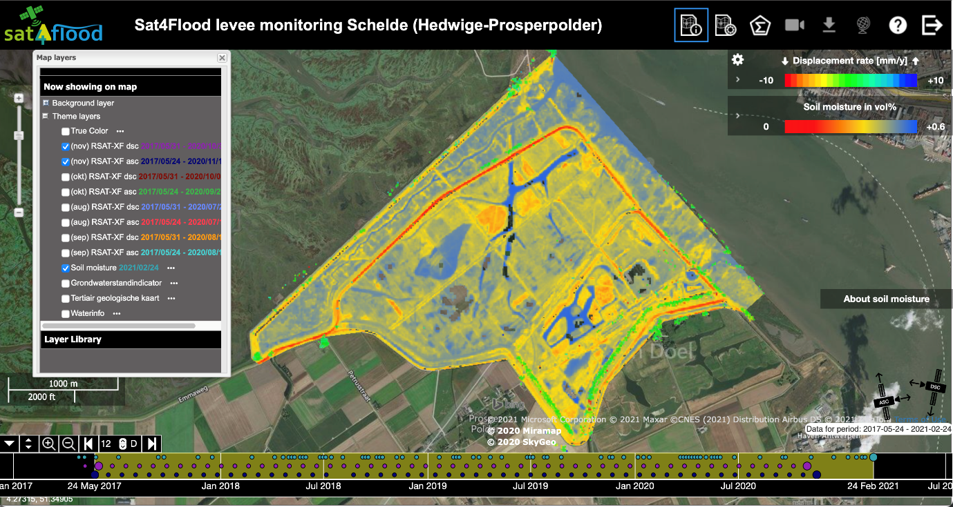
Sat4Flood provides organisations responsible for water safety with a cost effective tool to better understand and manage levee failure risks globally. Dutch activity partners Miramap, SkyGeo and 52impact developed the Sat4Flood monitoring service by combining satellite high-resolution soil moisture data with Interferometric SAR deformation data and other Earth observation data sources.

Since completing the InCubed activity, the Sat4Flood activity partners have started engaging with potential customers and rolling out the product commercially, beginning with water authorities and international engineering companies. As a result Sat4Flood is expected to soon join the ranks of former InCubed activities that are generating revenue.

Sat4Flood Project Manager Yvette Pluijmers from Miramap said: ‘’By combining our companies’ extensive experience in monitoring levees, we have been able to develop state-of-the-art technologies that can identify and monitor levee failures. The consequences of levee failure are huge and so Sat4Flood provides users with a much-needed product to help prevent the devastating impacts of levee failures.’’

Sea level rise, extreme weather such as hurricanes, storms and drought events around the world continue to cause levee failures. This can lead to critical flood defence failures resulting in tragic losses of life and the devastation of large areas. Sat4Flood service helps water safety organisations to prevent such failures by providing continuous and reliable monitoring of levees. The Sat4Flood service web portal provides information in a user-friendly way and potential levee hazard alerts are pushed to service users in order to proactively mitigate the risk.

ESA’s InCubed programme supported the development, validation and commercial viability of Sat4Flood. This included identifying key target customers, gathering their feedbacks on levee failures identification and visualisation to validate the product, up to engaging with three potential customers in a proof of concept validation. The proof of concept was a great success, the engaged customers received three months of fully operational service, to which they provided very useful feedback to further fine-tune the product.

Amanda Regan, Head of the Φ-lab Invest Office and InCubed Programme Manager, said: ‘’Sat4Flood provides water safety organisations with an invaluable product to monitor levee failures. The InCubed team have enjoyed working with Miramap, SkyGeo and 52impact to develop Sat4Flood and we wish them all the best in their commercial roll-out.’’

The Sat4Flood InCubed activity commenced in September 2019 and was successfully concluded during the final review in March 2021. A major finding of the activity was a clear confirmation of the benefits that satellite based systems like Sat4Flood can provide to users with customisable levee monitoring information.

To know more: Sat4Flood InCubed activity, Sat4Flood website, Sat4Flood video pitch

HubCAP kicked-off as a new InCubed activity

HubCAP is a newly launched product developed by the Irish Icon Group with the support of ESA InCubed programme. This Open Source “Hands-Free Monitoring” platform for integration with existing workflows will answer the emerging needs from ELMS/CAP (environmental land management system/common agriculture policy), which represent a deep interest for the Icon Group.

HubCAP will be a highly flexible Application Platform for the agriculture and environmental sectors, based on Copernicus data and the SEN4CAP (Sentinels for Common Agriculture Policy) toolkit. It is developed by the Icon Group, a European leader in Earth imaging services and Ireland’s largest processor of imagery data.

The objective of this newly developed product is to align with a new paradigm in Land Cover and Use Determination using satellite imagery that has been enabled by the move from an artisanal process to an automated workflow-based provision of information. This will free up trained and capable technicians to provide analysis and information, rather than just simple image-based products, making the end user experience easier and more tailor-made.

The HubCAP service is conceived as three modules, each with a different starting point:

  1. IACS Module (integrated administration and control system)  – this will be the Paying Agency existing interface for CAP users, which they will customise to obtain HubCAP information
  2. EO Module – based upon results of other activities (SEN4CAP, DIAS (Data and Information Access Services))
  3. Bureau Module – based on a validated user concept and other activities (IACS)

The system is simple – because it includes a comprehensive API (Application Programming Interface) for monitoring via direct integration with existing administration systems, wide, verified, fully supported and very customer focused. It is wide thanks to an advanced dashboard for conducting bespoke ad-hoc local analyses, and it is verified since it offers and supports integrated ‘geo-photos’ and other forms of verification, where required.

Also, each classification ‘transaction’ is fully recorded and certified, showing the algorithm version and image sets used.

Elaine Doyle, Icon Group Product Manager said: “HubCAP is a robust and simple platform through which Government Agencies (especially CAP, non-CAP Paying Agencies and Environmental Agencies), and commercial users will be able to access the benefits of Sentinel data in a fully supported, legally recorded and compliant manner. We are very happy to count on ESA InCubed programme support to develop and commercialise it”.

Patrick Griffith, ESA Technical Officer, added: “The market of EO based CAP monitoring service capabilities is now really taking up pace. HubCAP comes with some innovative concepts and will lead to the enrichment and diversification of this key market for EO services.”

To know more: HubCAP Activity page, Icon Group, ESA InCubed programme