
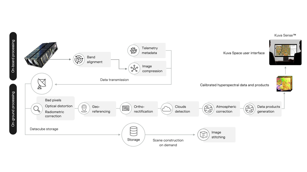
 Platform
  Payload
  Ground Stations & Mission Management
  Data Processing & Visualisation
  Data Analytics, Insights & Applications
 Climate change and geopolitical tensions are challenging our food security, environment, and national safety. The Hyperfield satellite constellation, combined with AI-based analytics, provides global, continuously updating, and actionable near real-time insights and alerts for timely action. Building a resilient society will be possible with gapless monitoring and automated processing of data in orbit and on ground.
Hyperfield helps food producers, businesses, and governments obtain timely information to make effective decisions towards safety and security, sustainable agriculture, and mitigation of climate change risks.
The service is global and targets primarily agriculture, aquaculture, blue carbon, crop insurance, defense, and security sectors.
Hyperfield combines a constellation of hyperspectral small satellites, ground segment and advanced AI/ML-based analytics to provide actionable insights to customers and end users.
The first-generation satellite for the constellation is developed jointly in this project by Kuva Space and the VTT Technical Research Centre of Finland. The 6U CubeSat carries a novel in-orbit tunable high-resolution hyperspectral imager covering visible to near-infrared wavelengths. Future satellite generations will cover short-wave infrared wavelengths by including additional imaging channels.
The mission operations are performed from Kuva Space’s mission control and ground station in Espoo, Finland, and through a third-party ground station network provider. The downlinked hyperspectral data is processed on ground to validate its usability to the selected customer and end-user applications. Advanced AI/ML-based hyperspectral data processing and analytics are developed concurrently with the project. The eventual satellite constellation will be launched after the validation mission and consists of tens of small satellites providing up to daily revisits to selected areas of interest.
Current hyperspectral offerings are delivering data based on tasking, where data processing is done manually. Kuva Space’s solutions aim to provide hyperspectral-based information-as-a-service at an affordable annual licensing fee. The company aims to make hyperspectral imaging data and insights more accessible by automating the data-to-insights processing with AI.
Two Gen 1 satellites have been launched successfully and are operational. The data from these satellites is used to run customer pilots globally and to develop and train Kuva Space’s AI models. Work is underway to launch two Gen 2 satellites in 2026, bringing in-orbit processing capabilities.


 email
email  Facebook
  Twitter
  Linkedin
  Whatsapp
  Copy link