Objectives of the Product
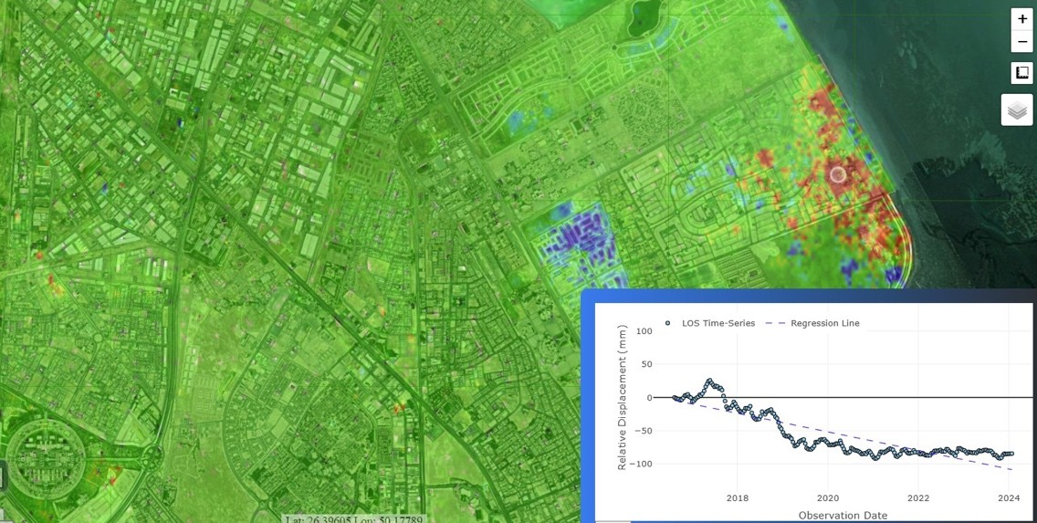
Monitoring ground movement and infrastructure stability is essential for public safety, but traditional methods are expensive, slow, and risky, especially in remote or difficult-to-access areas. CORE, developed by GVL, addresses this challenge with a smart and scalable solution that combines satellite radar (InSAR) and high-resolution optical imagery.
By integrating these technologies with artificial intelligence and machine learning, CORE delivers accurate, automated, and continuous monitoring of land and infrastructure. It provides early warnings of ground shifts or settlement, helping engineers, planners, and environmental managers act before issues escalate.
Unlike many systems that rely on a single data source, CORE combines multiple streams to offer a clearer and more comprehensive view of conditions across urban, rural, and natural landscapes. Its use of cost-effective off-the-shelf components and open-source tools also makes it more affordable and easier to deploy.
With CORE, users can remotely monitor large areas, reduce the need for site visits, improve safety, and make more informed decisions that support both infrastructure resilience and environmental sustainability.
Customers and their Needs
CORE is designed for infrastructure owners, public authorities, environmental agencies, and engineering consultancies that need accurate, reliable ground motion data to ensure safety, maintain assets, and meet regulatory requirements. These customers often manage large, complex, or remote sites such as railways, bridges, skyscrapers, peatlands, and floodplains.
Challenges include high costs, logistical complexity, and safety risks associated with traditional ground-based surveys. In many cases, manual monitoring is not feasible due to difficult terrain, vegetation cover, or restricted access. As a result, they lack continuous, real-time insights into ground stability, increasing the risk of delayed responses to potentially hazardous shifts.
CORE addresses these needs by providing a cost-effective and scalable monitoring solution that delivers continuous, automated, and accurate ground motion data across large areas. Customers can access processed insights via a user-friendly platform without requiring specialised expertise in remote sensing or data analysis.
Through the integration of AI, CORE also supports early warning systems and predictive maintenance planning. By reducing the need for on-site visits and improving access to high-quality geospatial data, CORE helps users manage risk more effectively, prioritise interventions, and improve long-term resilience of both infrastructure and the environment.
Targeted customer/users countries
CORE is targeted at customers and users across Europe, with a primary focus on the United Kingdom.
Product description
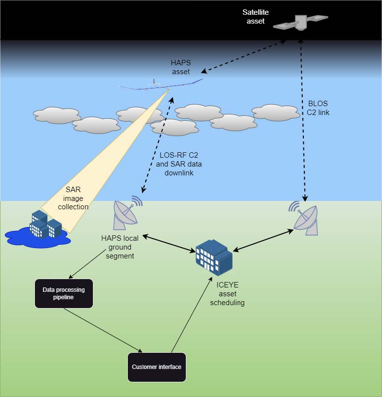
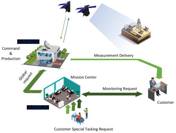
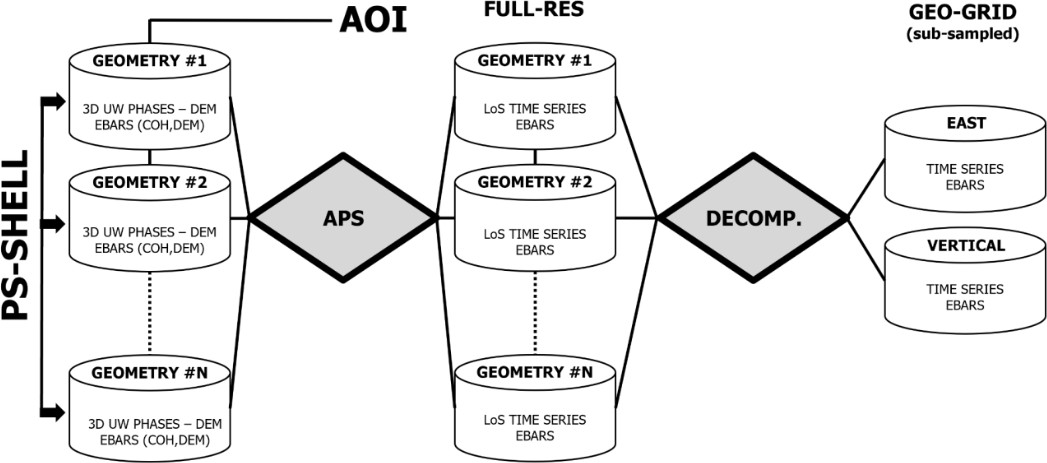
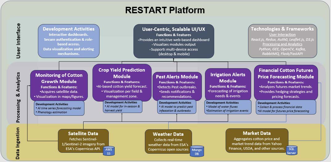
CORE is a modular, AI-powered ground motion monitoring system that integrates satellite radar (InSAR), GNSS-equipped corner reflectors, and optical imagery. It is designed to deliver continuous, accurate, and automated monitoring of ground and structural movement across diverse terrains, including urban areas, infrastructure corridors, and natural environments.
The system’s core building blocks include:
- Sensing Layer – AT-InSAR and PSInSAR data and optical satellite imagery
- Data Processing Layer – Open-source software and GVL’s AI/ML engine for data fusion, anomaly detection, and predictive analysis
- Visualisation and User Interface – A web-based platform that displays results through dashboards, maps, and alerts, enabling intuitive access for both technical and non-technical users
Innovation lies in the fusion of multiple sensing modalities with machine learning to improve data reliability, automate processing, and enhance early warning capabilities. Unlike conventional systems that rely on a single method, CORE adapts to varied monitoring environments with greater accuracy and efficiency. Users interact with CORE via a cloud-based portal, where they can access historical trends, real-time updates, and custom alerts to support decision-making, compliance, and risk management.
Added Value
CORE provides a significant improvement over traditional ground motion monitoring methods by combining multiple sensing technologies including InSAR and optical data into one integrated solution powered by artificial intelligence and machine learning.
Most existing systems rely on a single data source, such as PSInSAR, and often require dense infrastructure or frequent field visits. The project stands out by offering reliable monitoring across a wide range of environments including rural, vegetated, and remote areas where conventional methods are less effective or too costly. The use of Al-Terrain InSAR and open-source processing tools allows for higher quality results at a lower cost, making the solution more scalable and accessible.
The platform delivers continuous and automated insights, providing users with timely alerts and predictive analytics to support proactive management and risk mitigation. It is also designed with a user-friendly interface that does not require specialist expertise, enabling broader adoption. Compared to other systems that may be limited in scope, expensive to deploy, or slow to respond, CORE offers better coverage, increased reliability, and faster access to decision-ready data. This results in safer, smarter, and more cost-effective monitoring for infrastructure and environmental applications.
Current Status
In April 2026, the CORE project successfully achieved MS2 – Critical Design Review (CDR), confirming the maturity and scalability of the system architecture. The review validated the System Design and the Verification and Validation Plans, providing a clear path towards Milestone 3: the Factory Acceptance Test (FAT) in July 2026 and subsequent operational readiness.
Following MS2, the project is now well positioned to progress into system verification and testing, with reduced technical risk and a stable design baseline. Continued advancements have been made in InSAR processing, AI/ML-driven analytics, and advanced visualisation, strengthening CORE’s ability to deliver actionable insights for environmental and infrastructure monitoring.
In parallel, GVL has intensified stakeholder engagement and market-facing activities through dedicated workshops and pilot discussions. These interactions are directly shaping the service offering and supporting the development of commercial proposals, ensuring that CORE’s technical capabilities translate into customer value and long-term sustainability.