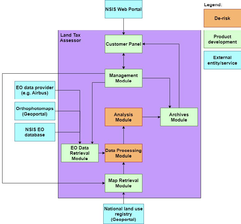
Objectives of the Product
The market’s insatiable demand for more data, at higher spatial and temporal resolutions, is driven by the need to gain deeper insight into the Earth’s environment and respond to the observed situations in a timely manner.
In response to this, the product developed under VISIONS offers substantial performance improvements over existing products in the SSTL portfolio, providing higher resolution data, as well as significantly greater data return, and is capable of rapid tasking and product delivery.
The problem to be addressed is providing the Earth Observation (EO) market with cost-effective sub-0.5 m resolution imagery, provided in a way that is timely, trusted, actionable and at a reasonable cost.
The multispectral payload developed in a previous activity enables customers to benefit from actionable data and insights at very high resolution to enhance their services and business operations in a wide range of vertical markets including agriculture, disaster and resource management, defence and security.
Customers and their Needs
For Commercial EO companies, customers need cost-optimised, high-performance imaging solutions in Low Earth Orbit (LEO) to maximise profitability of their business, shorten lead times to accelerate their time to market and revenue generation, and then to maximise the utilisation of their mission in a variety of markets and applications. Commercial customers also need an ability to scale operations rapidly in response to greater market demand, driving developments toward repeat builds, less bespoke solutions, and modularity in small satellite space systems.
Government customers (Civil and Defence) also express these commercial needs but with added pain points related to sovereignty and EO data independence, filling critical EO data gaps, capacity building and knowledge exchange, highly secure architectures with strict security and data traceability requirements, and finally value-for-money and ensuring the best use of public spending to benefit society and the economy as a whole.
Targeted customer/users countries
As a small satellite and payload manufacturing company, SSTL customers target satellite operators, across Commercial EO companies and Governments. Key target market areas include UK, Europe, Middle East and South-East Asia (EMESEA) .
Product description
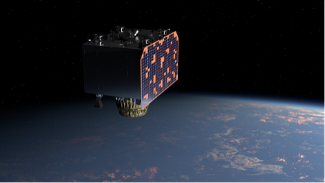
The VISIONS activity directly supports the delivery of SSTL’s Precision product; a 450kg, mini class satellite, capable of being compatible with affordable rideshare launchers, and capturing very-high resolution imagery from a 500-km orbit.
The Precision imager capitalises on half-pixel shifted pixels and processing in the PAN band to provide superior resolution and image quality (particularly benefiting from reduced aliasing). The half-pixel shifted pixels in the PAN band improve the spatial sampling from the native PAN GSD of 0.6m to 0.3m.
In addition, the Imager can also simultaneously capture four 1.2m-GSD multispectral channels from a choice of six available (Coastal blue, B, G, R, Red Edge & NIR). The product benefits from an upgraded downlink chain in X-Band capable of an Over the Air (OTA) data rate of 900Mbps per transmitter. The modular payload and downlink chain that sits on the spacecraft platform comprises upgraded avionics modules that are designed for constellation production to meet market demands.
The product is designed for a wide range of LEO spacecraft EO operators who can seamlessly integrate into their ground segment’s infrastructures and data service to their users and downstream value chain.
Added Value
Customers will gain combined added value over other small EO satellites on the market from the Precision product including:
- Increased information and intelligence value per square kilometre, through ‘best in class’ High EO Imaging Performance
- Reduced operational costs through increased downlink rate
- Reduced costs through compact design and ability to access affordable rideshare launch options
- Enhanced customer use and business cases through agility, tasking and data latency
- Reduced non-revenue generating data through access to on-board processing capabilities
- Rapid delivery, modular approach, and ready for production for constellations.
Current Status
The activity had its kick-off meeting on 23 October 2025.