

 Data Processing & Visualisation
  Data Analytics, Insights & Applications
 Offshore wind is an attractive energy alternative, however rigorous environmental legislation, a harsh and dynamic environment and more remote and widespread locations require thorough and meticulous planning and continuous operational monitoring frameworks of the wind sites and the dynamics of the surrounding water bodies.
However, the majority of the data and information needed to plan, construct and operate offshore wind farms is costly, time consuming and risky to collect, requiring rigorous field campaigns and expensive equipment. Collectively, such logistics is associated with high operational costs and hence limitations in terms of the frequency of inspection and total site coverage.
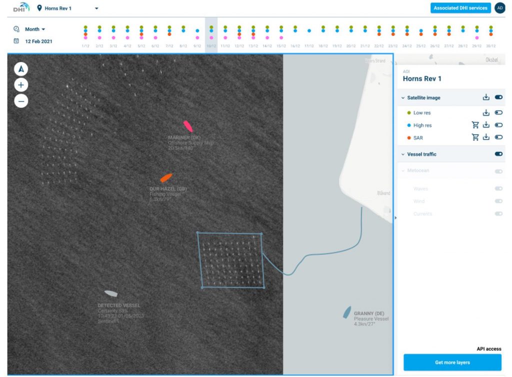
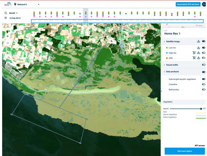
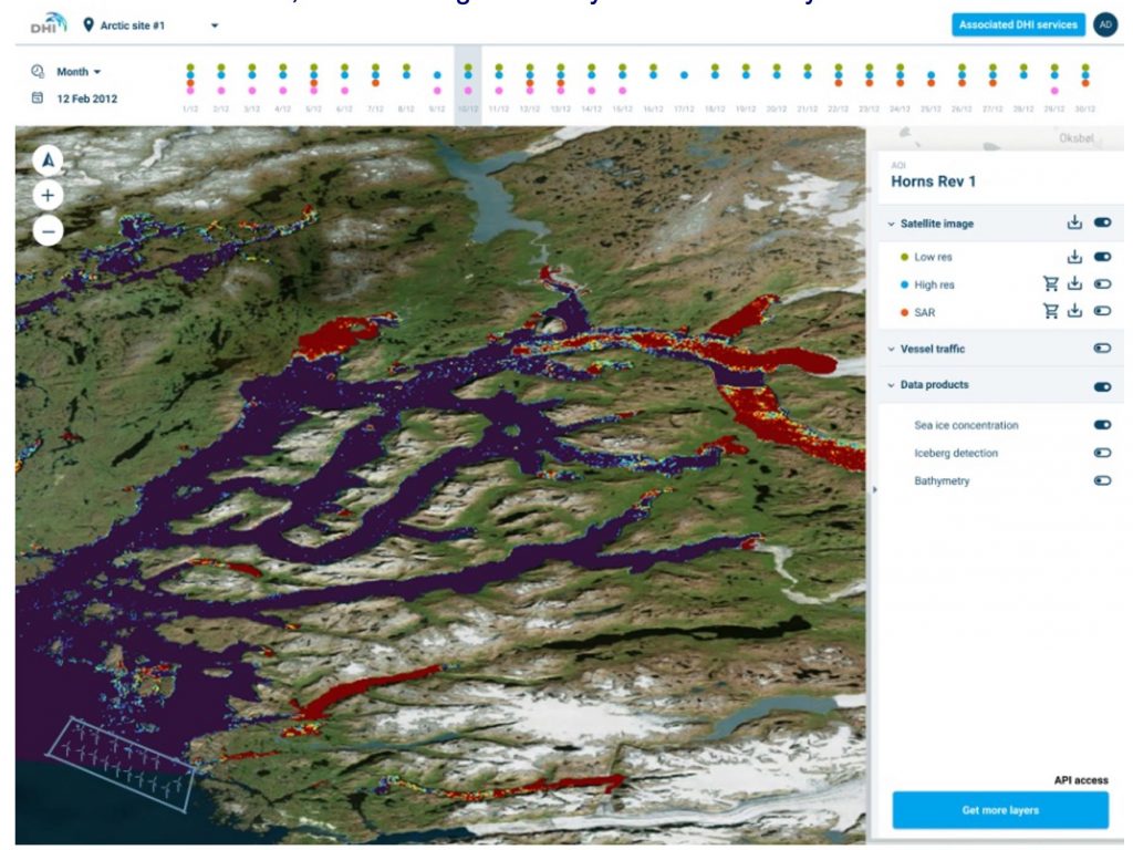
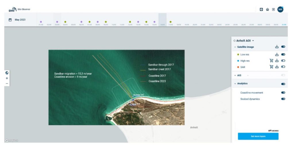
The high temporality and spatial resolution of modern EO satellite infrastructure combined with novel analytical frameworks and AI provides a cost-efficient and effective means to continuously track and monitor the status, change and dynamics at remote and widespread locations, such as offshore wind farms. Collectively, the effective utilization of these new satellite data sources provides a powerful, low cost and efficient tool to monitor seabed dynamics and movement, coastal dynamics, vessel traffic, turbine direction, sedimentation patterns, individual objects and several other parameters relevant for offshore wind operations and maintenance.
The Siteobserver project aims to assess existing data and information gaps in the offshore wind sector and identify the core user needs and requirements, as well as operational requirements, to make best use of such satellite-based surveillance frameworks. With a vantage point in these requirements, a prototype platform for operational application will be built in close dialogue with key stakeholders.
The overarching goal of the project’s user engagement was to ensure that a user base was built for the SiteObserver solution while it was being developed, and that the system infrastructure and tools were designed to meet the needs of this user base. To this end, a series of more specific objectives to the user engagement was formulated as follows:
To assess the user needs and requirements, a series of semi-structured interviews and informal meetings were held with key stakeholders, within the offshore wind industry, in the initial phase of the project. Some user needs and requirements have been further refined based on relevant experiences from stakeholders that DHI has gathered during 30 years of working with the offshore wind industry.
DHI engaged the potential end-users either directly or through the existing DHI network of business relationships and the initial outreach activities were conducted through a combination of email and teleconference calls.
Dialogue was established with several key stakeholders from the offshore wind industry and related sectors, and face-to-face (virtual) meetings were conducted with each of these stakeholders. Qualitative methods using semi-structured interviews were applied during these meetings to obtain a deeper understanding of each stakeholder, their associated work and activities, their use of geospatial data, perception about data gaps and needs and their view and knowledge about the potential of EO to address existing data needs. Additional information was collected more informally, in the margin of various events and associated meetings. All user meetings were conducted as open-ended interviews with the least amount of restriction to ensure unbiased insight to the user needs and potential market gaps. A series of questions were prepared before the meetings, but other questions were generated spontaneously based on the response of the participants. After the user needs have been identified, the process involved translating those needs into specific requirements across different segments of the offshore wind industry stakeholders.
Some of the key insights from the interviews with the stakeholders can be summarised as follows:
Tapping into a global market, target customers and users are global.
While user feedback indicated that continuous streams and easy access to raw near-real-time satellite data were not essential requirements, emphasis was put on the provision of high value EO derived information products on demand.
Four target products/services was identified based on the user requirements analysis:
Examples and mock-ups of such high value EO products and system integration within these four domains are exemplified by the examples below below.
Post incident intelligence can be related to natural disasters but also to vandalism, such as a buoy near a wind park that is intentionally destroyed or vandalized. Information about what vessel was nearby at the time of incident could be of interest.
Provision of information about marine and environmental habitat with different substrate types, with historical data to define a baseline before installation of the OWF infrastructure, and recent data to document either restoration of the habitat or to plan best the installation considering habitat health.
Sea ice mapping products are highly relevant for assessing operational risks, planning maintenance schedules, and ensuring the safety and accessibility of OWFs.
Coastal zone analysis products are relevant before constructing infrastructure but also during operation to monitor health of the marine ecosystem.
Currently, stakeholders in offshore wind are to a large extent relying on more site-based intelligence gathering (with helicopters/drones/ships/etc.) which is both costly and risky. Most stakeholders do not have up to date knowledge on relevant EO based assets or how to access these – therefore satellite data is to some extent underutilized. SiteObserver bridges a technology gap by providing easy access to relevant and context specific satellite data for the exact areas required by the key stakeholders. They get access to the latest satellite derived services and analytics relevant for their sites only and do not need to navigate through, or be familiar with, the vast quantities of different EO assets which are not relevant for their applications.
SiteObserver was completed in December 2023.

 email
email  Facebook
  Twitter
  Linkedin
  Whatsapp
  Copy link