

 Data Analytics, Insights & Applications
  Data Processing & Visualisation
 Satelligence Biomass is a report- and platform-based solution that helps companies understand their Scope 3 emissions and where the biggest issues occur in their supply chain.
The service shows changes in aboveground biomass for different supply chain levels (from farm to aggregators like mills and suppliers) to be able to make more targeted sourcing decisions. Satelligence Biomass is a new module/feature on our existing solution platform. The information can be used as part of the Science-Based Targets Initiative (SBTI) reporting or internally to make sourcing/investment decisions.
For SBTI reporting, additional information on Scope 1, 2 and other Scope 3 data needs to be integrated through partners or our clients, hence dissemination should be also flexible (API, exporting capabilities etc.). Before the project started, we already developed our carbon (aboveground biomass) algorithms for a number of regions and landscapes in pilot projects, with corporates like Mondelez International, Cargill and Rabobank, but more work was required to make this a scalable off-the-shelf solution.
With Satelligence Biomass we now service all multinationals that have net-zero commitments with reliable, science-based results.
The key customers segments targeted by our service are fast-moving consumer goods companies and large-sized traders active in soft commodity supply chains (e.g. palm oil, cocoa, soy).
Satelligence Biomass offers companies active in soft commodity supply chains a better understanding of their Scope 3 emissions due to land use change and agricultural expansion. This allows our customers to make better sourcing decisions and report progress towards compliance and reporting frameworks.
We have identified the following key pains:
And the following key gains:
Our target customers and users operate globally. Monitoring mainly happens in the (sub)tropics because of our commodity focus.
The functional blocks of the Carbon estimation model that need to be developed are:
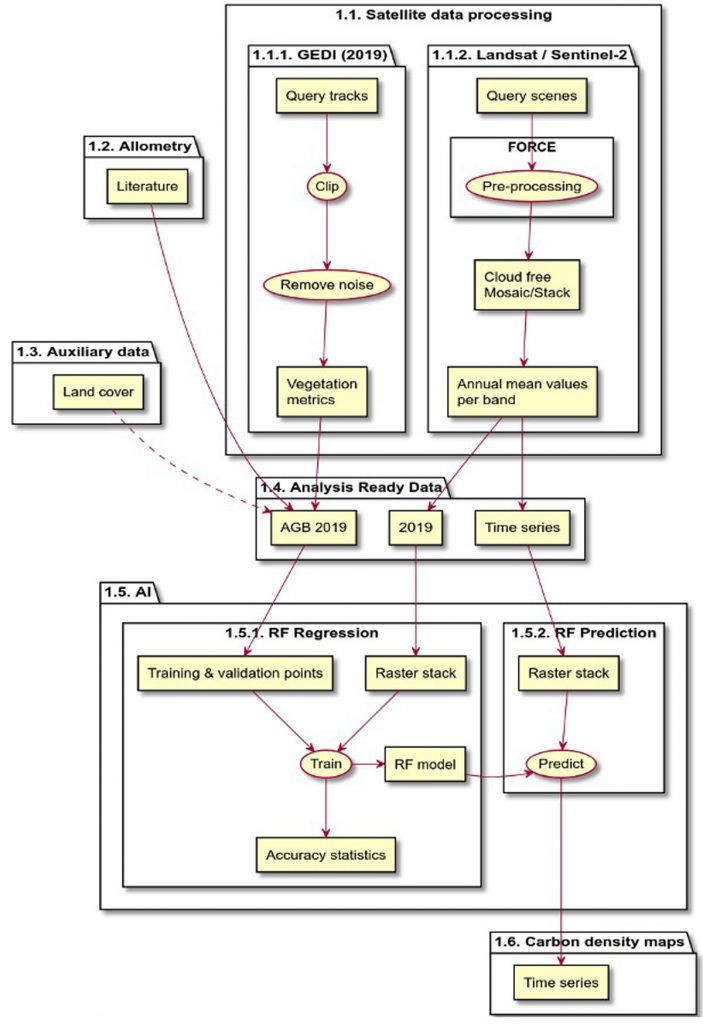
The model builds on results of the already operational satellite image distributed processing framework (DPROF).
The main (functional) modules are described in the table below. The modules can be separated into three main categories:
Innovation versus the market:
We can bring together those elements and have a first-of-its-kind solution on the market.
Satelligence Biomass had its kick-off on 6 July 2023.
The Satelligence team had several meetings with demonstration partners. Next, Satelligence also had a full day session with a consultancy to discuss a potential partnership.
We also started setting up an approach to sell Satelligence Biomass, including pricing options. These were tested throughout the project phase. The Final Review took place on 18 October 2024. By the project’s end, four customers signed up to the Satelligence Biomass service, totaling over € 250.000 in annual revenue.
The service is now ready to be commercialised at scale and we have a significant pipeline for the short- and mid-term periods.

 email
email  Facebook
  Twitter
  Linkedin
  Whatsapp
  Copy link