
 Platform
  Payload
  Ground Stations & Mission Management
  Data Processing & Visualisation
  Data Analytics, Insights & Applications
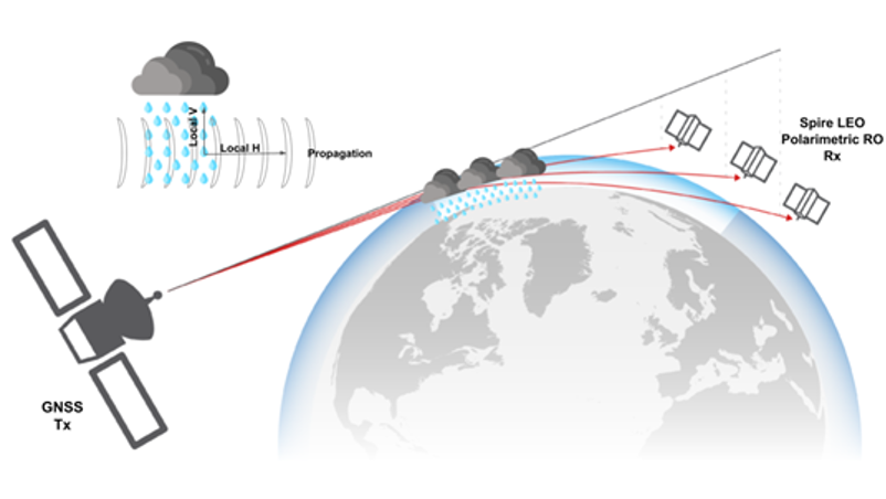
The understanding of extreme precipitation events is of critical interest for scientists as the frequency of those events is likely to increase and as they have a direct impact on many human activities (e.g., agriculture, logistics, accessibility to water, landslides or flood prevention, natural disasters) with devastating socio-economic consequences. Those events are controlled by moisture, but there is an absence of efficient measurements of such moisture profiles when precipitation occurs. By leveraging the capabilities of the CubeSat platform and growing experience on processing and analyzing GNSS-RO Data, Spire proposes to alleviate the heterogeneity and limitation of existing sensing solutions (infrared, radar, …) with an approach that could deliver valuable precipitation data, globally, with the potential to scale to a large constellation at a cost point that is substantially lower than today’s EO missions. This would potentially lead to a better understanding of events such as tropical cyclones, as well as better validation tools for cloud and precipitation models, improving weather forecasts.
There are 3 customer segments identified:
Interests have been raised in Europe as well as in American and UK based
institutions.
The main product consists of vertically resolved profiles of GNSS-PRO which are sensitive to the presence of precipitation and ice crystals as well as to temperature and moisture. The data are obtained from an in-orbit demonstrator payload aboard a CubeSat. These data produced by the GNSS-PRO sensor will be generated and formatted as per Earth observation standards.
The main components of the product will be profiles of calibrated polarimetric phase delay differences and derived features consistent with the vertical structures of precipitation, as well as the conventional output of GNSS radio occultations; combined together, they enable further capacities of detection such as the cloud top height or to potentially distinguish convective from stratiform precipitation. This would lead to a new data product to be fully embedded into Spire’s full range of weather data products.
| Modules | Functions/Features | Description/Design | Development Status | Critical Technologies |
| LEMUR Satellite Bus | Provides hosting of the PRO sensor in space | Use of Spire standard LEMUR bus | Fully developed and operational across the Spire fleet. No extensive adaptations required. | None |
| STRATOS Receiver | Processes GNSS RF PRO signals | GNSS receiver for several systems: GPS, Galileo, Glonass and QZSS | Modification. The STRATOS RO system is fully developed and has flight heritage. An adaptation of the receiver software has been performed to correctly combine two polarimetric ports. | RF multiband Multiservice Compressor |
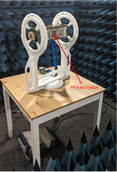
| PRO Antenna | Collects GNSS RF PRO signals, separated in H/V polarizations | An antenna consisting of an H/V polarimetric phased array of three microstrip square patches. Sensitive to horizontal and vertical polarizations (defined as azimuth and elevation directions from the antenna point of view, respectively) | New. Designed, manufactured, tested, launched, and commissioned. | Microstrip technology of phased arrays |
| PRO DATA PROCESSING SYSTEM | Ingests raw PRO data and produces a) Standard calibrated RO atmospheric profiles; and b) vertical profiles of polarimetric differential phase that exhibit a robust relationship with path-integrated precipitation and/or frozen hydrometeors. | Code responsible for calculating the polarimetric differential phase, for its calibration and interpretation in a vertical profile of heights. Quality check and outlier identification to reject invalid profiles. | New/Modification. Partially reused code from RO standard excess phase processing and partially new code to process the polarimetric differential phase part | RO inversion of refractivity. Calibration of the PRO antenna H and V phase patterns and cross-polarization effects. |
")
Spire sees GNSS-PRO as an incipient and innovative approach to the observation and measurement of rainfall under all weather and day/night conditions, and in accordance with an overarching vision to utilize GNSS signals of opportunity to generate valuable weather products with an already proven ability to deliver in this domain. The first and only space mission to carry a GNSS-PRO payload is the Radio Occultation and Heavy Precipitation (ROHP) experiment aboard PAZ, a Spanish Earth observation and reconnaissance satellite launched on 22 February 2018. Spire will innovate beyond ROHP in the following key aspects:
The activity concluded successfully following the final review on 17-October-2023.
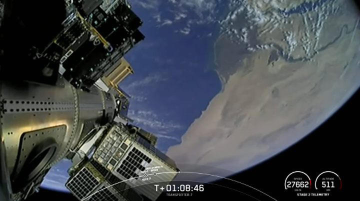
Following the successful design and manufacturing of the PRO payload, Spire has extended its trial to include two additional satellites, FM167 and FM170, alongside FM166.
These satellites were successfully launched and commissioned on 3-January-2023 and 3-February-2023, respectively. Since then, operational data flow has commenced, with approximately 2000 PRO profiles collected daily from all three FMs, achieving a latency of only a few hours.
Noteworthy findings from the validation campaign include the demonstration of comparable quality between RO retrievals based on dual-polarizations measurements and those from RHCP measurements, making them suitable for assimilation into Numerical Weather Prediction models.
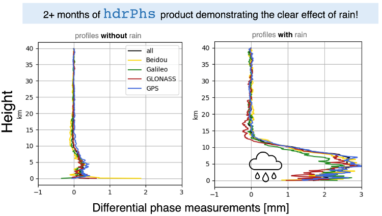
Additionally, differential phase profiles (H-V) have shown consistent positive shifts of 2-3 mm during rain events compared to no-rain events.
Moreover, on-orbit calibration of antenna patterns has yielded results consistent with ground-based calibrations, with minimal phase shift patterns (<0.5 mm), eliminating the need for further antenna calibration for the current validation scope.
The correlation between mean phase shift values (indicative of hydrometeors presence) and rain events, as determined by the IMERG product, has been established, with a notable hit rate of 74% for rain events and 90% for no-rain events based on 10,000 profiles.
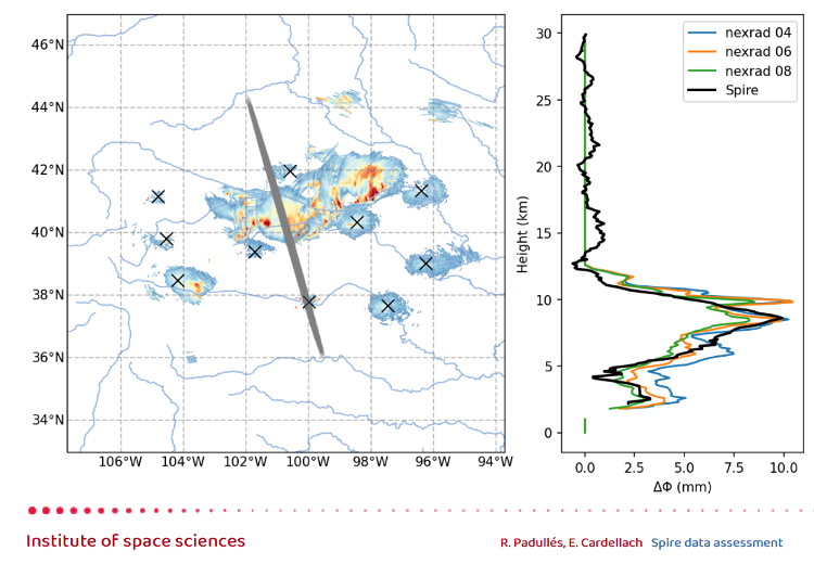
Validation results have been corroborated by external collaborators from CSIC/IEEC, including comparisons against additional sensors such as ground-based radars and case studies over hurricanes, further enhancing the credibility and applicability of the findings.

 email
email  Facebook
  Twitter
  Linkedin
  Whatsapp
  Copy link