

 Ground Networks & Data Distributions
  Data Analytics, Insights & Applications
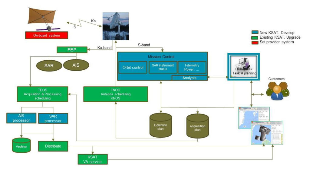
 The MicroSAR ground segment builds on the existing ground segment infrastructure at KSAT. This InCubed activity supports the development of new and innovative functionalities for real-time data take tasking using an upgraded KSAT Order Desk, communication between the ordering and the available satellite resources (“Mission Control”), access to the downlinked payload data from the SAR and AIS sensors, as well as a real-time SAR processor to feed the data and feed into the vessel detection and identification service chain.
The ground segment enables processing of downlinked data while the satellite downlink is ongoing. This includes direct stream of data, but optionally also to allow generation of traditional Level0 and Level1 products. The direct stream of data significantly decreases the time from the moment the downlink is done until a ship detection service is available for the end user. In order to support the direct streaming, new innovations have to be done both within the core SAR processing algorithms and its system design. The core SAR algorithms is designed to support the innovative new instrument behaviour that enables the high resolution and area coverage of the SAR instrument. This capacity, together with the global KSAT ground station network, provides the users with global information about vessels at sea in less than 30 minutes.
There is a strongly increasing global need for updated, reliable information about vessels, for applications including general safety at sea, but in particular for national sovereignty, illegal fishing, illegal immigration, smuggling etc. In this context, (near)real-time access to information about the vessels means much less than one hour after acquisition of data. The customers conclude subscription agreements for a systematic, long-term monitoring of their AOI’s. In addition, there is an increasing demand for short term/real-time tasking which has not been possible yet. The demand for information extends from getting the position, time and (AIS) identity of the vessels, onto details about the vessel category, size, speed and heading.
The output vessel detection information generated in the MicroSAR ground segment is addressing primarily main stakeholders in the institutional sector, e.g. including Norwegian government, other national governments and institutional users. These users have global interests, with an increasing focus on information about small(er) vessels and where the areas of interest may change very fast. Contract opportunities arise from both open tenders and confidential bi-lateral agreements with the provider. The success of the activity is measured in terms of vessel information sales to global customers. The activities following the development is self-standing and the success depends upon the result of sales and marketing in terms of number of customers.
The customer base is fully global.
The baseline for the development of the MicroSAR ground segment is the existing KSAT ground segment, to be upgraded with the facilities and functionalities needed to handle the increased data downlink rates, data volume and customer requirements for access to the information. The rationale for the proposed architecture are:
Delayed tasking and provision of data for information extraction is an important limitation on existing SAR missions. The Mission Control unit is the interface between the satellite and the order desk and provides information about what data takes might be possible. KSAT has an ordering tool developed by a European company that is further developed to include the new direct tasking opportunity. This develops both the actual providers competence on advanced mission planning, as well as KSAT operational competence.
The SAR processor is developed as a dedicated processor tailored for just this sensor and producing just the required output to feed into the vessel detection algorithms. The ground segment operates a SAR processor which can process the data (almost) as fast as the data is downlinked.
The ground station components all communicate using the EOSPS standard (the Earth observation extension OGC 10-135 to the OCG Sensor Planning Service OGC 09-000). A similar standard (OCG 06-141r6) is already used in some of the existing KSAT ground station components, so competence related to the practical use of such standards is already available in the activity. Available interfaces which do not use EOSPS (yet) communicate via (rather simple) proxies. This standard is used for planning and communicating about the sensing, down-linking and processing, not for defining formats used in the actual downlink, storage and processing.
Today KSAT’s access to EO data for the services utilization depends upon agreements with commercial satellite owners/operators. KSAT aims at being an independent service provider which is not biased to use own mission data. The MicroSAR mission fits into this operational strategy. KSAT has the data rights and performs the operations. This improves the competitive position even further as an independent global provider of (near)real-time multimission maritime information services.
The competitive operational edge with the mission and ground segment is the sensor dedication for vessels only and the fast data request take turn-around and information delivery time. The new system enables a strongly improved service offering the following features over the current service:


 email
email  Facebook
  Twitter
  Linkedin
  Whatsapp
  Copy link