

 Data Analytics, Insights & Applications
 Wildfires are a critical challenge exacerbated by climate change and combustible biomass accumulation. The objective of FireTwin is to provide predictive wildfire-risk maps to enable forest managers and public authorities to implement preventive actions that mitigate the risk of extreme events. FireTwin addresses the lack of reliable fuel load and moisture information by fusing satellite imagery (Sentinel-2) with climate data to estimate Live Fuel Moisture Content (LFMC). The product delivers high-resolution risk maps and short-term forecasts through interoperable API data services or a ready-to-use hosted platform, supporting operational decision-making and climate resilience.
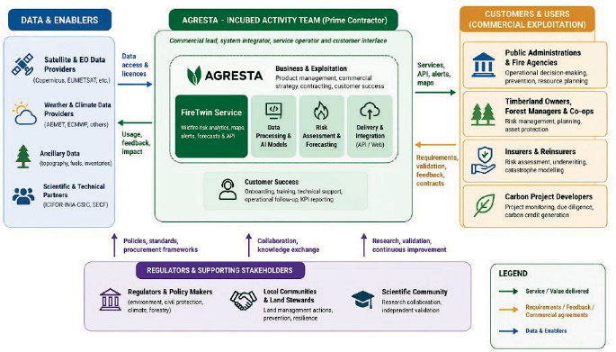
The main customer segments encompass public administration (wildfire prevention and civil protection services), timberland owners, forest managers, insurers/reinsurers, and carbon project developers.
These customers face the challenge of obtaining localised, accurate, and continuous fire-risk intelligence for decision-making. Their needs include better preparedness during critical risk windows, auditable operational alerts and reducing the high technical cost of integrating new tools. FireTwin addresses these points by providing risk intelligence and short-term forecasts (24 to 72 hours) to plan patrols, assess eligibility and pre-position emergency resources. Furthermore, its dual delivery model (API or web) reduces technological friction during user onboarding.
Spain (beachhead market), the rest of the Iberian Peninsula and Mediterranean Europe countries.
FireTwin is a modular cloud-native system (PaaS) that integrates Earth observation (EO) data, meteorological networks (AEMET, ECMWF) and in-situ data with artificial intelligence (AI) modules to generate Live Fuel Moisture Content (LFMC) modelling.
In terms of its architecture, the system features automated ingestion modules, an AI engine that calibrates wildfire risk (nowcasts and 24 to 72-hour forecasts) and European cloud infrastructure, guaranteeing data sovereignty.
To facilitate customer interaction, the service relies on a dual delivery architecture: an API gateway and interoperable OGC geospatial services for direct integration into control centres or third-party systems and an intuitive web platform providing interactive maps, dashboards and alert configurations for non-technical users.
Compared to competitors and existing tools (such as Copernicus EFFIS/GEFF or Technosylva), the added value of FireTwin lies in its hyper-local focus on current conditions (operational nowcast). It offers high spatial detail and low data-to-map latency (≤6 hours processing time), which is critical for operational responses.
Unlike competitors that require complex IT integrations or cover overly generic areas, FireTwin stands out for its lightweight integration via interoperable APIs and fully explainable risk outputs and alerts. All of this is complemented by localised support and auditable historicity, an essential requirement for governance reporting and insurance or carbon market audits.
The activity advances through two interconnected cycles: a de-risking cycle focused on validating and confirming the feasibility of the short-term forecast capability (meteorological integration and LFMC modeling), and a product development cycleaimed at building and scaling the comprehensive operational service to a TRL 7 level. The system builds on mature technological heritage from over a decade of prior research and development by Agresta in satellite forest monitoring (including projects like FIREPOCTEP+, VIS4FIRE, and CILIFO), moving from fragmented tools to a centralised, cloud-native architecture.

 email
email  Facebook
  Twitter
  Linkedin
  Whatsapp
  Copy link