

 Data Analytics, Insights & Applications
  Data Processing & Visualisation
 Biodiversity plays a vital role in supporting food security, clean water, medicine, and resilience to climate change. The UK and other governments are committed to reducing the negative impacts of development on biodiversity, while also enhancing habitats to support its recovery.
In the UK, all investments are required to deliver at least a 10% net gain in biodiversity. As a result, developers must demonstrate that they have assessed the biodiversity value of existing or improved habitats using Standardised Biodiversity Units (SBUs). However, calculating these impacts—especially for large-scale projects like new water resource schemes—can be time-consuming and costly.
Earth observation (EO) data offers a way to streamline parts of this process by automating biodiversity impact assessments across landscapes. EO4Biodiversity supports the creation of a tool that enables public bodies, businesses, and infrastructure developers to carry out automated evaluations of how different development options affect biodiversity. The tool identifies habitat types based on UK government classification standards and calculates biodiversity values using SBUs, helping to simplify and accelerate the assessment process.
The legislation on Biodiversity Net Gain (BNG) applies to all new developments—including energy, transport, water, and housing—making the EO4Biodiversity tool relevant to a wide range of potential users.
Initial buy-in and a strong commitment to co-development and early adoption have already been secured with Water Resources South East (WRSE), one of the five regional water resources groups. WRSE brings together six water companies and a broad coalition of stakeholders, including the Environment Agency, Natural England, Ofwat, local planning authorities, and environmental organisations.
In its most recent regional plan, WRSE assessed over 4,000 scheme options. Each option may involve multiple assets spread across large areas, with significant construction impacts. Manually calculating SBUs for each option is estimated to cost around €1.6 million—and this process must be repeated every five years.
An automated approach is therefore essential. EO4Biodiversity addresses this need by enabling efficient, repeatable biodiversity assessments at scale, helping organisations meet regulatory requirements while saving time and resources.
EO4Biodiversity supports strategic biodiversity net gain (BNG) requirements set by the UK government, as well as similar policies under the EU’s Nature Restoration Law. The project addresses both societal and productivity impacts:
By aligning with these legislative frameworks, EO4Biodiversity ensures relevance and value for a broad range of stakeholders working to meet biodiversity goals efficiently and effectively.
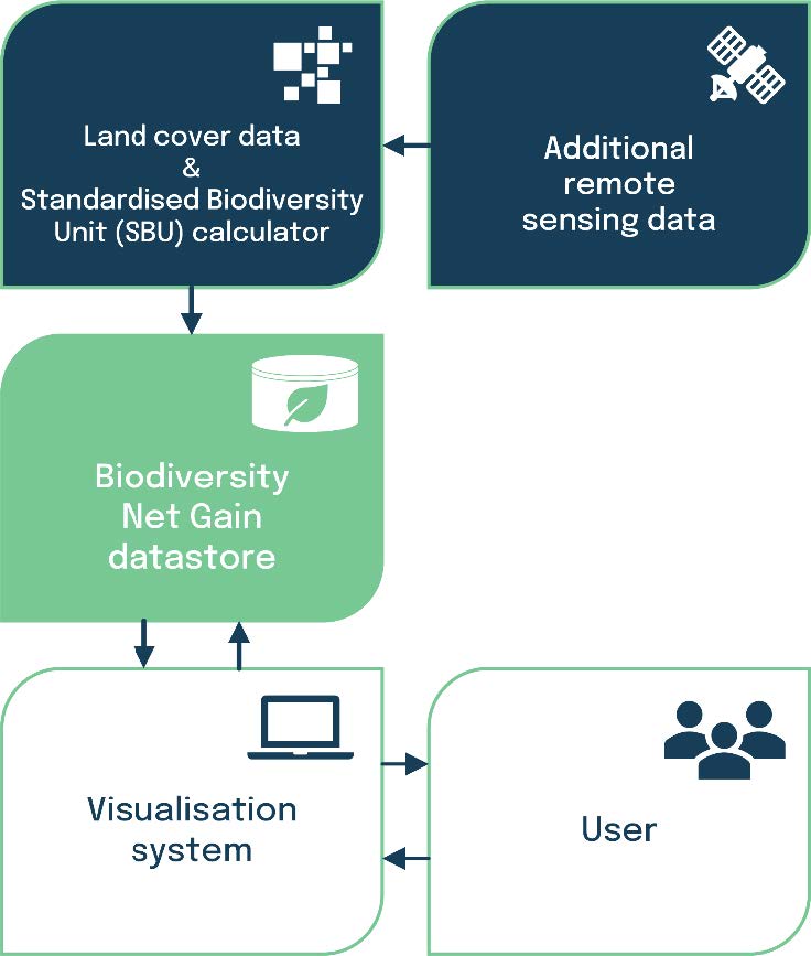
EO4Biodiversity automates the identification of habitat types using formal definitions from UK government biodiversity evaluation processes. It also streamlines the calculation of SBUs, reducing the time and cost associated with manual assessments.
The service processes freely available land cover datasets and integrates optimisation tools to support the review of development options. Earth observation (EO) data is enhanced with existing datasets from public entities and refined through machine learning techniques.
These elements—EO data, ground truth information, and machine learning—are combined in a web-based application called EO4Biodiversity. This tool is designed for use by a wide range of public sector organisations and commercial developers.
Assessing the biodiversity impacts of new infrastructure projects, such as water resources or energy schemes, is now a statutory requirement. Currently, these assessments are carried out without the benefit of EO data. EO4Biodiversity introduces a new approach by post-processing publicly available EO land cover datasets to meet the specific needs of biodiversity impact analysis and BNG compliance.
No other solutions currently available in the market offer the same level of functionality as EO4Biodiversity. The project was initiated in response to a direct request from Water Resources South East (WRSE), a consortium of six water companies, who sought a more efficient method for assessing biodiversity impacts using Earth Observation (EO) data.
WRSE currently relies on a series of manual steps that are both time-consuming and costly. By automating key parts of the process, EO4Biodiversity addresses a clear gap in the market, offering a scalable, data-driven solution that meets the growing demand for efficient biodiversity net gain assessments.
The activity covers the identification of requirements and the development of the system architecture for the EO4Biodiversity tool. This includes a detailed exploration of statutory requirements for biodiversity metric calculations, a review of existing tools and UK government guidance, and an assessment of current habitat-type databases to evaluate their suitability for integration.
These foundational tasks ensure that the tool is built on a robust understanding of regulatory needs and existing resources, setting the stage for a solution that is both compliant and practical for end users.


 email
email  Facebook
  Twitter
  Linkedin
  Whatsapp
  Copy link