
 Data Processing & Visualisation
  Data Analytics, Insights & Applications
 Re/insurance and risk modelling companies suffer a serious lack of high-quality per-building data. Nowadays, they build their analysis upon aggregated and statistical datasets, which are characterized by low quality, obsolescence, and coarse resolution.
Lack of high-quality property data implies poor risk estimation, which may translate into large, unexpected losses when a disaster happens. Moreover, uncertainties in risk estimation are frequently offset by increasing the policy premiums to final customers, and thus decreasing the insurers’ competitiveness in the market.
The effects of climate change contribute to exacerbating the problem, and statistics have indeed shown an increasing trend for losses at global scale. The number of events per year ramped up from 249 in 1980 to 820 in 2019. Since 1980, the total losses due to natural disasters have reached 5,200 US$ billion.
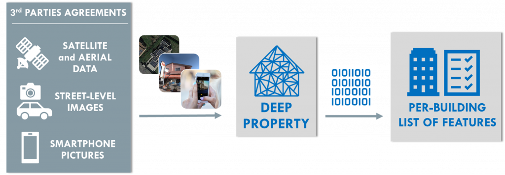
Deep Property is tackling this issue by providing detailed, on-demand, high-quality building data at the global scale. It applies proprietary AI-models to geospatial datasets, like satellite and street-level images.
A SaaS model is offered, leveraging an API-based infrastructure. It provides a fair pay-per-use scheme and, most importantly, a smooth integration into the customer’s environments. The entire service runs on the cloud.
The key customers segments targeted by our product are: Insurance, Reinsurance, and Risk modelling companies. All share a high-level need, namely high-quality building-scale property data, while using the purchased data for different applications.
Insurance companies need property data for three main applications: identification of a fair and competitive price, policy renewal, and claim management. Reinsurance companies need property data to better assess the risk for a large portfolio of buildings. Risk modelling companies use detailed data to improve the quality of their models, and thus increase the value in front of their customers.
Property data include several different pieces of information. Among these, there are: area, roof type, construction year, overhanging trees, greenness index, solar panels, presence of swimming pools, flood barrier, number of floors, material, occupancy, building type, first-floor elevation, basement, maintenance status, etc. The relative importance of each element changes in accordance with the addressed geographical region, e.g. in hurricane-prone areas, information about roof type is highly valuable.
The main stakeholders involved in the activity will validate the product considering both technical and business point of view. More specifically, a set of analysis will be done to assess the added value provided by Deep Property.
Deep Property can provide data about individual buildings anywhere, at a global scale. However, the main regions of interest for identified potential customers are European countries and the US.
Deep Property is a service able to derive property features by applying proprietary AI-based techniques over several geospatial datasets including satellite data, street-level images, smartphone pictures, etc.
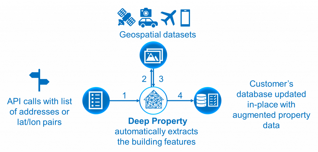
Deep Property is offered through a pay-per-use SaaS scheme. The data is requested through an API scheme, where final users submit latitude and longitude of the property location of interest (or its physical address), together with a list of desired features. Once the submitted data is received, Deep Property retrieves the relevant geospatial datasets, then it applies the AI-based models to extract the requested pieces of information, and finally delivers the analysis results to the final customers. It should be remarked that the API-based scheme automatically updates information in the customer’s database, thus making integration of DeepProperty much smoother.
This is key to the effectiveness of DeepProperty, because the system operates in a transparent manner, and the customer does not need to learn new platforms and operations. The guiding idea is to let our customers work as usual but with better data.
An overview of the processing workflow is available in the figure below:
In the end, a full cloud-based solution allows to scale up easily when dealing with large amounts of requests.
The lack of property data is a problem to which many companies worldwide try and offer a solution. Most of them, however, focus mainly on satellite images and drones as their sources of raw data.
Satellites provide a clear overview of the buildings from a nadiral observation point, and thus are indeed useful to retrieve some physical features of the buildings (e.g. footprint, roof-type, etc.). Yet, satellite images are insufficient to retrieve all risk-related features.
Drones provide a wide range of vantage points, but their coverage is extremely limited, and new, specific acquisitions are generally required for any new building mapping operation.
In our case, unlike our competitors, we use satellite images combined with street-level images. Whereas satellite images provide data on footprint, area and roof type, street level images cover several additional exposure-related characteristics. The combination of the two data sources guarantees a far more complete portfolio of data for our customers. Many data providers are acquiring street-level data for road sign mapping and self-driving car applications, thus guaranteeing good coverage in many urban areas as a by-product; such data can be re-used for our service.
The activity officially kicked off on June 30th, 2021, and it has been concluded on April 30th, 2023.
Through the utilization of proprietary AI models, the service has the capability to analyze geospatial data and provide more than 10 building features in nearly real-time. The service operates entirely on a cloud-based framework and manages requests through an API-based interface. Moreover, new features can be integrated easily using a plug-and-play approach.
The Deep Property service focuses on various markets where property data is valuable. These markets include insurance, real estate, energy, and ESG rating assessments.
are required.

 email
email  Facebook
  Twitter
  Linkedin
  Whatsapp
  Copy link