
 Data Analytics, Insights & Applications
 The main problem in the Earth observation (EO) market is that the technology used is too complex and requires specialised knowledge for most users to interpret satellite data and integrate it into their operations, hindering wider adoption.
The solution is the ENGINE project, an AI-powered agent integrated into the SpaceKnow Guardian® platform. Its objective is to democratise geospatial intelligence, initially focusing on urban development and construction monitoring.
ENGINE achieves this by:
This integration streamlines the entire analysis process, making powerful, scalable EO insights accessible to a much broader range of businesses and organisations.
The targeted primary customers for the activity are from the urban planning and construction monitoring segments. Other key segments include national security entities, NGOs, and the oil and gas industry. The long-term vision is to expand to virtually any organisation that can benefit from scalable satellite imagery analysis.
Customers face challenges due to the complexity of integrating Earth observation (EO) solutions and the need for specialised, technical expertise to interpret geospatial data. This creates a steep learning curve and limits adoption. Users interact with the product, ENGINE, an LLM-powered autonomous agent, by using natural language (written or spoken) to control the system and request analyses. This involvement allows them to autonomously monitor projects and receive actionable insights and contextual information without needing expertise in remote sensing.
Europe, US, KSA.
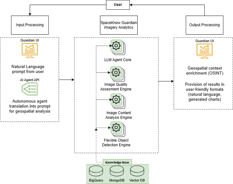
The product is ENGINE (SpaceKnow Guardian® Operator), an LLM-powered autonomous agent integrated into SpaceKnow’s cloud-based platform, SpaceKnow Guardian®.
Capabilities and Innovation:
ENGINE’s core capability is democratising geospatial intelligence. It transforms the analysis of satellite images (IMINT) by combining it with contextual data from open-source intelligence (OSINT). The innovation lies in the LLM-powered agent, which simplifies the entire geospatial analysis workflow, dramatically reducing the technical knowledge required from the user. It also employs proprietary algorithms to process challenging low-resolution SAR images.
User Interaction and System Outline:
The user interacts with the product using natural language (written or spoken inputs). The system processes the request and delivers results as automated responses in an LLM-processed format (written, spoken, or visual).
The proposed solution, ENGINE, brings added value and a competitive edge through several key innovations:
The activity kicked off it the beginning of Q4 2025. Currently, the first work packages are running, focused on State-of-the-Art Review, Foundation Model and Agency Framework exploration, and External Data Research. These work packages will be reviewed in the first milestone. The Requirements’ Review is planned for 11 December 2025.


 email
email  Facebook
  Twitter
  Linkedin
  Whatsapp
  Copy link