
 Data Analytics, Insights & Applications
 Navigation in the Arctic and Antarctic can be a hazardous undertaking in a harsh, remote and yet very fragile environment. Finding the safest route through ice-infested waters requires searching for, collating and understanding data from a variety of sources often scattered across the internet. These data are often in formats useful for scientific analysis but not easily usable for nautical staff; file sizes are also prohibitive for the low-bandwidth internet connections common in the polar regions.
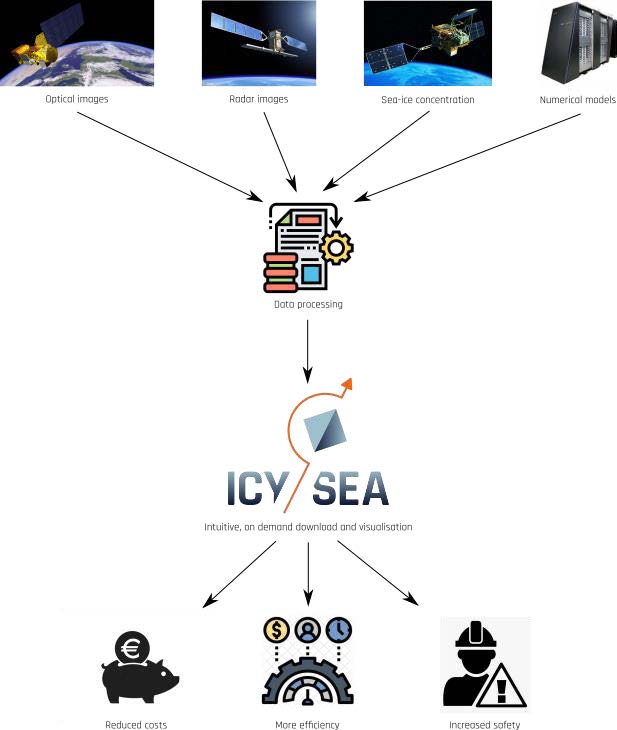
IcySea solves this big-data problem by bundling near-real-time scientific sea-ice data into an easy-to-use app in which the user can download and visualise sea-ice information applicable to their current situation on demand and optimised for low-bandwidth connections.
IcySea therefore turns data into useful, relevant and timely information.
ESA InCubed allows the broadening of the capabilities of IcySea to include more datasets and extend the coverage of current datasets, to add useful navigational features, and to incorporate products resulting from previous and ongoing research projects. These additional capabilities will help to make IcySea the essential sea-ice information platform on any ice-going vessel.
IcySea’s customers and users include any party navigating or operating in the polar regions. Such parties include expedition cruise operators, cargo shipping, fisheries, as well as research institutes and surveying companies. IcySea was developed in an open and collaborative manner: everyone in the value chain has an influence on the features provided by the app and any feedback received from end users flows back into the app as, for instance, feature enhancements or extensions.
Because sea-ice information is scattered across the internet and is often in a form difficult for lay people to understand, IcySea simplifies collection and display of relevant sea-ice information to make it useful for navigation in ice-infested waters. Customers thus save time and can focus better on their task of navigating in hazardous conditions.
By having up-to-date near-real-time information, crews can find faster, safer routes through the ice thus saving not only time, but large amounts of fuel and money. Also, better information reduces contact with the ice, thus decreasing hull erosion and reducing the need for costly repairs in the dry dock, as well as reducing insurance costs.
All countries involved in shipping in the Arctic and Antarctic.
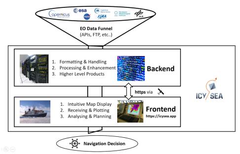
IcySea is a progressive web app designed specifically to support polar maritime activities with data from space. It bundles sea-ice information into an easy-to-use app in which users can download and visualise relevant sea-ice information on demand; all optimised for low-bandwidth internet connections.
IcySea’s main innovations include animated ice drift forecasts, automatic ice classification, automatic route optimisation, navigational-support features, and a highly automated backend data processing system.
The customer interacts with IcySea via an app installed on their device (such as a mobile phone or tablet) or via the IcySea web page on a desktop or laptop computer.
Basic structure of the IcySea service:
IcySea is already available and in use by customers in the field. In addition to the data sets present at the beginning of the activity (6km resolution sea-ice concentration data, high-resolution radar images and machine-learning-optimised ice-drift forecasts for the region surrounding Svalbard) we have integrated a 3km sea-ice concentration data product and have extended coverage of radar images to important parts of the Arctic and Antarctic. It is now possible to export ice drift forecast data in either GeoJSON, KML format or as .png files. A measurement tool for route planning is now available as well as Arctic-wide sea-ice drift forecast trajectory information. As of 2024, this InCubed activity is now completed.

 email
email  Facebook
  Twitter
  Linkedin
  Whatsapp
  Copy link