
 Data Processing & Visualisation
 By using satellite radar sensors (e.g., Sentinel-1, COSMO-SkyMed and COSMO Second Generation, TerraSAR-X), it is possible to obtain mm-accuracy displacement data from space, without having to install anything on the ground. InSAR technology has rapidly advanced to become a standard tool for measuring ground deformation phenomena.
Fast standard reports about trends and changes of the ground surface – also known as “bulletins” – showing movements ranging from mm to cm, are nowadays produced through a supervised process, after each new satellite acquisition.
Bulletins are currently sold to those customers who are committed to frequently monitoring fast changes occurring in the asset of interest. Target markets are the Mining sector, O&G, and Natural Hazards in the case of abrupt events (volcanic events, post-Earthquake).
According to the clients’ feedback, bulletins must have a dramatically faster delivery time, a clear description of the reliability of measurements, and a cost reduction in the view of scalability. Along with these, requirements about the User’s Experience (bulletins visualisation and browsing) are stressed.
The BulletInSAR activities aim to enhance the production of bulletins through a ML-based unsupervised process to match the market’s requirements of timeliness, reliability, scalability, and user-experience.
Deformation Fast Reports (Bulletins) are currently delivered to the market.
The Clients’ Community, made up of large international groups managing several assets worldwide, while appreciating the impact on their activities, provides feedback on critical factors that are limiting an effective day-by-day application to the monitoring of their assets. Customers’ needs touch the following critical points:
Production time and costs to be applicable to systematic use over several assets.
Worldwide
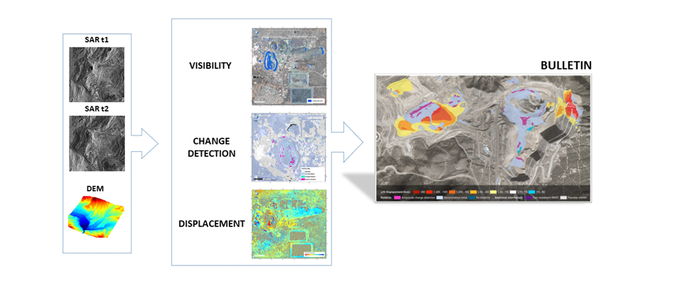
The Bulletin product currently consists of Fast Deformation Reports, derived from a pair of SAR acquisitions and semi-automatically delivered to the Client using the web-based tool TREmaps®.
Bulletin production starts from the following inputs:
and consists of a collection of three information layers:
Bulletins are already considered a valuable tool by our clients: their request is to extend this kind of project to a higher number of assets worldwide. To cope with this request, BulletInSAR improves the product in terms of:
After the demonstration phase, consisting of two pilot activities with two users
using C and X band data, both in Ascending and Descending passes, the BulletInSAR
project is now complete.
The demonstration phase has shown how the new ML-based designed product
matches the Users’ expectations, both in terms of informative content (reliability) and
in delivery aspects (timeliness, scalability, user experience).
The BulletInSAR product is part of the sales portfolio and is currently proposed to the
Mining Industry clients.
A CCN1 is ongoing with the aim of designing and testing a Van Atta array artificial
reflector.
The CCN3 activities aim at developing two new lines:

 email
email  Facebook
  Twitter
  Linkedin
  Whatsapp
  Copy link