
 Data Processing & Visualisation
  Data Analytics, Insights & Applications
 The Full DSS is an innovative tool providing highly valuable insights obtained from the correlation of several data sources to support AI processes that can provide suggestions and better communication for the farmers inside the value chain.
As a matter of fact, the product is an advanced Decision Support System (DSS) able to combine modelling and remote sensing historical information to diagnose hot spots of vegetative stress, highlighted by remote sensing, pests and disease detection models.
The ambition is to overcome the two main problems of agricultural DSS:
In fact, satellite data collected and elaborated by AgriTech platforms are usually able to identify general issues (such as areas with reduced vigor within each field) but cannot provide precise diagnosis of the seriousness of the vegetation vigor issues and information on its possible causes. On the other hand, traditional DSS can provide specific information on single issues, such as field water or nutrients needs, pest risks etc., which usually refers to the whole field, without differentiating between areas of the field. With the Full DSS, all information can be integrated, providing tempestive feedback on what is happening in the field, where it is happening and why, giving some agronomic advice.
AgriTrack Full DSS Stack can directly support a wide range of stakeholders with direct and indirect benefits. The targeted customers are:
Facing an ever-evolving environmental and economic landscape, farmers, consultants, and other actors in the agronomic sector increasingly require identifying critical areas within the field and plan new and immediate intervention action remotely and timely.
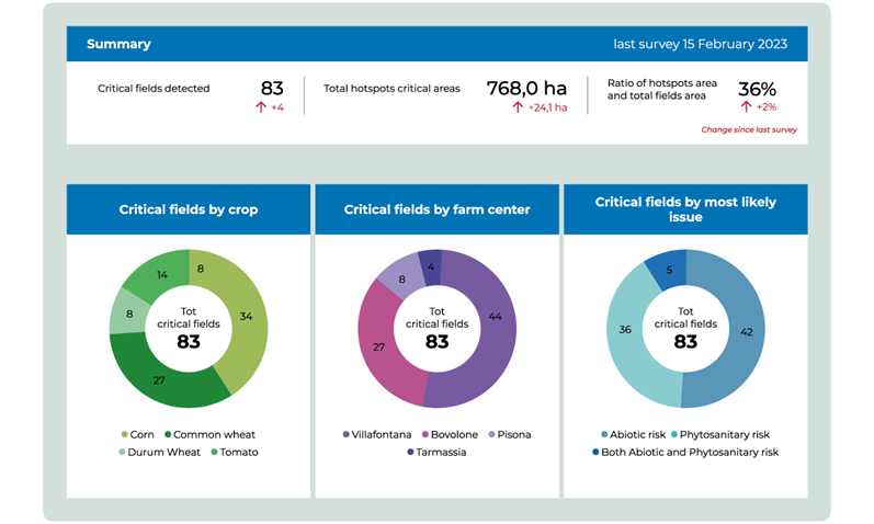
On this regard, the AgriTrack Full DSS stack can respond to their needs to take agronomic decision-making based on reliable and spatialised information, improve the monitoring and data collection from several fields and farms, and be able to obtain tangible and reported results on farm’s agronomical performance. This is completed by the possibility provided to users to have spatial and detailed alert information and its causes.
Lastly, from the interviews carried out with target users, the urgence to be trained and supported in the use of innovative and technological tools strongly emerged. Therefore, the commercial offer will include a module of one-to-one training on the use of the tool, while videos and tips have been included within the platform.
Italy and Spain.
The Full DSS is a functionality to be added to an existing cloud based FMIS. It will use all existing and new model outputs and sensed data (e.g., satellite, in-situ sensors) to obtain a probabilistic diagnosis of the abiotic agronomic issues affecting specific areas within the identified critical field. This information will be further enriched with alerts on pests and disease risk level.
This will be achieved by testing different Machine Learning and data-fusion approaches adopted as predictive tools within the large dataset that has been created by Agricolus in several years of smart farming experience. The AgriTrack Full DSS Stack consists of two modules. The first is a web application called Visualization Module, that displays sets of geospatial information and alerts, being the main interface and interaction point with the user. The second is the Computational Module, which produces such information and alerts combining different data sources into specific algorithms.
AgriTrack Full DSS is a new solution which brings four core innovations:
The project activities are successfully concluded. The product reached TRL 9 and it is ready for commercialisation.
All WPs have been successfully concluded, and the product performances reached the identified KPI to fulfill the Service Requirements identified during WP2000. The validation activities with users have been successful, confirming the novelty and market adequacy of the product.


 email
email  Facebook
  Twitter
  Linkedin
  Whatsapp
  Copy link