
 Data Processing & Visualisation
  Data Analytics, Insights & Applications
 HABTRAIL addresses the challenges posed by Harmful Algal Blooms (HABs), which impact aquaculture, public health, tourism, and insurance sectors. HABs contaminate seafood, disrupt aquaculture operations, cause economic losses, and pose risks to human health. Traditional monitoring methods rely on costly, time-consuming water sampling and lab tests, often leading to delayed responses.
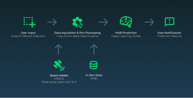
HABTRAIL provides an AI-driven early warning system that accurately predicts HAB occurrences and bivalve toxicity up to three days in advance. The platform integrates satellite and in situ data with advanced machine-learning models to deliver real-time insights.
Users access the predictions through a web dashboard, where they can visualise HAB severity, receive species-specific interdiction forecasts, and configure personalised alerts. Aquaculture operators can optimise harvesting schedules, public health offices can make informed safety decisions, and tourism and insurance entities can manage risks proactively.
By offering predictive analytics and automated alerts, HABTRAIL shifts HAB management from reactive to proactive, reducing financial losses, improving food safety, and ensuring sustainable marine resource use. The platform’s expansion will enhance its accuracy, cover more geographic regions, and incorporate additional environmental factors to support decision-making and regulatory compliance further.
HABTRAIL targets aquaculture entities, national regulatory bodies, public health offices, tourism businesses, and insurance companies. These customers face significant challenges due to Harmful Algal Blooms (HABs), which disrupt operations, endanger public health, and cause economic losses.
HABTRAIL directly involves these stakeholders by providing an AI-powered web dashboard with real-time predictions, automated alerts, and risk assessments, enabling data-driven decisions to mitigate the impact of HABs.
HABTRAIL initially targets Portugal for deployment, focusing on its coastline and estuarine zones. Expansion is planned for Spain, France, and Italy in Europe (Year 2), followed by the USA and Chile in the Americas (Year 3), and later Japan and South Korea in Asia (Year 4-5). These countries have significant aquaculture industries, regulatory bodies for marine monitoring, and coastal tourism sectors affected by Harmful Algal Blooms (HABs).
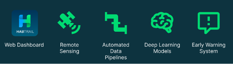
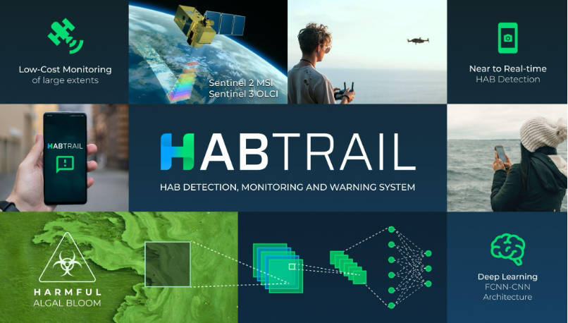
HABTRAIL is an AI-powered web-based platform that predicts, monitors, and issues early warnings for Harmful Algal Blooms (HABs). It integrates satellite data with machine learning models to forecast HAB severity and bivalve toxicity with over 90% accuracy for the next three days. Users interact with the platform through a web dashboard, where they can visualise HAB severity maps, access species-specific interdiction forecasts, and configure custom alerts via email or SMS.
By shifting from a reactive to a proactive approach, HABTRAIL ensures safer, more sustainable management of marine resources.
HABTRAIL brings significant added value compared to traditional monitoring methods and existing competitors by offering a proactive, AI-driven approach to Harmful Algal Bloom (HAB) prediction.
By transitioning from a reactive to proactive strategy, HABTRAIL minimises financial losses, improves food safety, and enhances environmental protection better than any existing alternative.
HABTRAIL has successfully completed its System Design, Integration, Site Acceptance Test (SAT), and Validation phases, with positive feedback from pilot users across the aquaculture, national entities and tourism sectors.
The platform is fully operational, delivering AI-driven three-day forecasts for species interdictions, pixel-based HAB probability, CHLOR_A, and SST, alongside complementary environmental layers such as salinity, pollution, sediments, tides and weather. The web dashboard provides real-time visualisation, historical trends, and customisable email/SMS alerts.
Geographic coverage has expanded from the initial Algarve (L7C2) test zone to the entire Portuguese coastline and estuaries. The Validation Phase confirmed the operational relevance of the service, supporting forecast assessment, model robustness evaluation and dashboard usability testing under real user conditions.
The project has therefore reached its final technical and validation baseline and is now progressing toward Final Assessment and commercial rollout.

 email
email  Facebook
  Twitter
  Linkedin
  Whatsapp
  Copy link