

 Data Analytics, Insights & Applications
 BODIS offers long-term accurate predictions of surface and asset motions, and its associated flood risk for asset portfolios. All buildings and/or engineering structures are subject to land subsidence and flooding, making them vulnerable for these processes. During floods, besides the societal impact, these assets face huge financial risks due to the sagging of these structures and the associated flooding. Therefore, asset owners and financial stakeholders benefit from insights into these risks, especially in the light of future climate change effects.
The service is built upon InSAR data and hydrodynamic simulation software, suitable for simulations of flooding and drought scenarios, keeping climate change in mind. Specifically, BODIS provides insights in the risk of customers’ asset portfolios (such as individual buildings and engineering structures) and the potential economic impacts they face when flooded. The forward prediction algorithms are integrated with hydrodynamic flooding scenarios and made available for the end-user in an easy-to-use visualisation platform, allowing decision-makers or portfolio owners to make better informed decisions.
Organisations that benefit the most from the information service BODIS are mainly large property owners that report yearly on their amount of assets at risk and the value of these properties.
For example, these values are used for taxation, insurance purposes or need to be compliant with climate agreements. Housing corporations let or sell homes to low-income citizens, older or disabled people. In the Netherlands, they administer tens of thousands of assets (buildings) in potential flood risk areas, such as the floodplains. Furthermore, insurance companies need to calculate the risk due to flooding or land-motion to set the correct profit margins for their policies. The last targeted customers are banking entities which own large volumes of real estate assets who want to be informed of flood and land-motion risks and how these risks devalue the price of these assets.
BODIS can be developed and deployed globally. Initially, the targeted customers are located in the Netherlands, but the product is scalable (and developed) to be deployed in countries globally.
BODIS is an innovative platform, designed to customers’ needs, where users have access to the most actual subsidence and flooding data. Furthermore, prediction algorithms for land-motion and hydrodynamic simulations predict propagation of floods for future scenarios. As such, end-users obtain new information of the altered risks of their asset portfolios, with future climate scenarios incorporated.
Organisations are adapting to the effects that result from climate change, such as more extreme weather events, rising sea-levels and soil subsidence. Most organisations use their own tools and datasets to set-up their own risk models, which they offer to their clients. However, the added value of BODIS is the integration of future land-motion and the associated flood risks and its translation to value at risk. Additionally, information on asset level is usually not available (only on larger scales).
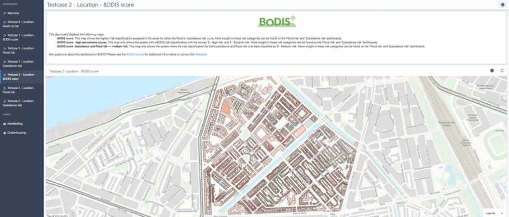
With BODIS, end-users obtain information on three different levels to characterise the risks to their asset portfolio in a specific region. BODIS is updated with new scenario information instantly and can be tuned to end-users needs.
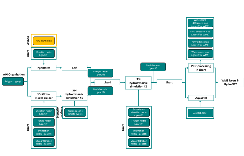
BODIS is a development of a new type of information service that integrates results from existing systems such as SkyGeo Antares processing services, 3Di Water Management from Nelen & Schuurmans and customises these results in the platform HydroNET from HydroLogic. Each product exists in the market and successfully provides different services in several markets, such as water management, spatial planning or the subsidence business.
This project, now completed, started in 2019 with an innovation call (SBIR) by the Dutch National Space Agency (NSO) and resulted in a prototype for a flood-and-subsidence information service. Currently, a forecasting module for subsidence rates, an automatic model-builder for hydrodynamic schematisations, an automated flooding-simulator and post-processing module (AquaEval) to derive risk classifications for individual assets and disciplines is developed in the BODIS project. All this information is showcased in an information platform.


 email
email  Facebook
  Twitter
  Linkedin
  Whatsapp
  Copy link