

 Data Analytics, Insights & Applications
 Increasing drought issues impose a threat to farmers and food security worldwide. Therefore, irrigation is crucial to ensure high and stable yields. Reliable irrigation advice helps to improve food security, farmers’ income, and reduce the use of water. However, the problem with generating irrigation advice is that it demands a lot of input from the farmer like information on numerous soil and crop parameters. On top of that, the information required tends to deviate towards the end of the growing season. Each model has a niche, but no model works best for all crops in the different regions. Using in-situ soil moisture sensors faces many limitations, such as costs and the point-based nature of the observations.
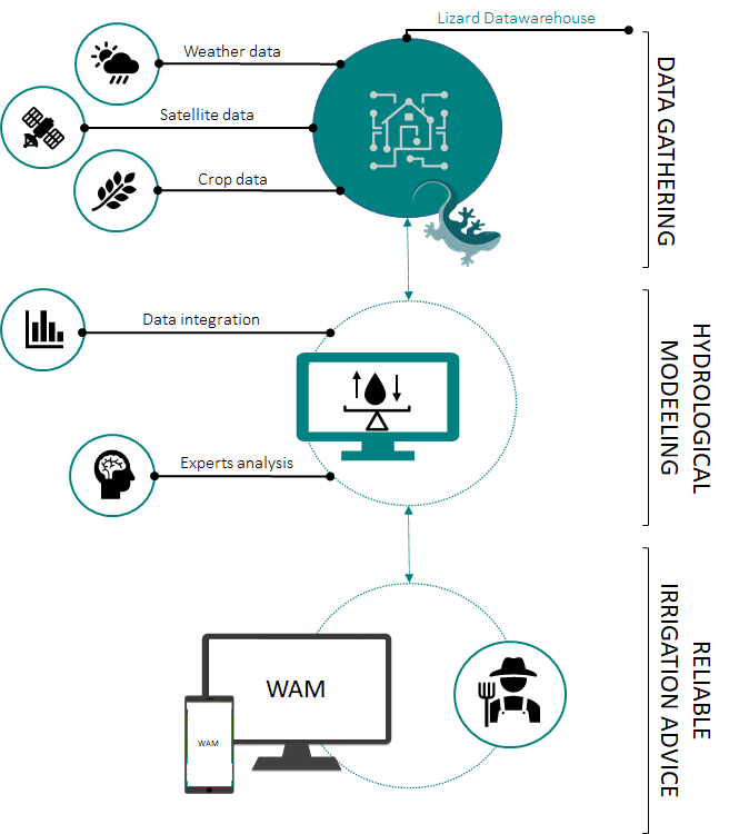
Three Dutch tech partners have joined forces to support farmers in fighting drought problems by providing a state-of-the-art irrigation advice service, named the WAM. The WAM uses the best available climatic, soil and crop datasets required for a certain use. The model adjusts the input available, and uses EO data assimilation to ensure accurate advice. This product is available to any user in Europe who can add new datasets or parameters to ensure that WAM provides customised advice to any farmer.
The WAM product is targeted at arable farmers throughout Europe. The activity has started to identify the needs of farmers in The Netherlands, Belgium and Portugal to understand their regional diversity. Farmers have been interviewed, tested the product, and provided feedback on the prototypes. The accuracy of the output is also tested with historic as well as present data for different crops in the plots of existing customers.
Farmers are especially focused on accuracy, user friendliness and economics. If the product provides accurate and actionable insights on-the-fly, it is well received. The less user input required throughout the season, the better. WAM is especially focused on accuracy, as many are still sceptical about using satellite images to monitor sub-surface conditions.
Netherlands, Belgium, Portugal, and eventually all of Europe
WAM provides updated irrigation advice daily. This is based on VanderSat’s daily soil moisture maps at 100m resolution. Sensor combination and intelligent downscaling provide accurate plot-level information.
The crop-water-balance is a modular structure, in which the best available data is used under any circumstances. This ensures that our advice can be provided for almost any crop in most regions, while the output is still as detailed as possible. The product aims to be scalable to at least the European level in 2021, and globally by 2023. The WAM should provide clear economic and environmental benefits for farmers.
The products innovation lays in its ability to create soil moisture maps and custom-made hydrological models. Proven concepts are also used to form a good understanding of user requirements based on many years of experience. Crucial in this are speed, accuracy, intuitiveness, and transparency. All underlying processes, such as crop development, can be visualised by the farmers. This means the product can be used for irrigation advice and more general crop monitoring. All results are actionable, providing a clear and realistic schedule.
The WAM approach requires limited farmer input to provide accurate advice throughout the season. Models that exclude soil moisture observations tend to deviate towards the end of the season, that is generally the driest period in which accurate insights are most needed. Our option is more affordable than in-situ sensors which only provide information at certain locations and have a limited life-span. Other remote sensing models either require cloud-free images for a certain percentage of the season, or have a lower spatial and/or temporal accuracy.
WAM uses the best possible data for each user. Each component of the model is based on a stack ranking of underlying datasets. More datasets, such as local weather stations or in-situ sensors, can be added depending on availability. Ranking can be changed depending on validation with farmers’ demand.
The product models crop growth in a dynamic way based on climatic conditions. This is important as climatic variation can easily result in an advancement or delay of the ‘standard’ modelled crop development by a couple of weeks. VanderSat provides the best available soil moisture insights in both temporal and spatial dimensions, enabling WAM to provide accurate results for most crops in any requested region.
The product development is completed. All datasets and connections are operational and feedback is available in a user interface. Firstly, we have tested the accuracy with historic datasets on plots for which there is an irrigation schedule. This activity has showed that the products advice schedule improves the schedule compared with what farmers have done in areas in which no restrictions were placed on the use of water. The test cases show promising results on the benefits it brings to farmer in terms of water use, yield quality and irrigation cost-savings.
Secondly, the year 2021 was dedicated to a pilot year where the product was tested operationally with a group of farmers. During this pilot operational advice was given to the subscribed farmers and feedback was gathered in terms of the provided information and user experience. After the conducted pilot year a technical validation was executed to test the product with field data. The study shows that the modelled water availability is in line with in-situ sensor data.
The product design and user requirements are selected and improved based on farmer interviews and feedback during the pilot year. All required datasets (e.g. soil moisture, crop database and soil characteristics) are operational, and a custom hydrological model has been developed.
The WAM marketing campaign has started and includes creation of awareness on social media and showcasing the economic rationale among others.
Currently, final pilot cases are conducted in collaboration with major Dutch agribusinesses while we prepare for the soft launch. The soft launch of the WAM irrigation service is scheduled for mid-2022, with its first clients using the service in the growing season of 2022.

 email
email  Facebook
  Twitter
  Linkedin
  Whatsapp
  Copy link