
 Data Analytics, Insights & Applications
 VALUESAFE fills an important gap for companies and public institutions responsible for buildings and properties by helping communities and businesses understand and prepare for the financial impact of natural disasters like earthquakes, landslides, and floods.
VALUESAFE faces the challenges of risk and losses prediction by using satellite data, maps, and digital images. It offers a faster, accurate, affordable, and cutting-edge assessment of building vulnerability leveraging satellite data and AI, reducing reliance on slow, costly inspections.
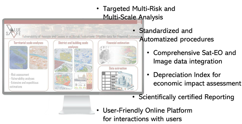
Through a simple online platform, users can request custom risk analyses and receive detailed reports that estimate possible damage and loss in value, making complex data accessible to a wider audience. These data help them make informed decisions about insurance, maintenance, and disaster preparedness, ultimately protecting their assets. By combining many data sources, VALUESAFE aims to make advanced risk assessment understandable and actionable, leading to safer, more resilient properties and communities.
VALUESAFE is designed for public and private groups responsible for managing and protecting different building stocks, including cultural heritage sites. Private clients, like insurance companies and asset managers, need reliable, science-based risk data to guide business strategies and reduce unexpected losses.
Meanwhile, public agencies can use VALUESAFE’s insights to prioritise mitigation actions, allocate resources, and plan safer communities. Both groups struggle with finding affordable, accurate risk evaluations that don’t require time-consuming, costly site visits. VALUESAFE’s online platform addresses these needs by offering tailored, easy-to-understand reports and a straightforward interface.
This setup allows users to access vital risk information and connect directly with experts, helping them focus on long-term planning and resilience while saving time and resources.
Italy and Europe.
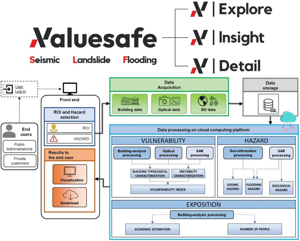
VALUESAFE provides an online portal that enables users to access services, customise risk assessment requests, and manage outputs related to property vulnerabilities, risk and expected depreciation of buildings against natural disasters (earthquakes, floods, and landslides).
VALUESAFE is established on three tiers (Explore, Insight, Detail) based on increasing levels of accuracy and precision to target different users’ segments. To achieve this, VALUESAFE integrates three core evaluations: vulnerability assessment, analysing building characteristics that influence risk levels by employing digital and satellite imagery; hazard assessment, utilising recognised maps and satellite data to determine the probability and intensity of events; exposure evaluation, which measures the number of people, economic value, and cultural significance of assets in affected areas using national census data and expert insights.
VALUESAFE synthesises this information into accurate risk estimates and economic impact scenarios. This scalable solution provides crucial insights for diverse users and territorial extents – from public administrations managing large regions or critical infrastructure (schools, hospitals, heritage sites) to private insurers and investors – enabling informed decisions on asset management and disaster preparedness.
VALUESAFE delivers added value through its reliable, expert-certified analyses that standardise vulnerability assessments on a global scale. By integrating diverse data sources, VALUESAFE provides a comprehensive understanding of building vulnerability, saving time and resources while delivering robust, replicable analyses directly applicable to business and regulatory decisions.
Unlike competitors that rely on outdated or non-site-specific data, VALUESAFE utilises advanced satellite data, interferometric analysis, and crowdsourced ground monitoring to produce up-to-date evaluations of multi-risk vulnerabilities across various real estate assets. This unique approach ensures that stakeholders receive the most relevant and timely information for informed decision-making.
Additionally, VALUESAFE’s user-friendly digital platform enhances this value proposition by allowing users to customise analysis targets, detail levels, and outputs to meet their specific needs. This flexibility and responsiveness ensure timely, detailed insights into risk and economic impacts, particularly for municipalities with rich cultural heritage, supporting vital economic development.
By focusing on a comprehensive approach, advanced technology integration, and user-centric design, VALUESAFE distinguishes itself in the competitive market for risk assessment solutions. This positions the service as a leader, driving significant progress in climate resilience and sustainable development efforts while enriching the overall customer experience and fostering long-term partnerships.
VALUESAFE successfully passed the Preliminary Design Review (PDR) milestone in May 2025 and has now reached its final milestone with the conclusion of the De-Risking Phase.
Critical modules and processing chains – encompassing Earth Observation, AI, and risk modelling – together with computation workflows for the three service levels (Explore, Insight, Detail) and for multiple hazard types (Seismic, Landslide, Subsidence, Flooding), have been architected, functionally decomposed, and implemented.
The project has delivered a complete and validated multi-hazard risk assessment platform that demonstrates the integration of EO data, AI-driven image analysis, engineering-based risk modelling, and economic loss estimation into a coherent, user-oriented service.


 email
email  Facebook
  Twitter
  Linkedin
  Whatsapp
  Copy link