
 Data Processing & Visualisation
  Data Analytics, Insights & Applications
 More than a million kilometers of high-pressure pipelines, often buried underground, run through countries supplying gas and energy to businesses and communities worldwide. These pipelines are subject to various risks such as unauthorised construction by third parties, geohazards or agricultural activity.
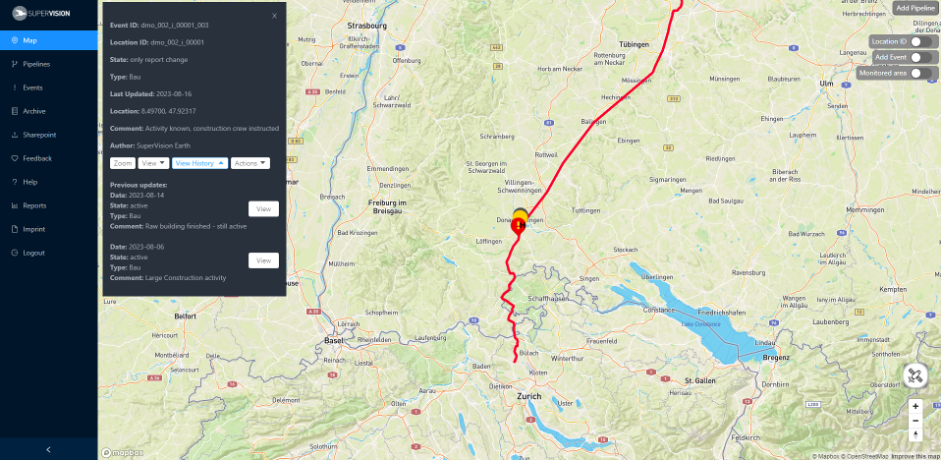
SuperVision Pipeline (SVP) is a pipeline monitoring solution which uses proprietary AI algorithms to analyse satellite and drone data, to detect and regularly report on various risks to infrastructure. The algorithms behind SVP process latest images from various sources for timely and accurate risk detection.
The SuperVision Pipeline monitoring solution is designed for operators of critical infrastructure. The protection of underground infrastructure is a complex task and incidents, while rare, can cost millions. Regular satellite and drone monitoring of pipelines can help pipeline operators spot risks before they become incidents and comply with regulations.
Operators of critical infrastructure, transmission system operators (TSOs) globally.
Our product comprises a sophisticated satellite and drone risk detection system, offering a viable alternative to traditional helicopter monitoring. Key components include a cloud-based backend for acquiring and processing imagery from multiple sources, advanced AI models for risk detection, and a user-friendly web-GIS application for displaying detected risks.
SuperVision Pipeline stands out with its 99% greater carbon efficiency compared to conventional helicopter monitoring methods. By transitioning to satellite and drone-based monitoring, we drastically reduce CO2 emissions, contributing to environmental sustainability while ensuring effective risk detection.
Starting in September 2022, we expanded our product offerings to include drone monitoring, fulfilling the evolving needs of our customers. Spearheading the research in remote sensing, the TU Darmstadt and University of Würzburg have been onboarded as further consortium partners. Our achievements in research and innovation have been recognised with the publication of our AI development findings in the esteemed journal “Remote Sensing” with the title “Effective Risk Detection for Natural Gas Pipelines Using Low-Resolution Satellite Images”.
Throughout the development phase, our consortium partners rigorously tested and validated the SuperVision Pipeline solution, receiving monthly updates via our intuitive Web-GIS application. Collaborations with regulatory authorities such as DVGW ensured industry expertise and compliance.
In January 2024, we successfully concluded the InCubed product development cycle of SuperVision Pipeline, marking it as a market-ready product. We secured a long-term contract with a leading German pipeline operator, affirming the product’s readiness and efficacy.

 email
email  Facebook
  Twitter
  Linkedin
  Whatsapp
  Copy link