 Data Analytics, Insights & Applications
 SmartDig, a service based on AI, provides accurate preventive archaeology, a legal requirement for businesses and organisations undertaking construction affecting ground. Detection of surface and sub-surface features helps Cultural Heritage professionals extracting information about potentially buried archaeological remains, reducing waste of time, money due to unplanned delays and avoiding the loss of
valuable historical structures.
The targeted customers for the SmartDig service include professionals involved in public or private construction projects, such as project managers, architects, engineers, and urban planners, who must comply with legal obligations to safeguard Cultural Heritage (CH) and archaeological sites. These stakeholders are involved in various stages of project development, including the design, planning, and execution phases. Their primary need is to ensure that any archaeological features in the area are preserved without causing significant delays or cost overruns to their projects.
Current challenges include the time-consuming process of non-invasive archaeological analysis, which can take up to six months and increase project costs. This delay is due to the extensive retrieval and analysis of photographic and satellite data. Moreover, the complexity of navigating legal frameworks, such as the “Verifica Preventiva dell’Interesse Archeologico” (VPIA), adds further constraints.
SmartDig addresses these challenges by offering a faster, more efficient service for conducting preventive archaeology analyses. By simplifying access to crucial geospatial and archaeological data, SmartDig helps professionals reduce the time and cost associated with the preliminary assessments, enabling smoother project execution while maintaining the integrity of CH sites.
The SmartDig service initially targets customers and users in Italy, where legal requirements like “Verifica Preventiva dell’Interesse Archeologico (VPIA)” ensure the protection of Cultural Heritage (CH) during construction projects. However, the service is designed to be adaptable and can be applied across Europe and the rest of the world. It is relevant for any region committed to preserving CH and archaeological features during development activities. Many countries have similar legal frameworks or guidelines for protecting heritage sites, making SmartDig valuable for professionals in public and private sectors globally. The service can assist any country or region seeking to streamline the archaeological assessment process while maintaining a strong commitment to CH preservation.
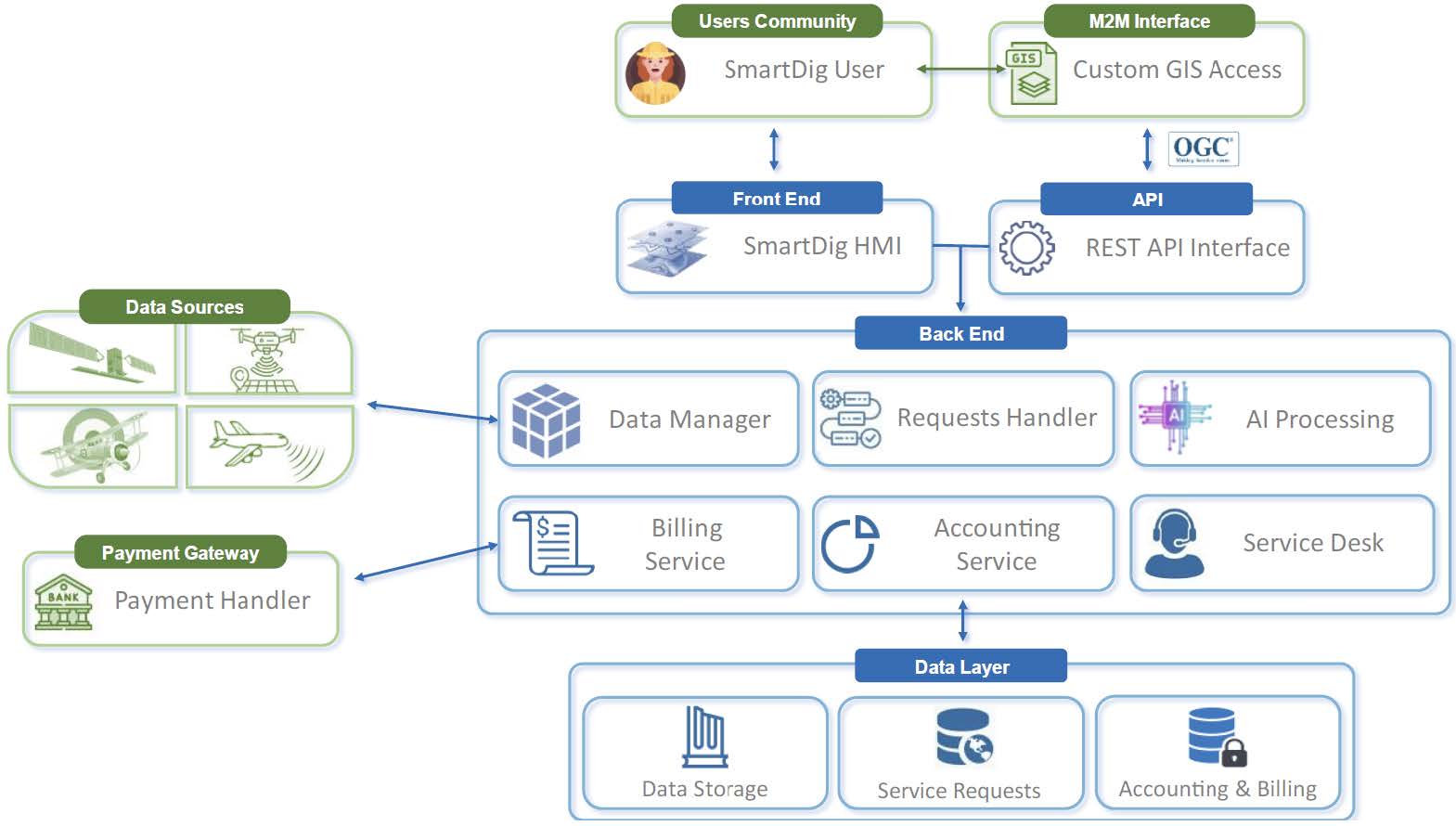
SmartDig is an innovative, GIS-based web application designed to streamline preventive archaeology. The tool leverages Artificial Intelligence (AI) and Earth Observation (EO) data to conduct multi-temporal analyses, identifying potential buried archaeological features. This enables SmartDig to detect vegetation, soil moisture, and surface anomalies—such as crop marks, soil moisture marks, and micro-relief—that indicate buried remains.
One of SmartDig’s key innovations is its multi-temporal analysis, which enables users to track seasonal changes and compare data over time, improving the accuracy and reliability of anomaly detection. This system replaces traditional, manual methods, providing results more quickly and consistently while reducing errors. The service offers spot-on-demand analysis or subscription-based access to recurrent analyses, as well as API integration for expert users needing seamless integration with GIS or EO tools.
Users interact with SmartDig through an intuitive web platform. They can upload their Area of Interest (AOI), customise the analysis (e.g., spatial resolution, accuracy), and receive results in an accessible format. SmartDig reduces the time needed for preventive archaeological analysis, offering a more accurate, non-invasive, and cost-effective solution to safeguarding cultural heritage during construction projects.

SmartDig brings substantial added value compared to existing competitors by addressing the limitations of traditional preventive archaeology methods. Competitors often rely heavily on manual inspections or high-resolution drone-based imagery, which, while detailed, are costly, time-consuming, and limited in coverage. Drones may provide excellent resolution in small areas but struggle with large-scale projects due to the time and expense required to survey vast regions.
SmartDig, on the other hand, uses AI-driven analysis of Earth Observation (EO) data from satellites, enabling rapid, large-scale, multi-temporal analysis. This approach not only allows for the identification of a wider range of archaeological features, such as crop marks and soil moisture marks, but also minimises the need for costly and slow on-site inspections. Additionally, SmartDig’s ability to analyse historical EO data offers a significant advantage over competitors that rely on real-time data alone, as it can detect changes over time that may indicate hidden features.
The SmartDig project is progressing well with several key steps already achieved. We have successfully engaged multiple stakeholders, including archaeologists, researchers, and professionals in the construction industry, to gather in-depth user requirements. This engagement has provided valuable insights into user needs, allowing us to refine the service accordingly.
The preliminary analysis of the best AI architectures is underway, focusing on identifying models that can efficiently process EO data and detect archaeological features with high accuracy. Additionally, preliminary test sites have been selected—some areas with well-known hidden structures and various types of anomalies. These sites will serve as a crucial benchmark for testing the service’s performance.
We have also started assessing the best combinations of EO data for anomaly detection, evaluating different satellite data sources (e.g., LiDAR, SAR, optical) to determine the most effective options for identifying buried archaeological features. These efforts are laying the foundation for further development and testing.