
 Payload
  Ground Stations & Mission Management
  Ground Networks & Data Distributions
  Data Processing & Visualisation
  Data Analytics, Insights & Applications
 Skymetry’s cutting-edge monitoring services are designed to revolutionise how assets are managed across various industries. Leveraging advanced remote-sensing technologies, Skymetry offers accurate, scalable, and cost-effective solutions. Skymetry’s mission is focused on fusing together advanced remote-sensing technologies and AI annotations to assess and monitor large assets in the Energy, Infrastructure and Urban domains.
While supporting owners in safeguarding asset integrity and managing site control and planning, Skymetry also plays a key role in evaluating the environmental sustainability of these resources, determining the potential impacts these assets can generate on the surrounding territory.
Benefits:
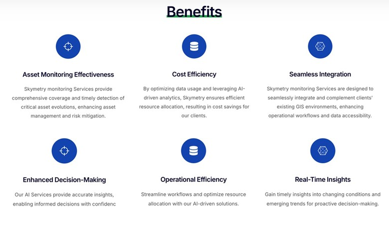
Skymetry’s solutions are tailored to meet the specific needs of each served industry vertically.
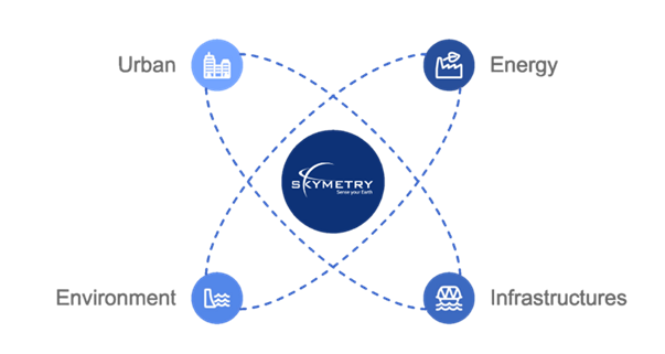
Skymetry Services have been tailored according to vertical user-needs expressed by operators within the Energy, Infrastructure, Environmental Protection and Urban Planning domains.
Thanks to the experience acquired by DigiSky over the past 10 years, Skymetry’s uniqueness lies within the native integration and combination of all possible EO sources into a single end-to-end SaaS platform that competitively delivers insightful 4D AI-enabled reports, which can be directly integrated into the operational workflows of infrastructure owners and governmental agencies.
In the Energy sector, Skymetry Services optimise infrastructure monitoring in the power generation and transportation, contributing to their sustainability and efficiency.
In the Infrastructure domain, Skymetry Services provide in-depth inspections to ensure resilience and safety. In pre-construction phases, Skymetry provides accurate Digital Twins which are at the foundation of the digital design and simulation.
Thanks to Skymetry Environment solutions, ecological changes can be monitored to safeguard natural resources and assess hydrogeological risks.
In Urban Planning, Skymetry empowers the envisioning of how the “as-built” context can be evolved while extracting BIM-ready models. Skymetry Services ensure that clients gain actionable insights to improve operations and achieve sustainable outcomes.
The Skymetry SaaS product is designed to serve four primary customer segments:
Clients in these sectors can benefit from Skymetry’s user-friendly web-GIS interface to place georeferenced orders to monitor their assets.
By integrating EO data, Skymetry ensures continuous monitoring of areas of interest, while acting as “magnifying lens”, whenever required.
Through advanced change-detection AI algorithms, the aerial inspections are triggered, using certified general aviation aircrafts equipped with high-resolution sensors (RGB, SAR, TIR, LiDAR, Hyper-Spectral). This combination of EO sources and observation bands enables superior monitoring insights, while optimising operations time and costs through selective and automated data-gathering strategies. Besides relying on existing EO sources, Skymetry competitively supports innovative spaceborne payloads vendors and upstream nano-satellite OEMs with atmospheric testing, de-risking and calibration services (SkyGate), thus contributing to the development of the EO upstream segment in New Space Economy.
Skymetry provides advanced monitoring services that combine satellite, aerial, and AI-driven technologies to offer precise, real-time insights for industries operating in the energy, infrastructure, environment, and urban planning fields.
Skymetry Services enable the transition from traditional ground-based monitoring methods to remote-sensing practices, by providing an integrated virtual inspection environment co-piloted by AI.
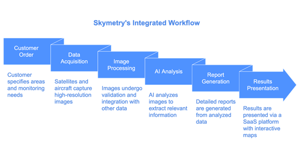
Skymetry is an integrated end-to-end SaaS solution for monitoring operations that automatically tasks the most suitable EO sources relevant to the target asset and release AI-based reports that co-pilot very-high-definition virtual inspection operations within an integrated web-GIS environment.
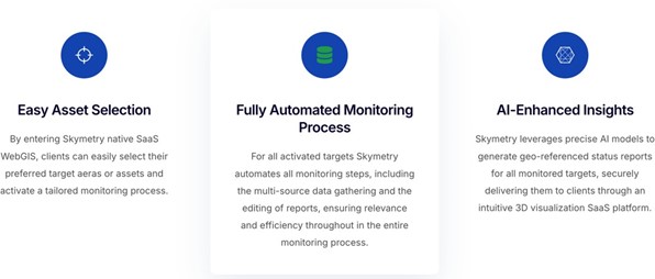
Skymetry acts as an end-to-end solution with various advantages:
This activity is completed.
DigiSky has been capable of obtaining noticeable achievements over the years in its core markets and in various regions.
Having designed and certified a proprietary avionic solution (SmartBay®) which enables any general aviation aircraft to be easily transformed into a special mission airborne data-gathering tool, DigiSky has enabled the possibility of rapid geographical scalability of aerial operations through affiliated partners, to complement available EO sources.
Skymetry Services are currently addressing commercial and pilot programs in the following domains and regions:
In Solar Power generation, Skymetry is steadily serving over 4GW of installed capacity across Europe.

 email
email  Facebook
  Twitter
  Linkedin
  Whatsapp
  Copy link