 Data Processing & Visualisation
  Data Analytics, Insights & Applications
 National weather services and private weather companies can get many-fold more data than today from each weather balloon launch. These data contribute to more accurate weather forecasts.
This Tropospheric Satellite measures wind (including gusts and turbulence), standard pressure, temperature, and humidity variables. The main added feature is Airborne Radio Occultation, giving on average about 10 extra sensor-grade vertical profiles of temperature, humidity and pressure. As extra variables, it also measures infrared, visible light and UV-B radiation, and, optionally, air quality. The tropospheric satellite is standardly sold as a hardware product.
We also sell higher-level processed meteorological data. As a particular feature, AI and data fusion algorithms are being developed during the project. Data are processed with machine learning-based data fusion from other weather data sources, notably EO satellite data, to give more accurate weather data than what it is accomplished with Airborne Radio Occultation alone.
The solution serves both public and private sectors, targeting national weather services (including storm measurement operators and climate/weather researchers), as well private weather instrument companies. The fundamental value proposition is simple: obtaining more upper-air weather data at very little extra cost.
In other words, meeting the urgent demand for filling important upper-air data gaps by using infrastructure and weather balloons that would be launched anyway. This leads to better weather forecasts and multiple societal benefits.
The solution will be piloted with customers from Europe and USA.
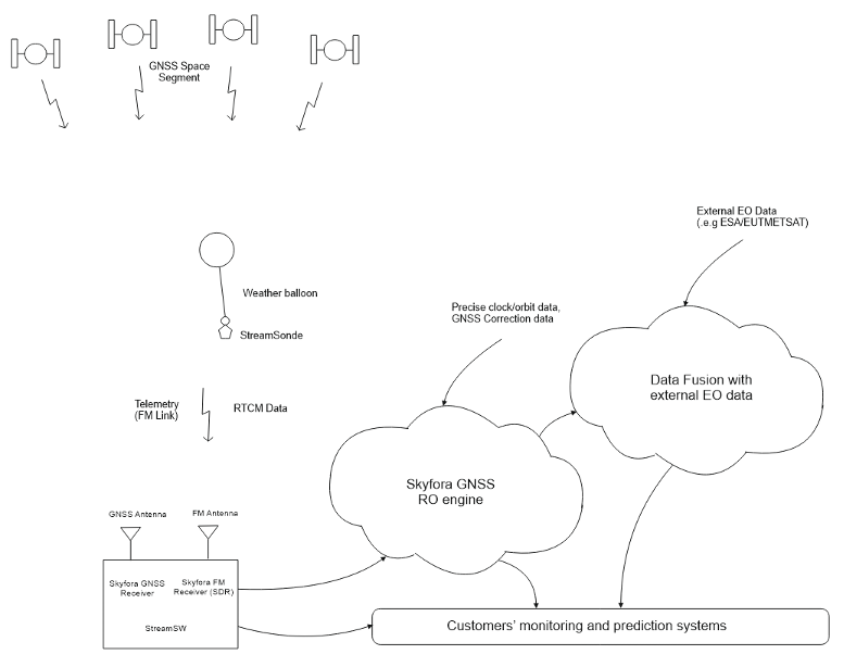
The main building blocks are:
The role of the Tropospheric Satellite, in the context of the overall system of its target users, is as part of a weather observation network, typically comprising a diverse suite of different instruments. The main new feature developed for the hardware is the ARO capability from the existing GNSS receiver.
The dual-band GNSS antenna (dipole) used in the StreamSonde/Tropospheric Satellite is excellent for ARO from weather balloons, as the main lobe of the antenna has a maximum in the horizontal directions, capturing low-elevation signals with maximum signal-to-noise ratio. Typical tilt angles for the Tropospheric Satellite attached to the balloon with a string are +/- 30 degrees during ascent. These angles are still within the main lobe of the antenna (antenna gain 0 to 1.72 dBi).

With our solution, it is possible to obtain more upper-air weather data at very little extra cost. RO profiles from LEO satellites are worth at least €5 per profile. The ‘remotely sensed profiles’ are worth clearly less per profile than actual radiosonde profiles, but when adding all the extra profiles up, we get at a minimum of about €50 in commercial benefits for essentially the same radiosonde unit costs after an initial R&D investment. Typical studies also show that €1 invested into weather technology is returned to €5-7 of societal benefits, making the overall societal value greater than the commercial sales value.
By optimising the balloon, the Tropospheric Satellite can float for longer periods of time, even up to several days, further multiplying the benefits. Longer-living stratospheric or high tropospheric balloons may multiply the factor.
Moreover, as the Tropospheric Satellite’s data is processed with state-of-the-art GNSS processing algorithms and AI and data fusion methods, the accuracy and fraction of high-quality data will improve. Using advanced pattern recognition algorithms, refractivity profiles can be intelligently decomposed to their temperature, pressure and water vapor constituents, in a more precise way when using external EO data, and deeper into the troposphere than is currently possible.
The Tropospheric Satellite project has successfully completed the Requirement Review, marking a key milestone in aligning mission objectives, system specifications, and user needs. It is now advancing into the development work packages within the de-risking phase. This stage will focus on the technical implementation and validation of critical components to ensure performance and feasibility ahead of full-scale development.
