
 Data Analytics, Insights & Applications
 Crop insurance faces several challenges that can affect its effectiveness and sustainability. One significant issue is the inefficiency and high costs associated with loss adjusters. The process of assessing crop damage often relies on manual inspections, which can be time-consuming, inconsistent, and prone to human error.
Saturnalia leverages cutting-edge satellite technology to provide daily monitoring and analysis of agricultural crops. Its service offers near real-time insights into crop health, growth patterns, potential issues and damage assessment, enabling growers and crop insurance companies to make informed decisions swiftly and accurately.
Insurance companies benefit from Saturnalia’s technology to better estimate risks, manage claims, reduce fraud, and assess damage from natural disasters. The potential for transformation in these traditionally conservative industries is immense. The Saturnalia monitoring service is a tool for insurance companies to quickly assess the extension of damage and support the loss adjusters’ activity in the field.
Insurance companies need to support experts in correctly assessing damage caused by natural events (hail, frost and excess of water). They also need prompt access to weather data for damage assessment. Moreover, they need to measure risk associated with every single parcel crop.
Saturnalia HFE’s targets are crop insurance companies operating in Europe, especially in Italy.
Saturnalia aims to become a reference to help loss adjusters in the field. Our plan is to use satellite imagery to support crop insurance activities. Automatic damage assessment is not available on the market as it requires data, know-how and continuous interaction with end-users to be built. Loss adjusters are going to use the Saturnalia app to collect data in the field, providing a constant feedback flow.
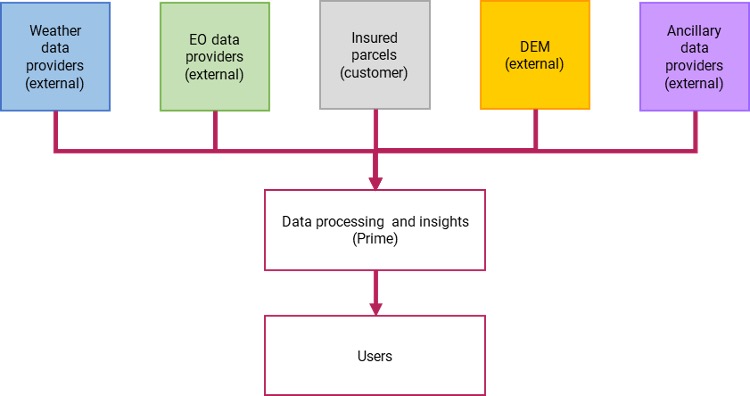
Saturnalia HFE stands out as it has built, together with the leaders in the agriculture insurance market, a full suite of tools to fill the data gap in the crop insurance value chain: from daily satellite monitoring to a GIS platform to manage portfolios and an app for data collection in the field, Saturnalia HFE is covering every aspect of the value chain. Its main added value is the strong connection with the end users and fast response, given the customers’ feedback. Data from satellites enable an objective measurement of anomalies, leaving loss adjusters to focus on the other operations, improving throughput and accuracy.
The project is running at maximum capacity. The Critical Design Review was positive, and the project is progressing fast. Interaction with insurance companies and brokers has been very intensive and feedback has been used to improve the products. Needs have been identified and implemented in order to get closer to product-market fit.
Two new contracts with customers have been signed. Saturnalia was present at the 7th International Forum on Risk Management in Agriculture held in Rome. Saturnalia was also invited to private events with re-insurers to present the solution. On the technical side, the team has completed the first iteration of the excess of water model and is currently refining the same product for frost. The team is also developing the second version of the hail detection module. The Factory Acceptance Test meeting is planned for January 2026.

 email
email  Facebook
  Twitter
  Linkedin
  Whatsapp
  Copy link