
 Platform
  Ground Stations & Mission Management
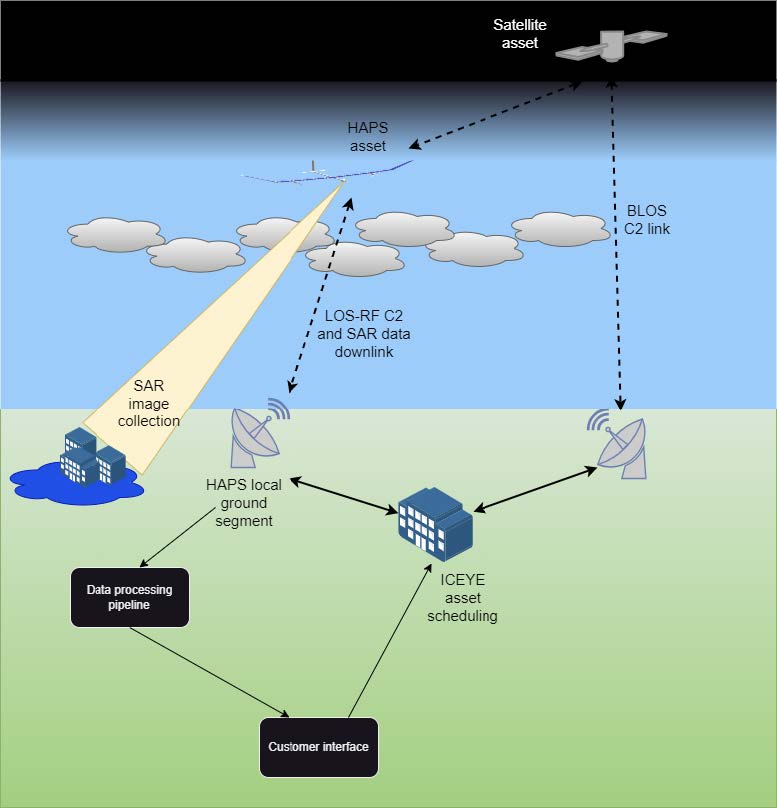
 HAPSEYE is an ESA InCubed-supported project led by ICEYE Spain to develop a solar-powered High Altitude Pseudo-Satellite equipped with a SAR payload. Operating at more than 20 km in altitude, HAPSEYE complements ICEYE’s satellite constellation by providing continuous monitoring with near real-time data transmission.
Through a series of incremental prototypes, the project advances towards a Minimum Viable Product (MVP) at TRL7. HAPSEYE enhances Europe’s autonomy in Earth observation, bridging gaps left by satellites due to limited revisit rates or capacity bottlenecks. Its applications include disaster response, flood and wildfire monitoring, and national security.
This activity consolidates ICEYE’s Spanish hub in Valencia, creating new high-skilled jobs and strengthening the European aerospace supply chain. With support from ESA, national regulators and key customers HAPSEYE is positioned to become the first European SAR-tailored HAPS platform, delivering unique added value in resilience, flexibility, and cost-effectiveness.
HAPSEYE targets government agencies, emergency management organisations, insurers, reinsurers, and defence entities. These customers require persistent, timely, and reliable Earth observation data to support disaster management, infrastructure monitoring, and security operations.
Insurance and re-insurance customers have expressed strong interest in validating HAPSEYE results during development. Governments require enhanced situational awareness during crises.
Spain, Greece, USA, Australia, Japan.
HAPSEYE is a solar-powered unmanned aerial platform designed to operate in the stratosphere for months at a time. It carries a Synthetic Aperture Radar payload, providing near-continuous coverage of selected regions with very high resolution.
Main features:
Innovation aspects: dedicated SAR-only payload, agile prototyping cycles, and European development (avoiding ITAR restrictions). Customers interact via ICEYE APIs, portals, or tasking services, integrated with existing data pipelines
HAPSEYE uniquely combines persistence, high-resolution imaging, and resilience:
The integration with ICEYE’s SAR constellation and Solutions products makes HAPSEYE a key enabler of faster disaster response and improved risk assessment. Its European development secures autonomy in critical Earth observation capacity.
Kick-off meeting held on 30 July 2025.


 email
email  Facebook
  Twitter
  Linkedin
  Whatsapp
  Copy link