
 Data Analytics, Insights & Applications
  Data Processing & Visualisation
  Ground Networks & Data Distributions
 Municipalities and businesses across Europe face growing climate risks — floods, wildfires, droughts, heatwaves, cold snaps — but lack the tools to act. Current systems rely on outdated, fragmented data that cannot predict compound hazards or justify adaptation investments. Decision-makers struggle to translate satellite observations into actionable strategies, leaving communities and supply chains vulnerable.
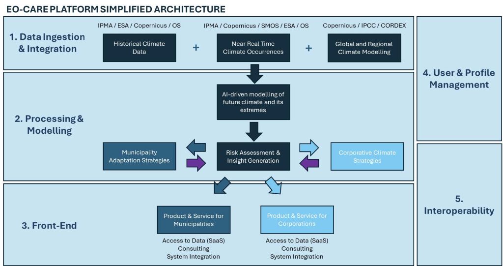
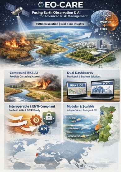
EO-CARE solves this by combining near-real-time Earth Observation data from Copernicus satellites with AI-driven climate models to deliver hyperlocal risk assessments at 100-meter resolution. The platform enables municipalities to map heat islands, monitor coastal erosion, and simulate the cost-effectiveness of green infrastructure. Businesses can assess supply chain vulnerabilities and comply with climate disclosure frameworks like TCFD.
Unlike generic tools, EO-CARE integrates historical hazard registries with IPCC climate scenarios, predicting cascading events — such as drought-fueled wildfires triggering flash floods. Aligned with Portugal’s National Adaptation Roadmap (RNA 2100) and EU interoperability standards (ENTI), it provides transparent, evidence-based planning for resilient cities and climate-proof operations. EO-CARE transforms satellite data into decisions, bridging the gap between observation and action.
EO-CARE targets two primary customer segments: municipalities (local and regional governments) and businesses (SMEs and enterprises in sectors like agriculture, logistics, tourism, and infrastructure).
Municipalities need to protect citizens and infrastructure from escalating climate hazards but face fragmented data, limited technical capacity, and difficulty justifying adaptation budgets. They require tools to map vulnerabilities (e.g., urban heat islands, flood-prone areas), prioritise interventions, monitor implementation, and demonstrate compliance with national policies like Portugal’s RNA 2100 and EU frameworks.
Businesses struggle to assess physical climate risks to assets and supply chains, hindering compliance with financial disclosure requirements (TCFD, EU Taxonomy). They need transparent, data-driven insights to quantify disruption risks — such as crop failures, transport delays, or facility damage — and evaluate return-on-investment for resilience measures.
Both groups are involved through interviews, surveys, and workshops during the de-risking phase to validate requirements and co-design the platform. Municipalities, regional authorities, private companies and academia have supported, confirming demand for a unified, interoperable solution that translates Earth Observation data into cost-effective, evidence-based climate action.
Primary market: Portugal
Secondary markets (near-term expansion): Spain, France, Italy, Greece, and other Southern European countries facing similar climate risks (droughts, wildfires, coastal flooding, heatwaves).
Long-term vision: Pan-European deployment, with scalability to other ESA Member States and climate-vulnerable regions globally.
The de-risking phase focuses on Portuguese stakeholders (municipalities in Azores, Madeira, and mainland cities; regional authorities; SMEs; academic institutions), with validation pilots planned in these regions. The platform’s design — built on Copernicus data, IPCC/CORDEX climate models, and EU interoperability standards (ENTI) — ensures adaptability to other countries with minimal customisation.
EO-CARE is a cloud-based decision-support platform that integrates Earth Observation data with AI-driven climate modeling to deliver hyperlocal (100m resolution) risk assessments and adaptation planning tools.
Core capabilities:
EO-CARE delivers distinctive value over existing solutions by fusing Earth Observation (EO) and AI into a unified, interoperable platform:
The EO-CARE activity has successfully completed the proposal phase and secured a contract with ESA under the InCubed-2 programme.
The project is currently at the Kick-off stage, launching the De-risking Cycle (Phase 1). The Consortium — led by Get2C with Tech2C and Phair-Earth — is initiating the Feasibility Study to validate the system architecture, scientific models, and user requirements.
Work in progress:
Upcoming activities:
Preparation of the De-risking Review (DRR) to confirm viability before proceeding to the full Product Development Cycle.


 email
email  Facebook
  Twitter
  Linkedin
  Whatsapp
  Copy link