


 Data Processing & Visualisation
 Agricultural stakeholders need accurate and timely information, which current EO-based monitoring services cannot fully provide, as they mainly focus on past and present conditions.
The more predictive insight is available on crop stress dynamics, the more effective decisions can be made to reduce risks and optimise operations across the agri-food value chain. Therefore, the objective is to develop an EO- and AI-based predictive decision-support platform that provides short-term (two to six weeks) forecasts of multi-stressor crop risks.
Agricultural input suppliers and insurance companies primarily require high-resolution, parcel-level information for operational decision-making. Their needs are addressed by integrating multi-source data, including Sentinel EO imagery, meteorological data and farm-level datasets, and delivering products such as predictive stress maps, risk indicators and early warning alerts. At the same time, stakeholders such as insurers, integrators and financial institutions require scalable information at regional to national level. For these users, the platform provides aggregated risk indicators, continuous monitoring and forecast-based analytics to support planning, reporting and risk management.
The team assessed customer needs through direct engagement and analysis of operational workflows across the agri-food value chain. The results show that stakeholders require not only predictive information, but decision-ready, use-case-specific insights that can be embedded into daily business processes.
Primary users — agricultural input suppliers and insurance companies — expressed several concrete, recurring needs. Input suppliers require early-season crop emergence detection at parcel level to replace delayed and often inaccurate statistical data, enabling earlier demand forecasting and more efficient logistics planning. They also need field-specific advisory support, as current recommendations are based on generic assumptions, regional weather data, or farmer feedback, which reduces credibility and limits adoption.
In addition, suppliers seek targeted identification of stress-affected sub-parcels, allowing them to optimise product placement (e.g. fertilizers or crop protection) while remaining compliant with increasingly strict EU sustainability regulations. Another key use case is objective verification of crop emergence for emergence-based insurance schemes, which is currently manual, slow and costly.
Insurance companies, on the other hand, require objective, scalable indicators for early loss anticipation, particularly two to six weeks before damage materialises. Today, their processes rely largely on historical data and reactive field inspections, which limits their ability to price risk accurately or manage reserves efficiently. They also need spatially explicit stress indicators to support parametric insurance products and to reduce uncertainty in claims assessment.
Secondary users — agricultural integrators and financial institutions — have complementary needs at larger scales. Integrators require regional yield and quality forecasts to reduce procurement uncertainty and avoid contract shortfalls, while banks need aggregated, predictive indicators of climate and production risks to improve agricultural credit risk assessment and reduce exposure to non-performing loans. Across all segments, a common requirement emerged: a solution that integrates multiple data sources (EO, weather, soil and farm data), provides short-term forecasts and translates them into actionable, workflow-integrated insights rather than standalone analytics.
The service primarily targets agricultural input manufacturers and distributors, as well as insurance companies and brokers in Hungary.
Secondary target users include agricultural integrators and banks and financial institutions.
Geographically, the service is initially focused on Hungary, but it can be extended to Central and Eastern European countries with similar agro-climatic conditions and crop structures. In the longer term, the solution is scalable to broader European markets where Earth Observation data and agricultural datasets are available.
EnviMAP Agro is an online geographic information system (GIS)-supported platform based on Sentinel satellite imagery, meteorological data, soil moisture information and proprietary farm-level datasets to support agricultural risk management and decision-making activities.
The system integrates multi-source EO and in-situ data with AI-based models to detect and predict crop stress impacts. The online platform offers several products, such as multi-stressor risk maps (drought, heat stress, pests and diseases), short-term (two to six weeks) predictive forecasts, crop development indicators, and an alerting service providing early warning alerts on emerging and forecasted stress events at parcel to regional scale, as well as scenario-based analyses.
In addition, the system provides aggregated risk indicators and monitoring services to support operational planning and risk assessment across the agri-food value chain. The online platform enables effective dissemination of information and user-friendly interfacing with customers, without special knowledge or infrastructure need (fat server/thin client model). Clients can check and manage their data for areas of their interest, 24/7 from anywhere there is internet access. Especially for corporate users and decision makers, dashboards and reporting tools are available to access key information immediately.
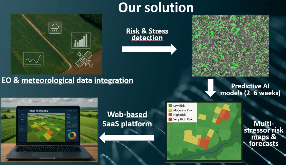
The innovation resulting from the project enables predictive, short-term (two to six weeks) assessment of multi-stressor crop risks, providing accurate and actionable information on drought, heat stress, pests and diseases. Accordingly, large agricultural areas can be analysed in a short time with low human resource requirements, supporting simultaneous evaluation of crop conditions at parcel to national scale.
By using the service, input suppliers can reduce input misuse by 10–15%, lowering costs and supporting compliance with EU sustainability regulations. At the same time, early-season forecasts improve logistics and distribution efficiency, reducing overstock and enabling more targeted product placement.
For insurance companies, predictive indicators support accurate pricing and the development of parametric insurance products. The system enables early risk mitigation, reducing payouts by up to €150–300/ha in stress years and improving loss ratios. EO-based validated risk maps also enable faster and more cost-efficient claims handling and more efficient reserve capital allocation.
Remote sensing data combined with AI models allows continuous monitoring and forecasting of crop conditions. The system provides precise spatial information on stress occurrence, supporting targeted interventions and improved decision-making across the value chain. With the implementation of continuous monitoring and forecasting, up-to-date information is available on evolving risks. If stress levels exceed defined thresholds, alerts are generated to support timely response by users and decision makers. This leads to improved production stability, strengthened supply chain resilience and reduced financial exposure, including potential reduction of non-performing loan ratios in agricultural portfolios.
The kick-off of the project took place on 07 April 2026. Following the kick-off, activities have been initiated to collect and consolidate user and system requirements through structured stakeholder interactions, focusing primarily on input suppliers and insurance companies. The results of this phase will be used to refine key functionalities, define system architecture and prioritise use cases.
The backbone of the platform builds on Envirosense Hungary’s existing developments, including the GeoRISK system used by agricultural insurers and previously developed EO-based crop monitoring and classification methodologies. These provide a validated starting point for predictive modelling and platform development.
Initial activities include the assessment of available EO, meteorological, soil and farm-level datasets, as well as the definition of preliminary system architecture, data flows and module interfaces. In parallel, key abiotic and biotic stressors are being identified and prioritised based on user relevance and modelling feasibility. The next milestone will focus on the integration of data sources and the development of predictive modelling workflows, including multi-stressor detection and short-term forecasting capabilities, as well as their implementation within the online platform.



 email
email  Facebook
  Twitter
  Linkedin
  Whatsapp
  Copy link