 Data Analytics, Insights & Applications
  Data Processing & Visualisation
 The Golden Twins platform addresses critical challenges faced by the tourism, maritime, and insurance sectors in Greek islands, offering real-time monitoring and risk management for forest fires, extreme weather events, and vessel activity. Key problems include the need for rapid detection and response to forest fires, timely alerts for extreme precipitation events and post event monitoring such as floods and debris flow, and comprehensive vessel tracking even in areas with limited AIS data.
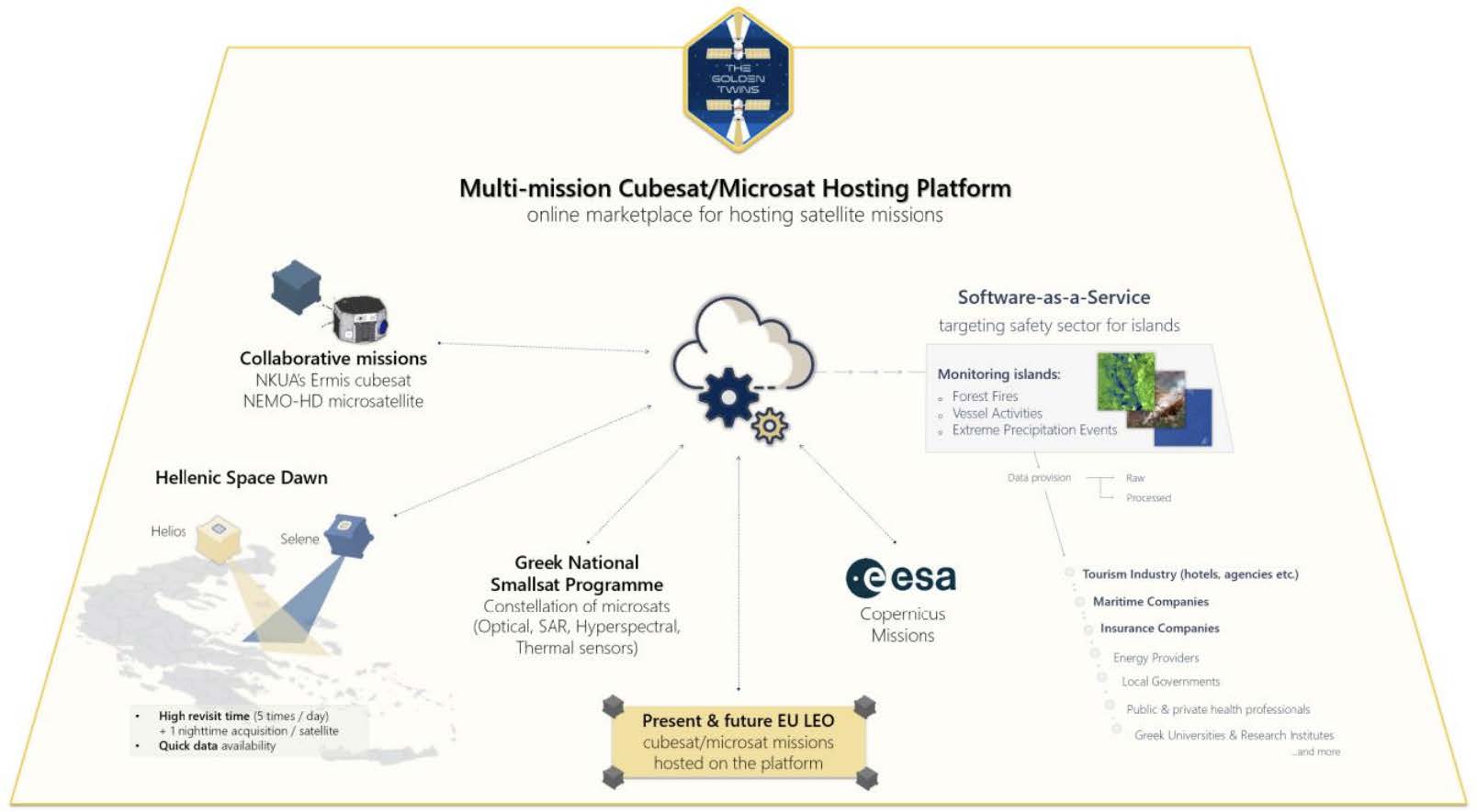
To solve these issues, Golden Twins leverages data from Greek CubeSat missions, Sentinel satellites, and Copernicus contributing missions, in order to provide standardised, real-time insights and risk assessments for fire prevention, extreme weather damage monitoring, and maritime safety.
By offering a system-agnostic, multi-mission hosting platform built on open standards, the Golden Twins platform aims to bridge the gap in the national space program and serve as a competitive, low-cost solution for the emerging EO market.
The Golden Twins platform targets customers in the tourism, maritime, and insurance sectors, specifically focusing on businesses operating on Greek islands. Key users include hotel management companies, maritime operators, and insurance firms, who all have the need for safety alerts, evacuation guidance, and risk assessments.
In tourism, the need is for real-time monitoring of forest fires and extreme weather events, providing safety alerts, evacuation guidance, and post-event damage assessments to protect tourists and properties. In the maritime sector, customers require vessel monitoring services, even for ships with limited AIS data, to ensure maritime safety, prevent illegal activities, and manage port congestion. The insurance sector seeks accurate and timely data for risk assessment and to expedite claims processing for natural disasters like fires and floods.
A number of users representing each of the sectors above actively participate as pilot users throughout the project, providing feedback through questionnaires and workshops regarding the platform’s functionalities, as well as guiding development through sprint reviews and participating in the verification and validation activities of services, the platform’s UI/UX, and the overall system.
Challenges include delivering high-resolution, real-time data for precise monitoring and rapid response, while ensuring seamless integration of LEO satellite missions and future micro-satellites to meet the growing demands for accurate, location-specific insights.
The Golden Twins platform provides a platform integrating several services
for monitoring islands. The starting case studies include Greece, with a possible launch in remote islands of the world in the future, where launching CubeSats might have a lower cost than acquiring commercial satellite data.
The Golden Twins is an advanced EO platform combining high-resolution data from CubeSats and open-access sources like Copernicus. It offers near real-time monitoring for sectors such as tourism, maritime, insurance, and environmental management.
The platform’s innovation lies in its high revisit rate (multiple times daily) and spatial resolution (1-10m), combined with AI-driven analytics and data fusion techniques. Services include rapid and accurate fire danger assessments, real-time fire monitoring, and detailed post-fire mapping; extreme precipitation events monitoring by reporting (alert, maps, plans) of floods with assessment of any subsequent debris flow and /or infrastructure damage; and vessel tracking using multiple data sources (SAR and multispectral data, AIS), providing rapid and accurate insights.
Users access the platform via a web-based interface to track incidents, generate reports, and receive customised alerts. The Golden Twins platform is scalable, cost-effective, and designed for adaptability, making it ideal for various commercial applications and operational requirements.
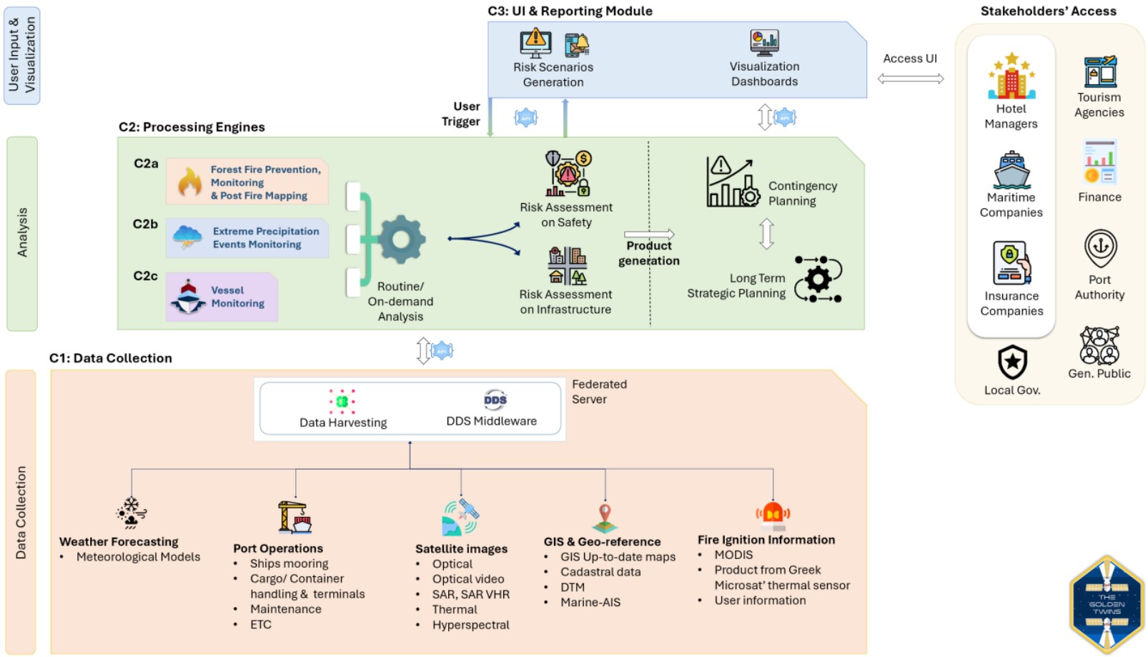
The Golden Twins platform consists of five (5) main components, also seen in the presented system architecture below. The main components of the platform product are:

The Golden Twins platform offers significant advantages over competitors by integrating widely used open EO data with data from CubeSat missions, leveraging their high revisit frequency and spatial resolution. This results in faster, more accurate monitoring for the three delivered services which monitor forest fires, extreme precipitation events, and vessel activities.
Additionally, The Golden Twins shall act as the first comprehensive commercial solution in Greece, serving commercial sectors such as tourism, insurance, and maritime, unlike government-focused competitors. Its scalable, cost-effective solution, using low-cost satellite missions, ensures widespread applicability, especially for remote islands.
The potential to include future CubeSat missions can further enhance these traits and add more services. The platform’s AI-driven real-time analysis, combined with advanced data fusion techniques, further distinguishes it from traditional methods.

The Golden Twins (GT) activity is nearing completion of its De-risking cycle, with user requirements, technical specifications, and service prototypes well defined. The project remains on track, engaging stakeholders in tourism, maritime, and insurance to ensure alignment with operational needs.
The BETA analytical services—C2a (fire monitoring), C2b (flood detection), and C2c (maritime analysis)—have partially or fully met required performance benchmarks and are being refined to suit real-world operational conditions through continuous testing and user feedback. This refinement is supported by continuous feedback loops and testing that maintain alignment with end-user expectations, marking a key step toward operational readiness.
The Unified Ingest and Preprocessing Platform (C1) has established its foundational structure and is progressing toward full operational capacity. Key development efforts are focused on expanding support for additional EO data sources, including upcoming Greek CubeSat missions and commercial datasets, as well as enhancing preprocessing workflows to manage this data effectively. Once fully developed, C1 will offer seamless integration of diverse data streams, optimising service delivery across the GT applications.
The Web Application (C3), the main user interface, has completed its design phase and is being enhanced for usability, secure access, and efficient alert management for users.
Looking ahead, integration of additional sensors and data sources is a priority, with development advancing toward the Factory Acceptance Test (FAT) and Site Acceptance Test (SAT) stages. These will validate the platform’s technical and operational readiness ahead of final deployment.
Golden Twins is well-positioned for commercialisation, following strong market analysis that highlights demand in Greece and other mediterranean countries with similar climate and economic profiles. Key strengths include real-time, multi-hazard EO services with high spatial/temporal resolution, modular architecture, and compatibility with future missions. Early partnerships with stakeholders in tourism, maritime, and insurance validate its relevance and impact.
The go-to-market strategy focuses on launching in Greece. Its flexible pricing model, multichannel outreach, and under finalisation branding support this rollout. Operational milestones from June 2025 to September 2026 include system validation (FAT/SAT), pilot onboarding, full launch, and performance monitoring.
Overall, Golden Twins is moving steadily toward the completion of its De-risking phase, transition into Product Development cycle and then full commercialisation.
Its early-stage market validation, strong technical development, and strategic business planning collectively position GT as a high-impact, scalable EO platform for risk management and operational decision-making across key economic sectors.


