PV solar energy capacity has grown 41% annually since 2009, with projections suggesting a ten-fold increase by 2040. Geospatial data is crucial for managing generation intermittency, climate change risks, and trade-offs with biodiversity. Existing data inventories lack detail, scope, localization, or updates to meet these needs.
SolarEye aims to map all commercial and utility-scale solar PV installations by applying machine learning techniques on Sentinel-2 imagery.
Objectives of the Product
The product offers an asset-level global inventory of commercial, industrial, and utility-scale PV installations. It enriches data with generating capacity, installation date, historic land cover, and proximity to protected areas and indigenous lands. This aids in understanding global land-cover patterns and facilitates decision-making regarding renewable energy deployment, considering factors like land use and political acceptability.
Unlike many facility-level datasets, SolarEye fills critical coverage gaps, especially in developing regions where solar PV adoption is essential for improving electricity access and cutting greenhouse gas emissions.
Customers and their Needs
The product targets various users including policymakers, land-planning authorities, and market intelligence companies in the renewable energy industry.
Policymakers utilise the data to align renewable energy policies with national goals and ensure effective design.
Land-planning authorities benefit from detailed maps of installed PV capacity for informed decision-making on land allocation and environmental impact management.
Market intelligence companies use the datasets for strategic decision-making and market insights.
User needs encompass an asset-level overview, precise location, plant outline for size assessment and land impact evaluation, installation year, and identification of land types utilised for solar deployment. Challenges entail maintaining data accuracy, accessibility, and relevance to diverse user requirements, while addressing market demand and regulatory compliance.
Targeted customer/users countries
SolarEye is designed to help a wide range of users across different industries and regions. It provides clear, reliable, and up-to-date data about solar PV installations to support better decisions. Key users include policymakers, land planners, market analysts, land developers, and environmental experts.
Policymakers
Policymakers need reliable data to shape renewable energy plans. SolarEye helps by providing:
Data to align solar energy policies with national and global climate goals.
Tools to create and manage strategies for expanding solar PV.
Insights to evaluate the impact of solar policies on communities and the environment
Land Planning Authorities
Land planners can use SolarEye’s maps and data to:
Understand the environmental effects of solar PV, like changes in land use and impacts on wildlife.
Identify the best places for future solar projects based on land availability and environmental considerations.
Balance solar development with responsible land management.
Market Intelligence Companies
Market analysts use SolarEye to:
Compare solar PV projects across regions and markets.
Predict market trends and find investment opportunities.
Track how solar PV installations have grown over time to guide business decisions.
Land Developers and Originators
Developers focused on solar projects benefit from SolarEye’s ability to:
Locate and assess land suitable for large-scale solar installations.
Evaluate environmental and regulatory factors before starting projects.
Simplify site selection using detailed maps and historical data.
Environmental Analysts
SolarEye helps environmental experts by offering data to:
Study the ecological effects of solar installations, especially near protected areas.
Track land-use changes caused by solar PV development.
Support research and advocacy for sustainable renewable energy practices.
Global Reach
SolarEye works for both developed and developing countries, offering insights tailored to different needs. It helps expand energy access in regions with limited electricity while supporting smarter renewable energy planning in mature markets.
By meeting the specific needs of its users, SolarEye makes it easier to expand renewable energy while balancing environmental and social priorities.
Product description
SolarEye leverages advanced computer vision techniques applied to Sentinel-2 satellite imagery to identify and map commercial and utility-scale solar PV installations worldwide. Sentinel-2, part of the Copernicus programme, provides high-resolution optical data that enables SolarEye to detect and delineate solar installations with precision.
Key Features and Methodology:
Global Detection of Solar PV Installations: SolarEye processes vast amounts of Sentinel-2 imagery to pinpoint the locations and boundaries of solar farms. The system’s machine learning algorithms are trained to distinguish solar PV installations from other land features, ensuring high accuracy across diverse landscapes and regions.
Backtracking Installation Timelines: By analysing historical satellite imagery, SolarEye can determine when a solar PV installation was constructed. This capability allows for the creation of a detailed timeline, showing the growth of solar energy deployment over time. Tracking the year of installation helps users understand trends in solar adoption and plan future development strategies.
Land Use Classification: SolarEye identifies the type of land that was converted for solar PV installations, such as agricultural fields, forests, or barren land. This information is crucial for evaluating the environmental impact of solar development, including changes to biodiversity and land use patterns.
Data Enrichment: The system not only identifies solar PV sites but also enriches this information with key attributes, such as:
Generating Capacity: Estimating the power output of installations.
Land Cover History: Providing insights into the land’s previous use before solar deployment.
Proximity to Protected Areas and Indigenous Lands: Highlighting potential trade-offs and conflicts with conservation efforts or cultural heritage.
Automated Scalability: SolarEye’s automation ensures that the system can continuously update its dataset as new satellite images become available. This keeps the data current and relevant for users who require real-time or near-real-time information.
Added Value
SolarEye provides critical information that supports smarter decisions and solves key challenges in solar PV development. Here’s why it adds value:
1. Comprehensive Data on Installation Dates
Why it matters: Knowing when solar PV installations were built helps track adoption trends, evaluate policy effectiveness, and plan for maintenance or upgrades. This ensures resources are allocated efficiently and future projects are better informed.
Added Value: Users gain a clear understanding of how solar capacity has grown over time, enabling better planning and investment strategies.
2. Detailed Information on Installation Size
Why it matters: Data on the physical size and capacity of installations helps assess their scale and potential impacts on local resources and ecosystems.
Added Value: Developers, investors, and planners can make more informed decisions about resource allocation, market opportunities, and project feasibility.
3. Insights into Historical Land Use
Why it matters: Knowing the previous land type (e.g., farmland, forest, or grassland) provides insight into the environmental impact of solar development, helping balance renewable energy growth with land conservation.
Added Value: Policymakers and planners can prioritise sustainable solar deployment, minimising conflicts with protected areas or sensitive ecosystems.
4. Reliable, Up-to-Date, Global Coverage
Why it matters: Many existing datasets are incomplete, outdated, or too localized to meet the needs of global users. SolarEye provides regularly updated, worldwide data that’s accessible and easy to integrate into existing tools.
Added Value: Users get a complete and current picture of global solar energy development, helping them stay ahead in a rapidly changing industry.
Current Status
The project was completed on 3 June 2025, with positive outcomes and approximately €20,000 in revenue generated during its cycle.
1. Final Results
Testing showed solid performance in terms of accuracy, precision, and recall, confirming the model’s ability to detect and map solar PV installations reliably.
These results provided a strong foundation for potential future use and development.
2. Integration with the Atlas Platform
SolarEye was integrated into the Atlas platform, making it easier for users to access solar insights alongside other geospatial tools.
This step helped improve the overall usability and relevance of the data.
3. Geographic Expansion
The model was further trained on data from less represented regions, especially parts of Asia and South America, to improve its generalisability.
This helped increase confidence in its application across different geographies.
4. Market Readiness
A go-to-market approach was outlined, exploring several options including partnerships, direct sales, and marketplace distribution.
Early revenue signals indicate encouraging commercial interest and potential.

 Data Analytics, Insights & Applications
  Data Processing & Visualisation
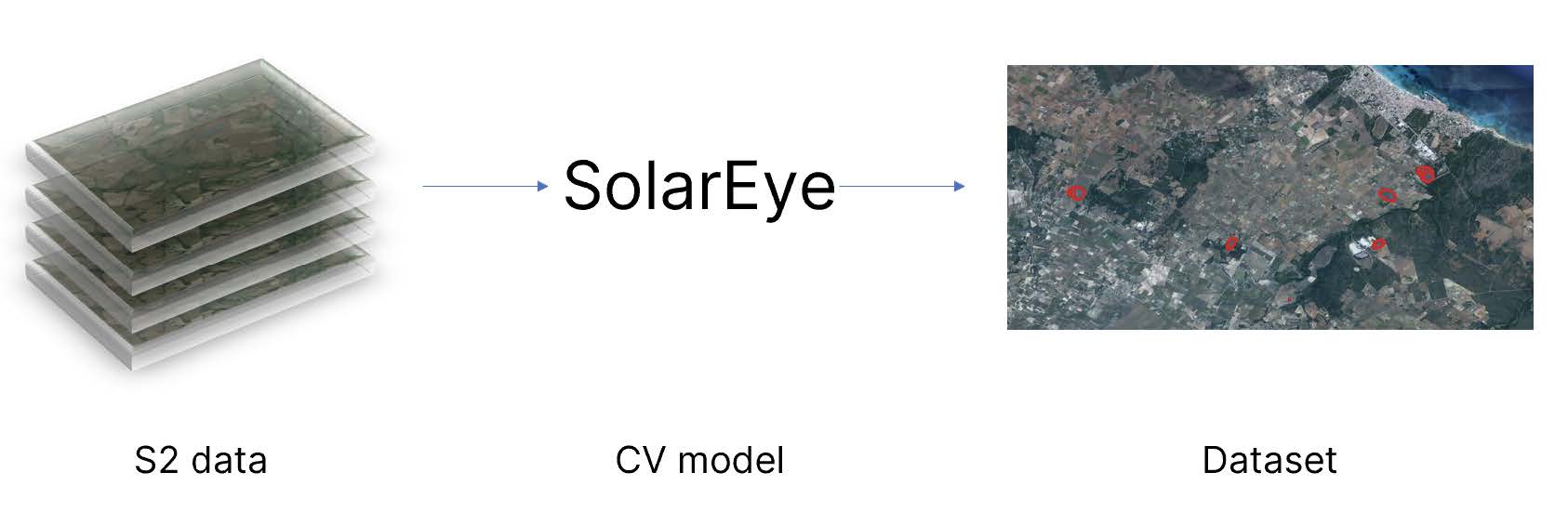

 email
email  Facebook
  Twitter
  Linkedin
  Whatsapp
  Copy link