
 Data Processing & Visualisation
 Make a list of six Sentinel-1 analysis ready data (ARD) products that are very easy to use for both human visual and machine-readable form. The idea is either one-click or one Application programming Interface (API) command integration and use. Make the most of Sentinel-1 input data with state-of-the-art calibration, thermal-noise removal, and speckle suppression. The S1 ARD products are targeted for several governmental and business users to help them in certain use cases as a useful input for analysis or to provide an end-user service.
The goal under CCN3 was to enable users to seamlessly subscribe to the Synthetic Normalised Difference Vegetation Index (SNDVI) API services and begin using them without requiring any human intervention from KappaZeta’s side. The service should be designed to automatically scale in response to demand, ensuring that it can handle varying levels of usage efficiently. At the same time, the service should be optimised to keep storage and processing costs to a minimum, making it cost-effective for both KappaZeta and its customers. Additionally, a sandbox environment should be provided where customers can try out the services, allowing them to explore and test the capabilities of the product.
Customers:
Needs:
European, South and North American, and Asian countries
Sentinel-1 Analysis Ready Data (ARD) layers:
The idea is to make satellite image accessible with one click or one API command (e.g., switch on the satellite WMS/WCS layer in your web/desktop GIS and data mining, machine learning frameworks). All the data layers will have state-of-the-art calibration, thermal noise removal, and speckle suppression.
Under CCN3, the new product will offer the following features over the current sNDVI service:
The pre-processing burden of SAR data is taken away. A lot of EO, GIS, and ICT companies and government institutions are not SAR experts, but they would benefit a lot from SAR data if it were provided in analysis ready format. In addition, utilising Synthetic Aperture Radar (SAR)-based biomass monitoring provides consistent and accurate data unaffected by cloud cover. This enables agricultural experts to navigate changing conditions with greater confidence and agility, regardless of weather patterns.
KappaOne has three interactive demo environments deployed, where users can observe fresh and historical Sentinel-1 data layers together with parcel statistics and synthetic NDVI:
The provided raster images illustrate KappaZeta’s vision of high-quality, high-resolution Sentinel-1 images that are processed to be useable for visual interpretation as well as for machine learning input. Visual interpretation is helped by the highest reasonable resolution, 5m grid cell, state-of-the-art speckle filtering method “Refined Lee”, careful contrast enhancement, and a selection of composite images.
As an advanced feature, temporal averaging can be selected to show cleaner, more detailed images. Despite all the efforts, direct interpretation of Sentinel-1 images is still challenging for non-trivial cases, so we also provide a synthesis of Sentinel-2 and Sentinel-1 images, which can provide an NDVI-like vegetation index for cloudy days. As a third product, we can deliver parcel-based time series of Sentinel-1 data, which uses a special parcel level noise reduction mechanism and is able to give a better signal-noise ratio than simple polygon extraction from the raster. All these products can be ordered via an API, which allows registered users to define new areas of interest, time period, list of parameters, set up a web map, generate download links, etc.
Under CCN3, several improvements were made to the previous sNDVI service offered under KappaOne. Key updates include:
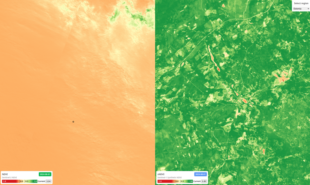
In addition, a web map platform was deployed as a sandbox environment for end-users and potential customers to explore SNDVI capabilities. The platform is accessible via:
The web map provides sample SNDVI data for six countries—Brazil, Estonia, Colombia, Latvia, Lithuania, Germany, and France. Users can upload parcel geometries in GeoJSON format to explore SNDVI values and generate time series for regions with available precomputed data.

 email
email  Facebook
  Twitter
  Linkedin
  Whatsapp
  Copy link