
 Data Analytics, Insights & Applications
 FANTOM supports the Department for Environment, Food & Rural Affairs ambition “to make our air purer, our water cleaner, our land greener and our food more sustainable. Our mission is to restore and enhance the environment for the next generation, and to leave the environment in a better state than we found it.”
FANTOM builds a high spatial and temporal resolution UK-centric database of agriculture and biodiversity markers with deep thematic content and context to support schemes aimed at the UK’s Agricultural Transition as well as supporting Net Zero and climate change activities.
These markers, schemes and impact assessment layers will be available to all government agencies, associated arms-length bodies, and commercial companies to be able to monitor and measure the progress of their sustainability activities and interventions.
Initially focused on delivering markers to support schemes for agricultural Paying Agencies, the aim is to ensure that the markers and schemes have a wider commercial need across government, non-government and commercial markets.
Furthermore, it will change the current perception of Earth observation-based land monitoring that not only looks at the asset but also its relationship with neighbouring assets to support landscape-level sustainability activities across the wider landowning community.
FANTOM’s primary intended customers are agricultural Paying Agencies in the United Kingdom and the European Union.
First, these organisations deal with a huge number of landowners and require ongoing information on their customer base. This assessment demands automated and reliable satellite data analytics to ensure that subsidies and interventions are made correctly and can be monitored.
Second, there are a wide range of users interested in monitoring their land to evaluate its habitat quality and biodiversity value. This includes Paying Agencies but also other government bodies such as Environmental Ministries plus commercial actors such as developers, infrastructure owners and more. These users face the challenge of understanding the impact of their actions on the wider landscape.
UK, EU
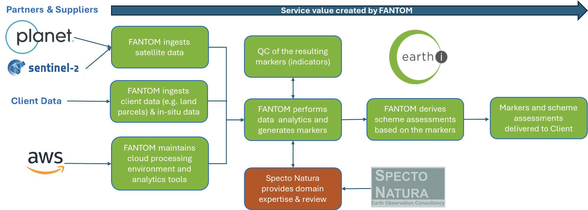
FANTOM delivers high spatial and temporal resolution markers to support agri-environmental schemes through the analysis of EO data and its integration with ancillary information.
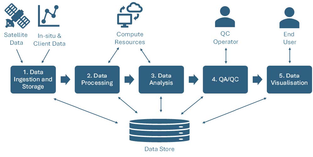
The main subsystems and components of FANTOM are:
1. Data Ingestion and storage: handled primarily by Earth-i’s existing satellite and in situ data processing workflow with necessary customisation for FANTOM.
2. Data Processing:
Depending on the marker requirements:
3. Data Analysis: analytics performed using a combination of sophisticated computer vision techniques and machine learning models to pick out specific identifiable features in the source satellite data. Outputs the markers required for the individual scheme assessments.
4. QA/QC Pipelines: QA/QC pipelines allow both manual and automated intervention.
5. Data visualisation: using existing platforms and open-source tools, visualisation will allow the user to overlay the resulting markers on the map, chart the outcomes and make rapid statistical assessments of marker outcomes and scheme results.
FANTOM will reduce the amount of time that it would otherwise take Paying Agencies to generate a full and comprehensive set of monitoring indicators for the new Environmental Land Monitoring approach being rolled out across the UK as the successor to the EU Common Agricultural Policy.
This means they will be able to monitor compliance and effectiveness of new policies right from the outset. The data products themselves represent value in the form of the customised, rigorously tested algorithms developed and implemented, along with a robust quality control regime, providing data that can be relied upon and can be verified with physical observations in the field. The markers and scheme assessment outputs scale reliably to address the Impact Potential, Technical Feasibility and Financial Viability of the monitoring.
FANTOM can promote the integration of ecological knowledge about the landscape into a data product, and model the change of the Habitat Quality and Biodiversity Potential so that customers can consider how a scheme is influencing changes over time and integrate this into policy development.
The FANTOM project kicked off in March 2025. The first phase of the project is focused on consolidating the requirements baseline through workshops with key end users and stakeholders. The workshops explore the technical, performance, timeliness, quality and product format requirements. The requirements baseline prioritises the development of properties that are key to the assessment of multiple Markers, Schemes or Regulations.

 email
email  Facebook
  Twitter
  Linkedin
  Whatsapp
  Copy link