

 Data Analytics, Insights & Applications
  Data Processing & Visualisation
 Existing tabular compute engines are not built for raster data.
The problem is that existing compute engines force users to manually catalogue, shard, and mosaic their raster data for distributed compute and integration. This slows down spatial data science, making professionals lose weeks to manual data preparation and awkward workarounds, instead of gaining insights and scaling capabilities.
As a solution, Ellipsis Map Engine brings users map-native, distributed analysis to all their geospatial data types so they can run their workflows instantly, without the manual work. It’s the missing piece, the fit-for-purpose raster data Lakehouse that brings users fast and easy spatial data science at scale:
The targeted user segments are Space/EO-powered value-adders, Civil Engineering – environmental (hazard), water and/or geotechnical engineering and consulting -, and P&C/Ag. insurance (insurance, reinsurance, GIS/NatCat data and/or consulting services).
Because the state of the art in performant geospatial data analytics currently lacks the possibility to create raster-native frameworks, the existing table-native engines are unable to automatically ingest and spatially shard raster data, leaving the job of catalogue building, sharding and mosaicking to the end user. This is a major handicap for our target customer segments (all professionals who rely on EO/spatial data and who want to use and integrate this into data science workflows, either for internal use or to provide better/new services to clients). The lack of infrastructure that supports such interactive data science on raster data is increasingly painful because EO and environmental data (commonly found in raster format) are increasingly relevant due to climate change and environmental risks that are affecting the industries of our target customers.
End users (representing each of the target segments) are involved in the activity as pilot users and will provide us with feedback and validation throughout the project.
Committed pilot users are confirmed for The Netherlands and France. Our target segments have a global presence and Ellipsis Map Engine, as an infrastructure solution, is not geographically limited.
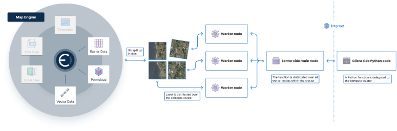
Under this activity, we are building the Ellipsis Map Engine. This product complements existing table engines by uniquely allowing users to load any EO and spatial data into a cluster, and have each node automatically host a section of the dataset based on geography (spatial sharding). So, when a Python command is created, it can be run both rapidly and geospatially aware, as each node in the cluster only needs to execute the command for the geographic section it has loaded. This simple but effective strategy supports use cases in which ever changing spatial logic needs to be applied to large raster/spatial data on-the-fly.
Our team’s existing product, Ellipsis Drive, is a central repository for discovering, managing and consuming spatial data across teams, organisations and workflows. Clients pay a monthly/quarterly/yearly fee to use Ellipsis Drive to search, access and leverage their EO/spatial datasets as high performance and interoperable web services (storage-based PaaS model). The Ellipsis Map Engine is an extension to this existing solution, adding the option to apply flexible and high-performance analytics to the spatial data that customers are hosting (adding a fee for use of Processing Units under the same Paas model).
Users can automatically run arbitrary logic on any EO/spatial data in a distributed and spatially aware way and use results in both GIS and non-GIS systems instantaneously. This unique capability allows them to get answers to ad hoc spatial analysis challenges easily and time efficiently, just like they are used to when analysing table-native data with regular tabular engines. Thus, this tool creates value for Data Scientists, Actuaries and Geo Engineers who work with EO and EO-derived (raster) data, allowing these professionals to apply complex – and ever changing – analytics to spatial/EO data in a highly time-efficient way.
For Data Scientists, consultants, and actuaries in P&C/Ag. (re)insurance, this directly supports highly effective pricing, (aggregate) risk mapping, portfolio management and claims operations (all processes relying on EO/raster data and ad hoc spatial logic).
For Data Scientists, Consultants and (Geo)Engineers in civil engineering this means getting the answers to their client’s questions much more quickly and accurately, including for governments, environmental agencies as well as energy and utility companies. For Data Scientists and Consultants working at EO value-adding companies, providing flexible and ad hoc EO-powered data services is much easier and more cost efficient.
The activity passed the Critical Design Review. Ellipsis Map Engine is seeing early usage on its beta release that is driven by users’ interest to test relevant workflows for their use cases. Currently, the project team is working to finalise a stable release for the Factory Acceptance Test later this year. Thanks to targeted marketing and pre-sales outreach, we are seeing market interest in Ellipsis Map Engine capabilities grow and are experiencing traction in the form of information requests from in-bound prospects, formalisation of pilots with out-bound prospects and inclusion in proposals with GTM partners.


 email
email  Facebook
  Twitter
  Linkedin
  Whatsapp
  Copy link