 Data Analytics, Insights & Applications
 Countries where high real-estate taxes exist also have issues with illegal constructions, because some people try to avoid paying the respective tax. The solution helps municipalities find owners who are not properly paying real-estate taxes by detecting buildings from satellite images.
Based on satellite data, the solution identifies new construction activities in an area. It filters out unlawful activities based on building registry data, enabling the automatic filtering of illegal activities from all detected construction activities. The web application not only detects constructions not paying the (proper) real-estate tax but also helps municipalities to contact the real-estate owners so they can start paying the tax properly.
We provide this solution by recognising buildings from high-resolution satellite images. To do so, we utilise machine learning algorithms on satellite data, to recognise construction activities and combine this data with building register data for our target use case.
Municipalities face substantial issues with undeclared constructions, resulting in lost tax revenue. The main issues include unpermitted swimming pools and extensions in private properties. Apart from the financial issue, illegal constructions also create a security problem, especially with pools that can be very dangerous when built on higher floors. In this case, they could potentially damage the structure of the building. Such cases are also more difficult to discover through manual inspection because officials have limited access to buildings.
Current methods, such as relying on citizen complaints and manual inspections, are inefficient and labor-intensive. Municipalities recognise the income loss from manual systems and are seeking more efficient methods.
Target customer: local municipalities
Primary focus: Spain
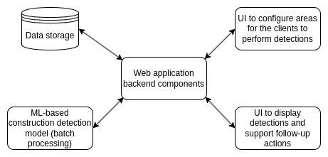
The core of the product is the capability to detect objects of interest (buildings and pools) from 30 cm-resolution satellite data with sufficient precision and recall to support our business logic. Detections are compared with information on registered buildings to identify unregistered and misregistered buildings.
From the customer’s perspective, detections will be served to the client via a web application that has supporting features for follow-up actions regarding misregistered buildings (such as sending notices).

Several companies in the market offer solutions for infrastructure monitoring based on data from satellites. One aspect, that sets our offering apart from the companies already operating in the market, is that our solution foresees integration with building registers, which enables automatic filtering of illegal actives from all detected construction activities.
The following tasks were covered in the de-risking activity:
1) validation and improvement of the requirements specification.
2a) utilisation of machine learning algorithms on satellite data, with sufficient precision and suitable to offer construction surveillance services in Spain.
2b) combination of satellite data with building register data for our target use case.
The Product Development phase will most likely continue, where the web application of the product will be developed.